Link to USGS home page.
Scientific Investigations Map 2875
  About USGS /  Science Topics /  Maps, Products & Publications /  Education / FAQ

Distribution of Late Quaternary Wind-deposited Sand in Eastern Colorado

By Richard F. Madole, D. Paco VanSistine, and John A. Michael

thumbnail image of map

During historic time, inhabitants of the Great Plains have experienced a succession of climatically driven cycles of economic boom and bust. Drought has been the primary driver of bad times because of its impact on water supplies, crops, and grazing land. In addition, prolonged droughts have set the stage for massive wind erosion and huge dust storms. With or without global warming, droughts will continue to occur and will affect the economy and social fabric of the region. Droughts cannot be prevented, but an improved understanding of their causes and effects can provide a basis for planning that will minimize negative impacts on society.

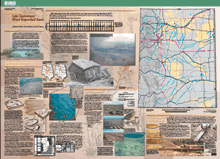
The period during which meteorological data have been recorded in eastern Colorado is far too short to encompass the full range of variability possible under the present climate. An understanding of the long-term pattern of climate change is required to plan for changes that are likely to occur in the near future and to anticipate the effects that these changes will have on humans and the environment. This map is part of a U.S. Geological Survey project, the purpose of which is to determine the range of climate variability possible on the western Great Plains in the 21st century and to achieve a better understanding of the effects of slight changes in climate on dune reactivation, dust-storm generation, water supplies, land use, and wildlife habitat.

Available at USGS Information Services (1-888-ASK-USGS)

Version 1.0

Posted November 2005

Part or all of this report is presented in Portable Document Format (PDF); the latest version of Adobe Acrobat Reader or similar software is required to view it. Download the latest version of Acrobat Reader, free of charge..


For viewing and printing upon download.
     Text-Only PDF (2.3 MB) This version of the pamphlet is accessible, as defined in Section 508 of the Rehabilitation Act of 1973, Amendments of 1998.)
This geospatial database consists of ArcInfo export files (.e00) and ArcView shapefiles contained in a gzipped tar archive or zip archive. Both compressed archive files contain both types of geospatial database files.
Metadata file  Detailed metadata documentation for this geospatial database.

*Downloading Suggestion: It is best to download a large PDF file to your hard drive rather than open it inside your browser.  A standard click may automatically open the PDF file inside the browser but doing so will result in a very slow load.
                For guidance on how to do this, go to [http://cpg.cr.usgs.gov/toolbox/download_advice.html].
Downloading the PDF file may take several moments but will be worth the wait.   Once it is downloaded, open the PDF from your hard drive using Adobe Acrobat—it will open in a fraction of the time it would take to open the PDF over the Internet.

USA.gov logo