|
The Lower Silurian regional oil and gas accumulation was named by Ryder and Zagorski (2003) for a 400-mile (mi)-long by 200-mi-wide hydrocarbon accumulation in the central Appalachian basin of the Eastern United States and Ontario, Canada. From the early 1880s to 2000, approximately 300 to 400 million barrels of oil and eight to nine trillion cubic feet of gas have been produced from the Lower Silurian regional oil and gas accumulation (Miller, 1975; McCormac and others, 1996; Harper and others, 1999). Dominant reservoirs in the regional accumulation are the Lower Silurian "Clinton" and Medina sandstones in Ohio and westernmost West Virginia and coeval rocks in the Lower Silurian Medina Group (Grimsby Sandstone (Formation) and Whirlpool Sandstone) in northwestern Pennsylvania and western New York. A secondary reservoir is the Upper Ordovician(?) and Lower Silurian Tuscarora Sandstone in central Pennsylvania and central West Virginia, a more proximal eastern facies of the "Clinton" sandstone and Medina Group (Yeakel, 1962; Cotter, 1982, 1983; Castle, 1998).
The Lower Silurian regional oil and gas accumulation is subdivided by Ryder and Zagorski (2003) into the following three parts: (1) an easternmost part consisting of local gas-bearing sandstone units in the Tuscarora Sandstone that is included with the basin-center accumulation; (2) an eastern part consisting predominantly of gas-bearing "Clinton" sandstone-Medina Group sandstones that have many characteristics of a basin-center accumulation (Davis, 1984; Zagorski, 1988, 1991; Law and Spencer, 1993); and (3) a western part consisting of oil- and gas-bearing "Clinton" sandstone-Medina Group sandstones that is a conventional accumulation with hybrid features of a basin-center accumulation (Zagorski, 1999). With the notable exception of the offshore part of Lake Erie (de Witt, 1993), the supply of oil and (or) gas in the hybrid-conventional part of the regional accumulation continues to decline because of the many wells drilled there since the late 1880s. However, new gas and local oil continues to be discovered in the deeper basin-center part (Zagorski, 1991; Pees, 1994; Petroleum Information Corporation, 1994). In general, only small quantities of gas have been produced from the Tuscarora Sandstone fields because of their generally poor reservoir quality and because of the low energy (Btu) content of the gas (Avary, 1996). Although fracture porosity is the dominant porosity type in the Tuscarora Sandstone gas reservoirs (Avary, 1996), there are several fields, such as Indian Creek, where intergranular porosity seems to be important (Bruner, 1983; Castle and Byrnes, 2005).
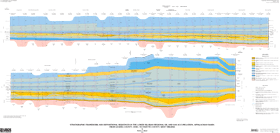
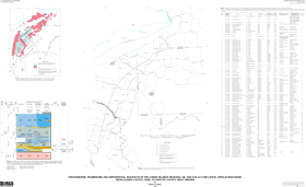
In order to better understand the character and origin of the Lower Silurian regional oil and gas accumulation and its component parts, six cross sections were drawn through the Lower Silurian strata in parts of New York, Ohio, Pennsylvania, and West Virginia. The locations of all six cross sections are shown on sheet 2 (figs. 1 and 2) of this report. Each cross section shows the stratigraphic framework, depositional setting, sequence stratigraphy, and hydrocarbon-producing intervals of the Lower Silurian sandstone reservoirs and adjoining strata. Cross section F–F′ presented here is about 215 mi long and trends northwestward, approximately normal to the depositional strike of the Lower Silurian sandstone system, and extends through large stretches of the basin-center and hybrid-conventional parts of the Lower Silurian regional oil and gas accumulation. |
|
|