Scientific Investigations Map 2817-E
Prepared in cooperation with the Alaska Division of Oil and Gas, Anchorage, Alaska, and Alaska Divison of Geological and Geophysical Surveys, Fairbanks, Alaska
1Alaska Division of Oil and Gas, Anchorage, AK 99501
2 U.S. Geological Survey, Reston, VA 20192
3Alaska Division of Geological and Geophysical Surveys, Fairbanks, AK 99709

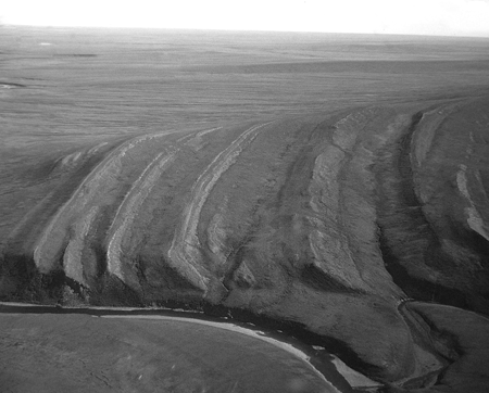
Lower part of the Nanushuk Formation on the south flank of the Archimedes Ridge anticline along the Kukpowruk River. |
AbstractThis map is a product of the USGS Digital Geologic Maps of Northern Alaska project, which captures in digital format quadrangles across the entire width of northern Alaska. Sources include geologic maps previously published in hardcopy format and recent updates and revisions based on field mapping by the Alaska Department of Natural Resources, Division of Geological and Geophysical Surveys and Division of Oil and Gas, and the U.S. Geological Survey. Individual quadrangles are digitized at either 1:125,000 or 1:250,000 depending on the resolution of source maps. The project objective is to produce a set of digital geologic maps with uniform stratigraphic nomenclature and structural annotation, and publish those maps electronically. The paper version of this map is available for purchase from the USGS Store. For more information concerning the report, please contact the author. Readme File [29 KB, 3 pages] |
This document is available online in Portable Document Format (PDF); the latest version of Adobe Acrobat® Reader or similar software is required to view it. Download the latest version of Acrobat® Reader, free of charge or go to access.adobe.com for free tools that allow visually impaired users to read PDF files.