Scientific Investigations Map 2830
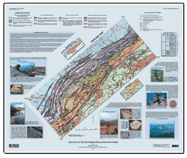
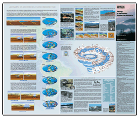
SUMMARYThe Southern Appalachian Mountains includes the Blue Ridge province and parts of four other physiographic provinces. The Blue Ridge physiographic province is a high, mountainous area bounded by several named mountain ranges (including the Unaka Mountains and the Great Smoky Mountains) to the northwest, and the Blue Ridge Mountains to the southeast. Metamorphic rocks of the mountains include (1) fragments of a billion-year-old supercontinent, (2) thick sequences of sedimentary rock that were deposited in subsiding (sinking) basins on the continent, (3) sedimentary and volcanic rocks that were deposited on the sea floor, and (4) fragments of oceanic crust. Most of the rocks formed as sediments or volcanic rocks on ocean floors, islands, and continental plates; igneous rocks formed when crustal plates collided, beginning about 450 million years ago. The collision between the ancestral North American and African continental plates ended about 270 million years ago. Then, the continents began to be stretched, which caused fractures to open in places throughout the crust; these fractures were later filled with sediment. This product (U.S. Geological Survey Scientific Investigations Map 2830) consists of a geologic map of the Southern Appalachian Mountains overlain on a shaded-relief background. The map area includes parts of southern Virginia, eastern West Virginia and Tennessee, western North and South Carolina, northern Georgia and northeastern Alabama. Photographs of localities where geologic features of interest can be seen accompany the map. Diagrams show how the movement of continental plates over many millions of years affected the landscapes seen today, show how folds and faults form, describe important mineral resources of the region, and illustrate geologic time. This two-sided map is folded into a convenient size (5×9.4 inches) for use in the field. The target audience is high school to college earth science and geology teachers and students; staffs of educational and interpretive programs within Federal, State, and private agencies; and tourists and residents of the Southern Appalachian region who want to know more about the area. The map is companion to the DVD, “The Southern Appalachians, a Changing World” (https://pubs.usgs.gov/gip/so_app/) and the Teacher’s Guide and brochure, “Birth of the Mountains” (https://pubs.usgs.gov/gip/birth). The map shows the location of sites that are featured in these publications. |
First posted December, 2008 Part or all of this report is presented in Portable Document Format (PDF); the latest version of Adobe Reader or similar software is required to view it. Download the latest version of Adobe Reader, free of charge. |
Clark, S.H.B., 2008, Geology of the Southern Appalachian Mountains: U.S. Geological Survey Scientific Investigations Map 2830, 1 two-sided sheet, also available online at https://pubs.usgs.gov/sim/2830/.

![]() U.S. Department of the Interior |
U.S. Geological Survey
U.S. Department of the Interior |
U.S. Geological Survey
URL: https://pubsdata.usgs.gov/pubs/sim/2830/
Page Contact Information: Contact USGS
Page Last Modified: Thursday, 01-Dec-2016 17:12:54 EST