|
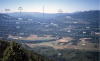
TKeb-2. View east from Mount Index [SKnw] across Skykomish River valley to peaks of Baring Mountain [SKne], erosion-resistant migmatitic gneiss (TKebg) that forms a tectonic slice in less resistant sedimentary rocks of the eastern mélange belt (TKeb). Townsend Mountain and Grotto Mountain are granodiorite of Miocene Grotto batholith (Snoqualmie Family, Tcas), the eroded root of a Cascade Magmatic Arc volcano. Mountains on skyline beyond are carved from rocks of Nason terrane (in Wenatchee block), predominantly Late Cretaceous Chiwaukum Schist (Kncs) and Mount Stuart batholith (Kt). Foreground rock is Jurassic metagabbro, a tectonic slice mixed into western mélange belt (TKwb) in latest Cretaceous or early Tertiary. Tcai, Index batholith (Index family of Cascade Magmatic Arc); Tev, volcanic rocks of extensional deposits; Qa, alluvium of valley floor. Contacts dashed where approximately located and dotted where hidden. This photo is figure 15 in the accompanying report (sheet 2). View image with annotation
|