
|
|
Scientific Investigations Map 2940 |
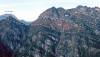
| TKso-2. The Southern Picket Range [MBne] eroded from orthogneiss of the Skagit Gneiss Complex (TKso). Telephoto view northeast from Anderson Butte [MBsw]. Tcai, granodiorite of the Oligocene Chilliwack batholith (Cascade Magmatic Arc, Index family); Tes, sandstone of extensional deposits; Kes, Early Cretaceous Shuksan Greenschist, Shuksan nappe, Easton terrane of the Northwest Cascade System. Names in italics are informal but much used locally. Photographed in 1978. View image with annotation |

|
Other photos that show unit TKso:
  |