
|
|
Scientific Investigations Map 2940 |
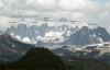
| Tcai-2. Oligocene granodiorite of the Chilliwack batholith (Index family, Tcai) exposed on the ridge west of the upper East Fork of Bacon Creek [MBse]. View northeast to the Northern Picket Range. Glacial erratics on this glacier-smoothed surface at ~2,000 m elevation indicate that the Cordilleran Ice Sheet covered the ridge. |

|
Other photos that show unit Tcai:
   |