Scientific Investigations Map 3030
In cooperation with the
PUERTO RICO DEPARTMENT OF NATURAL AND ENVIRONMENTAL RESOURCES
ONLINE ONLY
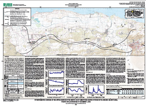
A ground-water level synoptic survey of the limestone aquifer in the Arecibo to Manatí area, Puerto Rico, was conducted from November 27 through December 1, 2006 by the U.S. Geological Survey in cooperation with the Puerto Rico Department of Natural and Environmental Resources. The purpose of the study was to define the spatial distribution of the potentiometric surface of the upper and lower aquifers of the North Coast limestone aquifer system. A potentiometric surface is defined as an areal representation of the levels to which water would rise in tightly cased wells open to an aquifer (Fetter, 1988). These potentiometric surface maps can be used by water-resources planners to understand the general direction of ground-water flow and to evaluate ground-water conditions for water supply and resource protection. The study was conducted during a period of rising ground-water levels resulting from above-normal rainfall during October and November 2006 when rainfall amount was about 30 percent above normal. The study area encompassed 125 square miles and was bounded to the north by the Atlantic Ocean, to the south by the southern extension of the limestone units, to the west by the Río Grande de Arecibo, and to the east by the Río Grande de Manatí (pls. 1 and 2; inset). |
Posted December 2008 Please visit http://pr.water.usgs.gov/ for more information about USGS activities in the Caribbean (Puerto Rico and the U.S. Virgin Islands).
Part or all of this report is presented in Portable Document Format (PDF); the latest version of Adobe Acrobat Reader or similar software is required to view it. Download the latest version of Acrobat Reader, free of charge or go to access.adobe.com for free tools that allow visually impaired users to read PDF files. |
Rodríguez, J.M., Gómez-Gómez, F., 2005, PPotentiometric surface of the upper and lower aquifers of the North Coast Limestone aquifer system and hydrologic conditions in the Arecibo-Manatí area, Puerto Rico, November 27-December 1, 2006: U.S. Geological Survey Scientific Investigations Map 3030, 2 sheet.

![]() U.S. Department of the Interior |
U.S. Geological Survey
U.S. Department of the Interior |
U.S. Geological Survey
URL: http://pubsdata.usgs.gov/pubs/sim/3030/index.html
Page Contact Information: GS Pubs Web Contact
Page Last Modified: Thursday, 01-Dec-2016 17:10:55 EST