Scientific Investigations Map 3073
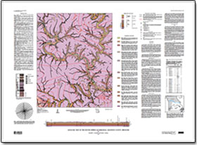
AbstractThe Round Spring 7.5-minute quadrangle is located in Shannon County, south-central Missouri on the Salem Plateau of the Ozark Plateaus physiographic province. As much as 1,350 feet (ft) of flat-lying to gently dipping Upper Cambrian and Lower Ordovician rocks, mostly dolomite, overlie Mesoproterozoic volcanic rocks. The bedrock is overlain by unconsolidated residuum, colluvium, terrace deposits, and alluvium. Karst features, such as small sinkholes and caves, have formed in the carbonate rocks, and many streams are spring fed. The topography is a dissected karst plain with elevation ranging from 650 ft along the Current River on the eastern edge of the quadrangle to almost 1,200 ft at various places on the ridge tops. The area is mostly forested but contains some farmlands and includes sections of the Ozark National Scenic Riverways of the National Park Service along the Current River. Geologic mapping for this investigation began in the spring of 2001 and was completed in the spring of 2002. |
First posted July 2009
For additional information, please contact the author. Part or all of this report is presented in Portable Document Format (PDF); the latest version of Adobe Reader or similar software is required to view it. Download the latest version of Acrobat® Reader, free of charge. |
Suggested citation:
Orndorff, R.C., and Weary, D.J., 2009, Geologic map of the Round Spring quadrangle, Shannon County, Missouri: U.S. Geological Survey Scientific Investigations Map 3073, scale 1:24,000. (Also available online at
https://pubs.usgs.gov/sim/3073/.)

![]() U.S. Department of the Interior |
U.S. Geological Survey
U.S. Department of the Interior |
U.S. Geological Survey
[an error occurred while processing this directive]
URL: https://pubsdata.usgs.gov
Page Contact Information: Contact USGS
Page Last Modified: Thursday, December 01 2016, 05:15:18 PM
