 Summary Summary
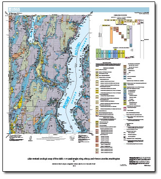
The Olalla 7.5' quadrangle, which lies almost in the center of the Puget Lowland, displays the broad range of geologic environments typical of the region. The upland plain is fluted by the passage of the great continental ice sheet that last covered the area about 17,000 (14,000 radiocarbon) years ago. The plain is cut by channel deposits, both late glacial and postglacial in age, and it is cleaved even more deeply by one of the major arms of Puget Sound, Colvos Passage, which here separates the west coast of Vashon Island from the Kitsap Peninsula.
Beneath the deposits of the last ice sheet is a complex sequence of older Quaternary-age sediments that extends about 400 m below the modern ground surface. These older sediments are best exposed along the shorelines and beach cliffs of Puget Sound, where wave action and landslides maintain relatively fresh exposures. The older sediments typically are compact, having been loaded by ice during one or more episodes of glaciation subsequent to their deposition. Locally these sediments are also cemented by iron and manganese oxides and hydroxides, a consequence of many tens or hundreds of thousands of years of weathering and groundwater movement.
Our map is an interpretation of a 6-ft resolution lidar-derived digital elevation model combined with the geology depicted on the "Geologic map of the Olalla 7.5' quadrangle, King, Kitsap, and Pierce Counties, Washington," by Booth and Troost (2005), which was described, interpreted, and located on the 1953 1:24,000-scale topographic map of the Olalla 7.5-minute quadrangle. The original topographic base map, derived from 1951 aerial photographs, has 20-ft contours, nominal horizontal resolution of circa 40 ft (12 m), and nominal mean vertical accuracy of circa 13 ft (4 m). This new DEM has a horizontal resolution of 6 ft (2 m) and mean vertical accuracy circa 1 ft (0.3 m). The greater resolution and accuracy of the lidar DEM facilitated a much-improved interpretation of many aspects of the surficial geology, especially the distribution and relative age of landforms and the materials inferred to comprise them.
|
First posted January 6, 2014
Part or all of this report is presented in Portable Document Format (PDF). For best results viewing and printing PDF documents, it is recommended that you download the documents to your computer and open them with Adobe Reader. PDF documents opened from your browser may not display or print as intended. Download the latest version of Adobe Reader, free of charge.
|

