Scientific Investigations Report 2005–5215
U.S. GEOLOGICAL SURVEY
Scientific Investigations Report 2005–5215
Water quality in the lower Boise River has changed over time due to anthropogenic activities such as land-use changes, increased urbanization, and an altered flow regime in the Boise River (MacCoy, 2004). The lower Boise River was listed as water-quality limited in 1992 in accordance with Section 303(d) of the Clean Water Act (Idaho Department of Environmental Quality, 1999). This listing required the development of a total maximum daily load (TMDL) management plan for the lower Boise River. The management plan includes TMDLs for nutrients, suspended sediment, bacteria, elevated water temperature, and low dissolved-oxygen concentrations.
The Lower Boise River Water Quality Plan, Inc. (LBRWQP) was formed in 1992 with membership composed of public and private agencies, groups, and individuals. The LBRWQP’s mission is to identify water-quality problems, to initiate voluntary water-quality management practices, and to monitor the long-term effectiveness of these practices on the water quality and biotic integrity of the lower Boise River. In 1994, in cooperation with the LBRWQP and the Idaho Department of Environmental Quality (IDEQ), the U.S. Geological Survey (USGS) began a comprehensive, 8-year study to assess water quality and biotic integrity of the lower Boise River using a combination of reconnaissance, synoptic, and interval water-quality sampling, in addition to annual biological sampling.
A 2001 synoptic study estimated that as much as 150 lb/d of dissolved phosphorus and 215 lb/d of total nitrogen, likely from ground-water seepage, was entering the Boise River approximately between river miles (RM) 2 and 4 (MacCoy, 2004). Results of the synoptic study indicated (1) the potential for significant seepage of nutrients into the lower Boise River from ground water, and (2) the need for a more focused study of ground-water and surface-water interaction. In 2003, the present study was designed and implemented to identify and estimate seepage between ground water and the lower Boise River. Seepage estimates might be used to help determine the approximate amount of nutrients being transported between ground water and the lower Boise River.
Historically, surface water and ground water were evaluated as distinct, independent resources to be utilized and managed separately. Over time, the interconnection of these two resources became clearer; surface water and ground water are, in fact, part of a single, interconnected water resource (Winter and others, 1998). For example, when one component of the water resource increases or decreases, the other component responds similarly, thereby complicating efforts to manage the two water components separately. Therefore, an understanding of the interconnections between surface water and ground water is essential to effectively managing water resources.
One indicator of these interconnections is temperature. Water exchange between surface water and ground water affects temperatures not only in the two water components, but also in the sediments near them. Therefore, analyses of subsurface temperature patterns provide information about surface-water and ground-water interaction. Modeling the transport of heat can thus improve understanding of the magnitudes and mechanisms of water exchange between the two resources (Stonestrom and Constantz, 2003).
Heat has long been identified as a potential tracer of water exchange between streams and ground-water systems (Rorabaugh, 1954; Lapham, 1989). Continuing improvements in data-acquisition and computation have enabled the economical and routine application of heat as a hydrologic tracer. The USGS model VS2DI (Hsieh and others, 2000) has been used to simulate the transport of heat between surface water and ground water in different environments from ephemeral to perennial streams (Silliman and Booth, 1993; Bartolino and Niswonger, 1999; Su and others, 2004).
The objective of this study is to estimate the flux between ground water and surface water within a 3 river-mile reach of the lower Boise River using heat as a tracer. Two-dimensional models of four transects along the 3-river mile reach were created using the USGS model, VS2DI. The two-dimensional models represent temperature and flow conditions in the four transects from April to August 2003.
The author wishes to extend thanks to the Boise Field Office for the arduous task of piezometer installation, and to the following individuals for assistance with the VS2DI modeling: Jim Constantz, Hedeff Essaid, and Stephanie Moore of the USGS; and Christine Hatch at the University of California, Santa Cruz.
The study area is located between RM 2 and 5 of the Boise River near Parma, Idaho (fig. 1). This reach of river is in the downstream portion of the 1,290-mi2 lower Boise River basin. Approximately 432,000 people (about 33 percent of Idaho’s total population) live within the basin (U.S. Census Bureau, 2002), which is a 46 percent increase over the 1990 population for this area.
In 1994, land use in the lower Boise River basin was approximately split between agriculture and rangeland with less than 5 percent of the land being used for urban or residential purposes. Crops grown in the basin included alfalfa hay and seed, corn and corn seed, wheat, potatoes, onions, sugar beets, barley, spearmint and peppermint, and dry edible beans (Koberg and Griswold, 2001). Since 1994, land use in the basin has shifted from farmland to residential areas, and residential areas in and near cities are being converted to businesses, parking lots, and right of ways resulting in an increase in the amount of impervious surface in the basin.
The basin is semiarid, with the majority of the surface water originating in the upper Boise River basin (fig. 1). The upper Boise River basin contains three reservoirs that assist in the control of flow in the Boise River. Lucky Peak Lake lies farthest downstream, and it separates the upper Boise River basin from the lower Boise River basin. Other factors influencing the flow in the Boise River are inputs from major tributary streams, irrigation withdrawals and return flows, and seepage of shallow ground water (Thomas and Dion, 1974).
The sediments that comprise the modeling study area along the lower Boise River are Quaternary Alluvium composed of sandy pebble gravels (Othberg and Stanford, 1992). The ground water is recharged primarily from the surface as precipitation, irrigation seepage, or stream channel losses (Petrich and Urban, 2004). Slug tests conducted for this study on shallow piezometers indicated hydraulic conductivity values ranging from less than 1 to 360 ft/d. The wide range of hydraulic conductivity values indicates a large heterogeneity in subsurface sediments and the presence of silt or clay lenses in the subsurface.
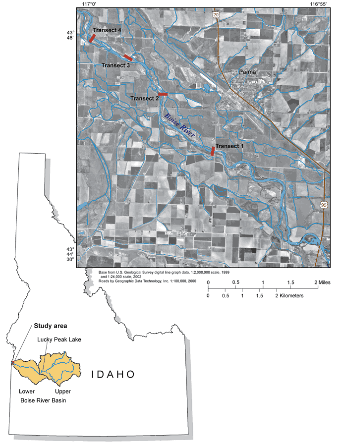
Figure 1. Location of study area in the Lower Boise River, Canyon County, Idaho.
For more information about USGS activities in Idaho, visit the USGS Idaho Water Science Center home page .

![]() U.S. Department of the Interior |
U.S. Geological Survey
U.S. Department of the Interior |
U.S. Geological Survey
Persistent URL: https://pubs.water.usgs.gov/sir
Page Contact Information: Publications Team
Page Last Modified:
