Scientific Investigations Report 2005-5227
U.S. GEOLOGICAL SURVEY
Scientific Investigations Report 2005-5227
The SVRP study area has undergone a complex series of geologic events that have resulted in the surface and subsurface geologic framework that exists today. A basic understanding of these geologic events and the general order in which they occurred is helpful in understanding the occurrence of ground water in the study area. A simplified geologic time scale (table 1) is provided to aid the reader in understanding the sequence of geologic events and the magnitude of geologic time over which they occurred.
Descriptions of the region’s geologic history are available at various levels of detail in numerous documents listed in the “Selected References” section of this report. The summary that follows is based in part on descriptions contained in Conners (1976), McKiness (1988a), Molenaar (1988), Adema (1999), Breckenridge and Othberg (2001), Kiver and Stradling (2001), and Lewis and others (2002).
In this report, a simplified geologic history is described for three major time periods. The pre-Tertiary geology includes mostly Precambrian sedimentary rocks that have been metamorphosed and disrupted in places by igneous intrusions. The Tertiary geology includes the Columbia River basalts and interbedded lacustrine deposits of the Latah Formation. The Quaternary geology includes mostly glacial and interglacial deposits of varying grain size that overly the older rocks.
The oldest rocks in the region surrounding and underlying the SVRP aquifer study area are metamorphosed, fine-grained sediments that were originally deposited in a large, shallow north-south trending marine basin during the Precambrian Era. These rocks are in outcrop today as low-grade metasedimentary rocks including argillite, siltite, and quartzite, which grade locally into more highly metamorphosed schists and gneisses.
Following deposition and metamorphism, as much as 20,000 ft of the Precambrian rocks were eroded before the Paleozoic Era began (Conners, 1976). During the Cambrian, additional sedimentation occurred in shallow seas that resulted in shale, limestone, and sandstone being deposited over the Precambrian rocks. However, from the end of Cambrian time to the present, the region mostly has been emergent and much of the post-Cambrian sediments have been eroded from the area leaving few surface exposures. Emplacement of various igneous intrusive bodies, along with associated metamorphism and deformation, occurred over a long time between the Jurassic and Tertiary. During the Cretaceous, faulting and emplacement of large granitic bodies resulted in the formation of the north-south trending Purcell Trench, a geomorphically low feature, that extends from north of the Canadian Border south to the Rathdrum Prairie (pl. 2). Approximate fault locations in the study area, from Zientek and others (2005), are shown on plate 2. Movement on faults mapped within the SVRP aquifer extent (pl. 2) ended by Miocene time when drainages in the area were invaded by Columbia River basalt (Lewis and others, 2002).
In pre-Tertiary time, the region’s surface-water drainage was from a vast area to the north and east of the SVRP study area. Streams flowed southward from the Purcell Trench and Clark Fork Valley into presumably a large river that flowed through the Rathdrum Prairie and then westward through the Spokane Valley to the ancient Columbia River. The pre-Tertiary landscape was characterized by ridge crests and valley bottoms with considerable relief, probably 4,000 ft or more in places (Molenaar, 1988).
During the Miocene, basalt flows of the Columbia River Group spread northeastward from the Columbia Plateau, filling the deep canyons of the pre-Tertiary landscape. Drainage systems that previously transported sediment out of the area, now deposited their sediment at the margins of the basalt flows. Early Miocene basalt flows dammed drainages, including the ancient Rathdrum–Spokane River, creating lakes in which sand, silt, and clay of the Latah Formation were deposited. The Latah sediments consist predominantly of lacustrine silt and clay, with some fluvially deposited sand and gravel units (McKiness, 1988a). The older basalt flows likely did not extend to the eastern and northern Rathdrum Prairie and a relatively thick section of sediment accumulated in those areas. Late Miocene basalt flows eventually overrode the entire Rathdrum Prairie region, creating alternating layers of basalt and Latah Formation interbeds, as recorded in drillers’ logs for wells in the northeastern Rathdrum Prairie (Hammond, 1974).
During a period of slow downcutting from the Late Miocene to the Early Pleistocene, as much as 590 ft of Latah sediments were removed from the region (Anderson, 1927). Streams in the developing drainages eroded much of the exposed Latah beds and some of the younger basalt near the margins of the basin. Accurate estimates of thickness and extent of the remaining Latah sediments are difficult to determine due to the cover of Pleistocene drift and a scarcity of boreholes that penetrate below the water table. Anderson (1940) discovered a 980 ft thick bed of Latah Formation below an exposed basalt flow when drilling a well west of Hayden Lake.
Late Tertiary landscape likely was characterized by the ancient Spokane—Rathdrum River following a course similar to today’s Spokane River except in north Spokane where the river’s course probably followed the Hillyard Trough on the east side of the basalt plateau of Fivemile Prairie (Newcomb and others, 1953). The river then flowed west along the present reach of the Little Spokane River valley toward the present main valley near Long Lake. Tertiary sediments associated with this ancient river may occur at depth along its historic course, now buried by Pleistocene drift.
Table 1. Geologic timescale with simplified geologic units of the study area.
[Modified from http://geology.er.usgs.gov/paleo/geotime.shtml and http://www.geosociety.org/science/timescale/timescl.htm, accessed February 8, 2005. Abbreviations: –, indicates a gap in the geologic record resulting from erosion and (or) nondeposition]
| Phanerozoic Eon (544 million years ago to present) | Cenozoic Era (65 million years ago to present) | Quaternary Period (1.8 million years ago to present) | Holocene Epoch (8,000 years ago to present) | Recent non-glacial sediment |
| Pleistocene Epoch (1.8 million to 8,000 years ago) | Glacial deposits and catastrophic flood deposits | |||
| Tertiary Period (65 to 1.8 million years ago) | Pliocene Epoch (5.3 to 1.8 million years ago) | – | ||
| Miocene Epoch (23.8 to 5.3 million years ago) | Basalt and older sediments | |||
| Oligocene Epoch (33.7 to 23.8 million years ago) | – | |||
| Eocene Epoch (55.5 to 33.7 million years ago) | Intrusive igneous rocks | |||
| Paleocene Epoch (65 to 55.5 million years ago) | ||||
| Mesozoic Era (248 to 65 million years ago) | Cretaceous Period (145 to 65 million years ago) | |||
| Jurassic Period (213 to 145 million years ago) | – | |||
| Triassic Period (248 to 213 million years ago) | ||||
| Paleozoic Era (544 to 248 million years ago) | Permian Period (286 to 248 million years ago) | |||
| Carboniferous Period (360 to 286 million years ago) | ||||
| Devonian Period (410 to 360 million years ago) | ||||
| Silurian Period (440 to 410 million years ago) | ||||
| Ordovician Period (505 to 440 million years ago) | ||||
| Cambrian Period (544 to 505 million years ago) | Sedimentary rocks | |||
| Precambrian Time (4,500 to 544 million years ago) | Proterozoic (2,500 to 544 million years ago) | Metamorphic rocks | ||
| Archean (3,800 to 2,500 million years ago) | – | |||
| Hadean(4,500 to 3,800 millionyears ago) |
During the Pleistocene Epoch as the Earth’s climate experienced warming and cooling periods, the study area repeatedly was subjected to erosional and depositional processes associated with glacial and interglacial periods. Although as many as six major glaciations affected the region, only the most recent can be described with any level of certainty. Sediments from earlier periods are encountered locally in some wells, but little surface evidence remains to reconstruct their depositional history.
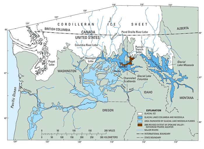
During the climax of the most recent Pleistocene glaciation (about 15,000 years before present), much of northern Washington, Idaho, and westernmost Montana, was covered by lobes of the Cordilleran ice sheet (fig. 4). The large ice sheet formed in the mountains of British Columbia and flowed south, filling valleys and overriding low mountain ranges in the northern parts of Washington, Idaho, and Montana. The Pend Oreille River and Purcell Trench lobes contributed vast quantities of sediment into the study area via melt-water streams from the glacial lobes. The Okanogan and Columbia River lobes influenced the SVRP study area by occasionally blocking westward drainage of the ancestral Columbia and Spokane Rivers and creating large ice-age lakes. Glacial Lake Columbia (fig. 4) was created when the Okanogan Lobe blocked the ancestral Columbia River (Waitt and Thorson, 1983).
The Purcell Trench lobe in northern Idaho blocked the drainage of the ancestral Clark Fork River in northwestern Montana and created Glacial Lake Missoula (fig. 4). Glacial Lake Missoula had a maximum surface elevation of about 4,200 ft, a maximum depth of about 2,000 ft, and a maximum surface area of about 3,000 mi2. Catastrophic failure of the Clark Fork ice dam released as much as 500 mi3 of water at a rate 10 times the combined flow of all the present-day rivers on earth. The torrent of flood water crossed the states of Montana, Idaho, Washington, and Oregon before reaching the Pacific Ocean. The continuous southward flow at the ice front repeatedly blocked the Clark Fork River and refilled Lake Missoula. This cycle was repeated as many as 100 times (Atwater, 1986) until the end of the last glaciation. The largest of the Missoula floods, many of which probably occurred relatively early in the lake-filling and flooding cycle, overwhelmed local drainages and topped the 2,400-ft divide west of Spokane and spilled southward towards Cheney and beyond, creating the Channeled Scablands (fig. 4). Smaller floods that made their way through the Rathdrum Prairie and Spokane River Valley likely discharged through lower elevation drainages including the present day Little Spokane River, Long Lake, and Hangman (Latah) Creek (pl. 1).
The southern end of Lake Pend Oreille at Farragut State Park marks the location of the outbreak of these floods (pl. 1). Most of the flood waters flowed south through the Rathdrum Prairie area and then westward toward the Spokane area. Flood deposits are mostly composed of gravels of glaciofluvial origin derived from glacial outwash of the Purcell Trench Lobe and reworked by flood events. Near-surface deposits include coarser gravels located centrally in the valley, with finer sands and gravels along the margins. Flood bars of these deposits are along the valley margins and dam the outlets of Spirit, Twin, Hayden, Coeur d’Alene, Liberty, and Newman Lakes.
Glacial Lake Columbia was another large lake impounded by an ice dam, created by the Okanogan Lobe, and was the largest glacial lake in the path of the Missoula floods (fig. 4). This lake was long-lived (2,000-3,000 years) and its surface altitudes typically were 1,640 ft but reached 2,350 ft during maximum blockage by the Okanogan Lobe and increased as high as 2,460 ft during floods from Glacial Lake Missoula (Atwater, 1986). Glacial Lake Columbia’s higher level likely occurred early in glacial time, whereas, the lower and more typical lake level was later (Richmond and others, 1965; Waitt and Thorson, 1983; and Atwater, 1986). At the lower level (1,640 ft), Glacial Lake Columbia extended eastward to the Spokane area, where clayey lake sediment is intercalated with Missoula flood sediment (Waitt and Thorson, 1983). At the higher level of Glacial Lake Columbia (2,350 ft), the Rathdrum Prairie would have been flooded to within a few miles of the Purcell Trench Lobe that dammed Glacial Lake Missoula.
((Modified from Allen and Burns, 1986, and Atwater, 1986).
Sedimentation associated with Glacial Lake Columbia resulted in thick, fine-grained sediments throughout much of the region. Clay and silt deposits in the study area, presumed to be Glacial Lake Columbia sediments, have been recorded in drilling records for deep boreholes in the Hillyard Trough and north Spokane areas, and in the Hangman (Latah) Creek Valley. At least 16 beds of Glacial Lake Missoula flood deposits have been identified within Glacial Lake Columbia deposits in the Hangman (Latah) Creek Valley, just south of Spokane (Waitt and Thorson, 1983). These fine-grained deposits generally occur at depth beneath late glacial deposits of the Missoula floods and likely occur elsewhere in the study area. Alternating beds of lake and flood deposits may occur at considerable depth (400-600 ft) throughout parts of the study area.
Although Glacial Lake Columbia apparently inundated most of the SVRP study area at least periodically, the last of the Missoula floods may have come through an area devoid of a glacial lake. From the Spokane River Valley to its confluence with the Columbia River 65 mi downstream, a complex of flood bars are present that develop only when standing water is very shallow or absent (Kiver and Stradling, 2001). The present surface morphology of the Rathdrum Prairie and Spokane River Valley developed during the last outburst floods between 13,000 and 11,000 years ago (Waitt, 1985). These late glacial deposits comprise much of the upper part of the SVRP aquifer.
Recent surficial geologic mapping is available for most of the SVRP area and was compiled for this study (pl. 2, table 2) based on original mapping by Derkey (1997), Breckenridge and Othberg (1998a, b; 1999a, b; 2000, 2004), Derkey and others (1998, 1999, 2003, 2004a-d), Lewis and others (2002), and Hamilton and others (2004). Surficial geologic mapping is needed but not currently available in southern Bonner County near the southern outlet of Spirit and Hoodoo Valleys. Detailed surficial geologic mapping in the southern areas shown on the Blanchard, Careywood, Cocolalla, and Edgemere 7.5 minute quadrangles would greatly improve the understanding of shallow sediment along the upstream extent of the SVRP aquifer.
[State: ID, Idaho; WA, Washington. Section orientation: ESE, east, southeast; NE, northeast; N-S, north-south; NW, northwest; NW-SE, northwest-southeast; SE, southeast; SSW-NNE, south, southwest-north, northeast; SW, southwest; SW-NE, southwest-northeast; WE, west-east; WNW, west, northwest. Abbreviations: USGS, U.S. Geological Survey]
| USGS quadrangle name(s) | Scale | State | Name of section(s) published with map in study area | Section orientation | Notes | Reference |
|---|---|---|---|---|---|---|
| Coeur d’Alene | 1:24,000 | ID | Southeast Rathdrum Prairie | Breckenridge and Othberg, 1999b | ||
| 1:100,000 | ID | A-A´ | WNW-ESE | Quaternary sediments undifferentiated on section A-A´ | Lewis and others, 2002 | |
| Fernan Lake | 1:24,000 | ID | Eastern edge of Rathdrum Prairie | Breckenridge and Othberg, 2004 | ||
| Hayden | 1:24,000 | ID | Central Rathdrum Prairie | Breckenridge and Othberg, 1999a | ||
| Hayden Lake | 1:24,000 | ID | Unnamed schematic section, not to scale | W-E | Eastern edge of Rathdrum Prairie | Breckenridge and Othberg, 2000 |
| Post Falls and Liberty Lake (ID portion) | 1:24,000 | ID | Unnamed schematic section, not to scale | N-S | Southwest Rathdrum Prairie, Post Falls | Breckenridge and Othberg, 1998a |
| Rathdrum and Newman Lake (ID portion) | 1:24,000 | ID | Unnamed schematic section, not to scale | N-S | Southwest Rathdrum Prairie, Newman Lake | Breckenridge and Othberg, 1998b |
| Airway Heights | 1:24,000 | WA | Western edge of aquifer | Derkey and others, 2004a | ||
| Dartford | 1:24,000 | WA | B-B´ | SSW-NNE | Downstream extent of aquifer | Derkey and others, 1998 |
| Greenacres | 1:24,000 | WA | A-A´ B-B´ |
N-S N-S |
Spokane valley | Derkey and others, 2004b |
| Mead | 1:24,000 | WA | D-D´ I-I´ |
NW-SE W-E |
Downstream extent of aquifer | Derkey, 1997 |
| Newman Lake and Liberty Lake (WA portions) | 1:24,000 | WA | A-A´ B-B´ C-C´ |
W-E N-S N-S |
Outlet of Newman Lake Spokane valley | Derkey and others, 2004d |
| Nine Mile Falls | 1:24,000 | WA | Downstream extent of aquifer | Derkey and others, 2003 | ||
| Spokane NE and Spokane SE | 1:24,000 | WA | A-A´ | N-S | Spokane valley | Derkey and others, 1999 |
| Spokane NW | 1:24,000 | WA | A-A´ B-B´ |
SW-NE SSW-NNE |
Central Spokane | Derkey and others, 2004c |
| Spokane SW | 1:24,000 | WA | A-A´ | SW-NE | Hangman (Latah) Creek | Hamilton and others, 2004 |
The surficial geology of the SVRP study area consists of 11 geologic units described below and are shown on the surficial geologic map (pl. 2).
Undifferentiated glacial and alluvial deposits (Qu): Pleistocene glacial or glaciofluvial deposits and Holocene alluvium in the northern part of the study area where recent deposits have not been differentiated in Bonner County, Idaho.
Recent non-glacial sediment (Qs): mostly Holocene sediment including alluvium in stream channels, lacustrine deposits associated with study area lakes, mass-wasting deposits most commonly detected along the base of basalt bluffs in Spokane County, peat associated with poorly drained and organic rich areas, and wind-blown deposits on the surface of prairies and the basalt plateaus.
Glacial outwash and till (Qot): includes late Pleistocene glacial outwash and minor till near the southern end of Lake Pend Oreille, Idaho, that postdates the older Missoula flood deposits. The outwash consists of very coarse boulder gravels with sand deposited by meltwater streams from either overflow of the Lake Pend Oreille basin during Cordilleran deglaciation of the Purcell Trench, or from noncatastrophic drainage of Glacial Lake Missoula. At the southern end of Lake Pend Oreille, the unit consists of bouldery clay till and boulder outwash deposits that form a modified end moraine.
Glacial lake deposits (Qgl): includes glaciolacustrine deposits of Glacial Lake Columbia. The unit is composed of silt and fine sand, with clay interbeds, scattered boulders, and some sand and gravel lenses. In the study area, this unit is mapped along Deadman and Hangman (Latah) Creeks, Washington. In areas, especially along Hangman (Latah) Creek, the unit is interbedded with glacial-flood deposits.
Catastrophic flood deposits, gravel (Qfg): includes flood deposits from catastrophic draining of Glacial Lake Missoula that are a mixture of boulders, cobbles, pebbles, and sand with lenses of sand and silt. These deposits occur from near the outlet of Lake Pend Oreille through the Rathdrum Prairie and the Spokane River Valley.
Catastrophic flood deposits, sand (Qfs): includes flood deposits from catastrophic draining of Glacial Lake Missoula that are predominantly sand with sparse pebbles, cobbles, and boulders. Exposures of the unit mapped in Washington are believed to be sediment that was deposited when outburst floods flowed into a high stand of Glacial Lake Columbia. These deposits are most widespread in the Hillyard Trough and areas west of Five Mile Prairie, Washington. Smaller exposures are mapped along the SVRP aquifer boundaries near the Washington–Idaho state line where the unit consists of sand and silt with some gravel that was mostly deposited in waning floodwaters.
Older sediments (Ts): includes the Latah Formation, which is composed of lacustrine and fluvial deposits of siltstone, claystone, and minor sandstone. The unit generally is gray or tan except in more weathered areas where it is brownish yellow or orange. The unit is interbedded in places with the Columbia River basalt.
Basalt (Tb): includes the Columbia River basalts, which are fine-grained dark gray, greenish gray, or black basalt. Surface exposures of the unit are common in upland areas surrounding the SVRP aquifer in Washington. In Idaho, the largest exposures are near Coeur d’Alene and Hayden Lakes.
Intrusive igneous rocks (TKg): includes Cretaceous to Eocene granite and orthogneiss. Surface exposures occur throughout much of the study area in the upland areas.
Sedimentary rocks (Єs): composed of Cambrian limestone, shale, and quartzite with a very limited exposure in the study area near the southern end of Lake Pend Oreille.
Metamorphic rocks (pЄm): consists of Precambrian metasedimentary rocks including argillite, siltite, and quartzite. Surface exposures of the unit occur throughout the highland areas of the eastern two-thirds of the study area.
Bedrock, which includes the Precambrian to Tertiary metamorphic and intrusive igneous rocks and Tertiary basalt and their interbeds, underlies and laterally bounds the SVRP aquifer. These rocks are generally low permeability units, and as such, generally produce small amounts of water and are not considered major aquifers within the SVRP study area. The crystalline structure of the metamorphic and intrusive igneous rocks generally inhibits their ability to store and transmit water. However, weathered or fractured zones within these rocks can transmit usable amounts of ground water. Similarly, the basalts and their interbeds, can produce significant discharges for domestic use, but are discontinuous and not considered important aquifers within the study area.
Except along the SVRP aquifer margins where some wells penetrate unconsolidated deposits and reach bedrock, the buried bedrock surface configuration is unknown. No known wells penetrate the entire thickness of these deposits in the area between Lake Pend Oreille and Spirit Lake, and to the south in the central Rathdrum Prairie, or in the Hillyard Trough. Few wells penetrate the entire thickness of deposits in the Spokane Valley.
Numerous geophysical investigations have been conducted to determine the configuration of the base of the SVRP aquifer using several surface geophysical methods to investigate the subsurface characteristics of deposits and bedrock, including seismic refraction (Newcomb and others, 1953, Tanaka, 1975, Dion and Sumioka, 1991, HartCrowser, 2003), seismic reflection (SeisPulse Development Corporation and others, 1993; Gerstel and Palmer, 1994; Palmer and Gerstel, 1994; Palmer and others, 1995a, b; CH2M HILL, 1998, 2000a; and S. Palmer, Washington Department of Natural Resources, written commun., 2005), and gravity (Purves, 1969; Hammond, 1974; and Adema, 1999).
Although most of these studies were intended to better define the bedrock configuration at depth, it should be noted that this bedrock surface is not necessarily the base of the aquifer as is sometimes reported or assumed. In places, the bottom of the aquifer is marked by the contact of coarse aquifer sediment with much finer-grained clay and silt beneath it. The extent of fine-grained deposits beneath the aquifer generally is unknown except in wells along some parts of the aquifer margin where drillers’ logs report fine-grained sediment beneath the aquifer.
Additional caution should be used when comparing the estimated depths to bedrock presented in these geophysical studies because ”bedrock” is defined differently by different investigators, presumably based on the goals of the investigation and limitations of the methods employed. This is an important distinction to keep in mind when comparing these investigation results where the phrase “depth to bedrock” has been used with the following meanings: (1) depth to the crystalline bedrock including pre-Tertiary metamorphic and intrusive igneous rocks; (2) depth to sedimentary deposits of the Latah Formation and Columbia River basalts; or (3) depth to Columbia River basalts and crystalline bedrock excluding the Latah Formation.
A brief summary of surface geophysical studies completed as of 2004 is provided in this report. No attempt has been made to evaluate methods used or investigation results or to compare appropriateness of one surface geophysical method over another. Approximate locations of surface geophysical transects from investigations that report estimated depths to bedrock along profiles in the SVRP study area are shown on plate 2.
Newcomb and others (1953) completed two seismic refraction profiles near Spokane in 1951 in an effort to locate the base of the glacial-outwash aquifer, determine the type of materials underlying the aquifer, and locate the crystalline bedrock of the ancestral valley. One section trended north-south across the Spokane Valley east of the Washington–Idaho state line; the other trended east-west across the Hillyard Trough in northeast Spokane (pl. 2). Five units were identified in their refraction: 1) soil and subsoil of the glacial outwash; 2) unsaturated glacial outwash; 3) saturated glacial outwash; 4) Latah Formation with intercalated igneous rocks; and 5) granitic rock. In the state-line area, Newcomb and others (1953) interpreted the central and deepest part of the v-shaped ancestral valley floor to be granitic rock about 1,280 ft below present-day land surface, with 340 ft of primarily glacial and glaciofluvial deposits overlying 940 ft of Latah Formation with intercalated basalt. Along the transect that crosses the Hillyard Trough, Newcomb and others (1953) mapped a slightly undulating granitic bedrock surface with the deepest part being about 860 ft below present-day land surface, with 310 ft of glacial and glaciofluvial deposits overlying 550 ft of Latah Formation.
Tanaka (1975) reports similar results as Newcomb and others (1953) for the state-line and Hillyard Trough areas, as well as two additional seismic refraction profiles used to determine depth to crystalline and metamorphic bedrock. A northeast-southwest profile from the base of Five Mile Prairie across the Spokane River indicates that bedrock is over 880 ft below land surface near the river in sec.28, T.26 N., R.42 E. A second northeast-southwest profile, in the Little Spokane River Valley, shows that bedrock is less than 300 ft below land surface beneath the river in sec.3, T.26 N., R.42 E. Details of this work were unavailable in the abstract that describes the results (Tanaka, 1975).
Dion and Sumioka (1991) describe the results of seismic refraction profiles conducted north of Pasadena Park in Spokane as part of an investigation to document extent and source of organic solvents in ground water. Although site-specific in nature and outside the SVRP aquifer boundary, this study illustrates how this and other tributary valleys contain ground water that is hydraulically connected to the SVRP aquifer. Cross sections shown in the report indicate a depth to bedrock of 30 to more than 130 ft, based on geophysical transects and drilling records.
In 1994, S.D. Schwarz and Associates (in HartCrowser, 2003, Appendix O) conducted a seismic refraction survey at the Kaiser Trentwood Facility south of Trentwood in the Spokane Valley. The purpose of the survey was to define the depth and configuration of the ground water surface and underlying bedrock at selected locations beneath the facility. In the investigation, bedrock was defined as pre-Tertiary metamorphic complex (HartCrowser, 2003). Although the presence of Columbia River basalt and the Latah Formation was not reported during installation of wells at the site, it was reported that these units may be present at depth and probably would occur as discontinuous erosional remnants over bedrock and below the base of the glacial and flood deposits. Three 1,500 ft seismic refraction lines at the site yielded an approximate depth to bedrock ranging from 200 to 350 ft below ground surface (HartCrowser, 2003).
In the early- to mid-1990s, the Washington Department of Natural Resources, SeisPulse Development Corporation, and Spokane County tested and conducted shallow seismic reflection studies using a new impulsive seismic source (SeisPulse Development Corp., and others, 1993; Palmer and Gerstel, 1994; Gerstel and Palmer, 1994; and Palmer and others, 1995a). This work was done primarily to define the bedrock reflection beneath the SVRP aquifer in the Spokane Valley (SeisPulse Development Corp., and others, 1993).
When comparing a shallow seismic reflection profile conducted near the Washington–Idaho state line (Palmer and Gerstel, 1994) with Newcomb and others (1953) transect near the same location, it appears that in the more recent investigation bedrock may be defined as including the Latah Formation, whereas, Newcomb and others (1953) differentiated the Latah Formation and associated Columbia River basalt as a separate unit from the underlying crystalline “granitic” bedrock. The seismic reflection data for the state-line area transect of Palmer and Gerstal (1994) show that bedrock is 450 to 550 ft below land surface. Newcomb and others (1953) reported that depths to the Latah Formation ranged from 350 to 500 ft below ground surface in the same area. A north-south profile shot west of Otis Orchards (Palmer and others, 1995a), resulted in a calculated depth to bedrock greater than 500 ft in the center of the main valley.
As part of the city of Spokane’s Wellhead Protection Program, SeisPulse Development Corporation did seismic reflection profiling along 10 transects in September 1994 (CH2M HILL, 1998, Appendix G). This work was done to examine bedrock characteristics in the area between Spokane Falls and Five Mile Prairie and to refine the apparent aquifer thickness along the eastern edge of the city. Reported depths to bedrock ranged from about 250 to 340 ft along the north-south transect through the Trinity Trough and from about 260 to 520 ft along the north-south transect near Parkwater. The composition of the bedrock was not noted in CH2M HILL, 1998.
Shallow seismic reflection profiling also was done for the Spokane Aquifer Joint Board Wellhead Protection Program in 1996 to define aquifer thickness and bedrock topography in the Spokane Valley area between Pines Road Knoll and the community of Greenacres (CH2M HILL, 2000a, Appendix F). In this investigation, ”bedrock” was defined as both Columbia River basalt and older granitic gneiss (CH2M HILL, 2000a, Appendix F). The seismic reflection data indicate the presence of a strong reflector thought to represent the top of bedrock in contact with glaciofluvial and alluvial valley fill deposits. It is not known, however, whether the valley fill materials at depth have a similar water-bearing capacity to the upper part of the aquifer (CH2M HILL, 2000a). The 5-mi long north-south transects across the Spokane Valley, indicated a valley-like bedrock profile, with its deepest point, about 600 ft from land surface to bedrock, near present-day Spokane River (CH2M HILL, 2000a).
In Idaho, the Washington Department of Natural Resources and SeisPulse Development Corporation conducted seismic reflection profiling between the southern ends of Twin Lakes and Round Mountain in the early-1990s (S. Palmer, Washington Department of Natural Resources, written commun., 2005). At the east end of the transect, water wells completed in granitic bedrock provided good control on the depth to bedrock, which ranged from 220 to 260 ft. A velocity survey was done in a nearby well to convert the seismic reflection travel time to depth, and the reflection data indicated a 240 ft depth to bedrock (S. Palmer, Washington Department of Natural Resources, written commun., 2005). The resulting basin profile is deeper on its west side, with a maximum depth of 550-600 ft beneath Highway 41 (S. Palmer, Washington Department of Natural Resources, written commun., 2005). The seismic reflection profile indicates bedrock becomes shallow west of Highway 41 to the end of the profile, which is about 1,000 ft east of the southern end of Twin Lakes.
Purves (1969) conducted a gravity survey throughout the Spokane Valley and adjoining western part of the Rathdrum Prairie. Purves used the supposition that, in a relatively simple geologic system, the Bouguer gravity field generally mimics the underlying bedrock configuration. This buried bedrock configuration was determined through density contrasts between the bedrock and the overlying unconsolidated material. Although estimates of actual depth to bedrock were not feasible at the time, Purves work has proved useful in indicating the shape of the buried bedrock surface. A significant finding of Purves’ (1969) was the existence of a probable west-northwest trending subsurface drainage divide within the Rathdrum Prairie basin about 2 mi west of the Washington–Idaho state line. East of this divide, in the Rathdrum Prairie, Purves reported that the subsurface configuration appeared to be dominantly influenced by glacial erosion, with the u-shaped trough filled almost exclusively with glacial and flood deposits and minimal basalt. His survey was inconclusive as to the existence of Latah Formation in the Rathdrum Prairie section and he reported that, “To surmise the presence or absence of the Latah Formation strains the capabilities of gravity interpretation” (Purves, 1969). West of the divide, in the Spokane Valley section of the aquifer, Purves reported that the basement configuration appeared to be a fluvially dissected erosional valley with erosional terraces composed of either a complex basement or basalt.
Hammond (1974) published gravity survey results of a study done in 1969 in northern Rathdrum Prairie to help refine previous estimates of underflow moving toward the Rathdrum Prairie from the Athol area and to quantify water being recharged to the aquifer by Lake Pend Oreille. A detailed gravity survey was done to define the configuration of the pre-Tertiary bedrock surface and to calculate the thickness of the unconsolidated material from the southern end of Lake Pend Oreille south to the West (Main), Middle (Ramsey), and Chilco Channels. Few details regarding the methods used and transect locations are included in the report, but resultant contours of the buried pre-Tertiary bedrock surface indicate that the greatest depth to bedrock is in the West (Main) Channel and is more than 1,400 ft below the present-day land surface (Hammond, 1974). Because the work reported by Hammond (1974) provides only a pre-Tertiary bedrock surface (metamorphic and intrusive igneous rocks), the presence or absence of the Latah Formation and Columbia River basalt remains unknown.
Building on previous seismic and gravity geophysical investigations, Adema (1999), modeled 5 geologic cross-sections of the Rathdrum Valley profile by using 630 gravity measurements, 146 of which were newly collected to complement existing data. For modeling purposes, Adema grouped materials of similar densities: metamorphic and intrusive igneous rocks, and the Miocene basalts were all grouped and referred to as bedrock; Latah Formation, flood deposits, and intermingled sands and clays were modeled and referred to as sediment. The modeled data show a generally smooth valley floor, with an incised channel in the western part of the Rathdrum Prairie. Adema’s interpretation suggests an approximate sediment thickness of more than 1,150 ft between Post Falls and Rathdrum. Although Adema’s work provides a valuable update on the bedrock depth and morphology of the Rathdrum Prairie, estimating the actual thickness of the SVRP aquifer was beyond the limits of the gravity study. As stated in Adema’s report, no attempt was made to identify specific hydrologic boundaries within the sediments, as such divisions would be overwhelmingly subjective due to the low density contrasts involved (Adema, 1999).
During the Spokane Aquifer Joint Board Wellhead Protection Program, a microgravity gradiometry survey was done in the northwestern end of the Hillyard Trough to determine the sediment thickness and the basement topography where lithologic conditions were reported to limit the application of seismic reflection methodologies (CH2M HILL, 2000a, Appendix G). Microgravity surveys provide increased resolution of near-surface structures over standard gravity methods. The north Hillyard Trough area warranted additional study due to limited evidence of a deep, confined aquifer separated from the upper SVRP aquifer by low-permeability glacial lake deposits (CH2M HILL, 2000a). Results of the 2-mi long southwest-northeast trending transect indicate a depth to bedrock at about 490 to 590 ft in this area (CH2M HILL, 2000a).
For more information about USGS activities in Washington, visit the USGS Washington District home page .

![]() U.S. Department of the Interior |
U.S. Geological Survey
U.S. Department of the Interior |
U.S. Geological Survey
URL: https://pubsdata.usgs.gov/pubs/sir/2005/5227/section5.html
Page Contact Information:
Page Last Modified: Thursday, 01-Dec-2016 18:45:50 EST
