Scientific Investigations Report 2005-5255
U.S. GEOLOGICAL SURVEY
Scientific Investigations Report 2005-5255
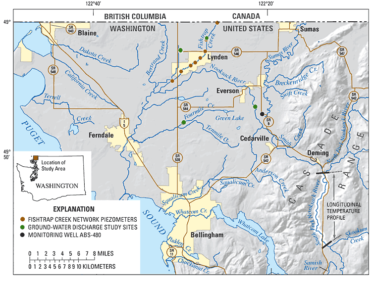
A series of studies have documented the occurrence of elevated concentrations of fecal bacteria and nitrate in lowland streams of Whatcom County, Washington. These and other water-quality issues have created significant challenges for water-resources managers in the lower Nooksack River basin of Whatcom County (fig. 1). Because additional sources of fresh water are not readily available in this area, balancing the competing demands for water resources in this region is of great concern to the public and a high priority to local water-resources managers. In addition, water-resource allocations have been implemented by State regulation of instream flows (Chapter 173-501 WAC) as a result of the Endangered Species Act and the listing of Chinook salmon and Bull trout as "threatened species." An improved understanding of how ground water and surface water interact in the area will greatly assist water-resources managers in making decisions that result in improved water quality.
The quality of surface water and ground water in the lower Nooksack River basin has been degraded. Land use is predominantly rural agriculture; however, there is persistent encroachment of residential development from nearby population centers. The Washington State Department of Ecology maintains a list of impaired waters as directed under the Clean Water Act section 303(d). The 1998 303(d) list is the most recent list approved by the Environmental Protection Agency and includes numerous stream reaches in the lower Nooksack River basin that are listed primarily for fecal coliform contamination. In streams that have been intensively monitored, elevated fecal coliform and nitrate concentrations occur throughout the year (Embrey and Frans, 2003). Nitrate contamination of ground water is widespread in the shallow glacial aquifer, which supplies drinking and irrigation water for about 60,000 people (Kaluarachchi and Almasri, 2002). Although precipitation is plentiful in this region, it occurs unevenly throughout the year, resulting in winter-time periods of standing water and summer-time periods of soil-moisture deficits. During the summer low-flow periods, available surface water is insufficient to meet demands for agricultural crop irrigation, potable water supplies, and maintenance of in-stream flows for fish habitat.
Recent monitoring shows the widespread occurrence of fecal coliform bacteria in lowland streams (Embrey, 2001; Northwest Indian College, 2004). The human health hazards associated with fecal coliform exposure have resulted in the closures of shellfish beds in Puget Sound near Bellingham and the posting of warnings at recreational areas. The economic impact of such closures has focused attention on various sources of contamination. Previous studies (Erickson, 1995; Joy, 2000) did not conclusively establish a link between the concentration of fecal coliform in the mainstem of the Nooksack River, and the corresponding streamflow-discharge response due to rainfall-runoff events. These studies found that the concentrations of fecal coliform did not decrease along the downstream length of the river, suggesting that either attenuation of fecal coliform was not occurring or that there was a persistent source of fecal coliform along the length of the river. This lead to the hypothesis that ground water may be a source of fecal coliform in lowland streams during the late summer base-flow period, when discharging ground water is the primary source of water in those streams. Alternatively, manure application practices, overland flow, and discharge from tile drains also may provide significant pathways for transport of bacteria to surface water. These alternate pathways and their relative importance need to be better understood for effective management measures to improve surface-water and ground-water quality.
Discharging ground water that provides nutrients to streams also is of concern to water managers and local residents. Nutrients in discharging ground water could lead to excessive in-stream plant growth and biomass production that in turn leads to high biological and chemical oxygen demands, which depletes dissolved oxygen available for fish and other aquatic organisms. Numerous studies have documented concentrations of nitrate as nitrogen in ground water consistently greater than 10 mg/L in parts of Whatcom County. Nitrate contamination is extensive and present to some extent in virtually all parts of the surficial aquifers of the Nooksack River lowland (Garland and Erickson, 1994; Inkpen and others, 2000; Kaluarachchi and Almasri, 2002) and British Columbia (Liebscher and others, 1992; Gartner-Lee, 1993; Hii and others, 1999). Concentrations of nitrate as nitrogen greater than 10 mg/L exceed the U.S. Environmental Protection Agency drinking-water standard and thus limit the suitability of ground water for use as a source of domestic and municipal water supply.
Nitrate concentrations in ground water have been steadily increasing in many parts of the study area for more than 20 years (Kaluarachchi and Almasri, 2002). They are expected to continue to increase because the application of fertilizer and manure in Whatcom County has increased as much as 50-fold since 1945. Manure application to forage production fields that are part of farm nutrient management plans supplies a major, long-term source of nitrates in ground water (Carey, 2002). More than 20 percent of water supply wells sampled in the Sumas-Blaine aquifer (Erickson, 1998) contained nitrate concentrations that exceeded the U.S. Environmental Protection Agency 10 mg/L standard for drinking water supplies. The effectiveness of management strategies in the reduction of nitrate in ground water would benefit from a more detailed understanding of the processes affecting fate and transport of nitrate in the lower Nooksack River basin.
This report describes the results of a study to:
Knowledge gained from this study is expected to enable more effective management and implementation of measures designed to decrease nitrate and fecal-bacteria concentrations in ground water and prevent contamination from reaching surface water. The specific objectives of this study are to:
An additional objective was added after reconnaissance sampling indicated that little if any fecal bacteria concentrations would be present in discharging ground water. This additional objective was to determine the attenuation or rate of die-off of fecal bacteria associated with the surface-water bed sediments.
The Nooksack River lowland encompasses the area from the Cascade foothills to the Puget Sound and from Bellingham to the Canadian border (fig. 1). Surface features within this lowland area include glacial outwash plains, hummocky uplands, and alluvial flood plains (Cox and Kahle, 1999). Two major forks of the Nooksack River join near the town of Deming where the mainstem of the Nooksack River emerges from the foothills of the Cascade Range to flow across the lowland. The Nooksack River has eroded and cut down through the glacial outwash plain as it flows generally westward toward the Puget Sound. Numerous tributary streams drain the lowland area and flow into the Nooksack River at various points.
The principal aquifer in the lower Nooksack River basin is the Sumas aquifer, which provides water for residential, agricultural, and industrial needs (Cox and Kahle, 1999). This highly productive surficial aquifer formed by glacial outwash streams is composed primarily of extensive deposits of stratified sand and gravel which often contain localized lenses of mixed gravel, sand, silt, and clay. More recent alluvial deposits of the Nooksack and Sumas Rivers cover portions of the glacial outwash plain. Ground water in the Sumas aquifer readily interacts with streams and serves as an important source of summer time streamflow.
The regional climate is strongly influenced by the onshore flow of Pacific marine air, resulting in warm, dry summers and mild, rainy winters. Precipitation within the lowland is variable and ranges from about 32 in/yr in the southwest part of the lowland to more than 60 in/yr near the Canadian border. Most precipitation falls as rain during the winter months from October to April. Soils in the area range from well-drained to poorly drained. Surface-drainage ditches and subsurface tile drains have been installed in many areas to allow greater agricultural use of the land. Land use is predominantly agricultural with dairy production occupying roughly 57,600 acres with a total of about 60,000 cows. Livestock manure typically is stored in lagoons and applied to farm fields in the dryer summer months between April and September as per county ordinance.
This study was conducted with the assistance of many individuals and organizations. We thank Ryan Kopp of the Nooksack Indian Tribe, George Swanasett Jr, and Lynn VanWierengen of Washington State University for assistance in field work and data collection. We also thank private land and well owners in the study area who allowed us access to sampling sites.
For more information about USGS activities in Washington, visit the USGS Washington Water Science Center home page .

![]() U.S. Department of the Interior |
U.S. Geological Survey
U.S. Department of the Interior |
U.S. Geological Survey
URL: https://
Page Contact Information:
Page Last Modified:
