Scientific Investigations Report 2005-5286
U.S. GEOLOGICAL SURVEY
Scientific Investigations Report 2005-5286
Water samples were collected from the 14 Virgin River sites and from Beaver Dam Wash at the beginning, midpoint, and end of the synoptic-measurement period. Water temperatures were measured at the beginning and end of the first discharge measurement and at the end of each subsequent discharge measurement. Water samples were analyzed for specific conductance at the USGS laboratory in Henderson, Nev. For this report, measurement errors for water temperature and specific conductance are based on criteria described in the USGS National Field Manual for the Collection of Water-Quality Data (U.S. Geological Survey, variously dated). Temperature measurements for liquid-in-glass thermometers should agree within 1 percent of full scale or 0.5°C, whichever is less. Specific conductance should agree within 3 percent at conductivity greater than 100 µS/cm. Mean values of water temperature (rounded to the nearest 0.5°C) and specific conductance (reported to three significant figures) were computed for each site and are listed in table 1. Plots of mean water-temperature and specific-conductance values for each site are shown in figure 3.
[Note: Site elevation: elevation, in feet, above mean sea level (sea level in this report refers to the National Geodetic Vertical Datum of 1988); NAD88, North American Datum of 1988. Specific conductance: µS/cm at 25°C, microsiemens per centimeter at 25 degrees Celsius. Abbreviations: ft3/s, cubic feet per second; °C, degrees Celsius]
| Site number (see fig. 1 for site location) | Site name | Coordinates NAD27 | Distance downstream, in miles | Site elevation, in feet | Discharge, in ft3/s | Water temperature1, in °C | Specific conductance2, water unfiltered, in µS/cm at 25°C | |||
|---|---|---|---|---|---|---|---|---|---|---|
| Latitude | Longitude | Mean | Maximum | Minimum | ||||||
| 094137003 | Virgin River above the Narrows near Littlefield, Arizona | 36°55'16'' | 113°49'52'' | 1.0 | 2,000 | 90.5 | 95.1 | 86.7 | 7.5 | 2,850 |
| 09414975 | Beaver Dam Wash at Mouth near Beaver Dam, Arizona | 36°53'40'' | 113°55'09'' | 8.5 | 1,790 | 6.37 | 6.60 | 6.08 | 8.0 | 721 |
| 365338113551001 | Littlefield Diversion Channel | 36°53'38'' | 113°55'10'' | 8.5 | 1,795 | 0.45 | 0.46 | 0.45 | ||
| 09415000 3 | Virgin River at Littlefield, Arizona | 36°53'30'' | 113°55'25'' | 9.0 | 1,765 | 158 | 160 | 154 | 13.0 | 2,980 |
| 09415020 | Virgin River above Big Bend Wash near Littlefield, Arizona | 36°50'41'' | 113°57'51'' | 14.0 | 1,700 | 148 | 151 | 144 | 13.0 | 2,960 |
| 09415058 | Virgin River above Mesquite Diversion near Mesquite, Nevada | 36°48'48'' | 114°00'11'' | 17.8 | 1,640 | 144 | 145 | 141 | 12.5 | 2,990 |
| 364842114001601 | Mesquite Diversion | 36°48'42'' | 114°00'16'' | 17.8 | 1,640 | 27.3 | 28.1 | 26.5 | ||
| 09415089 | Virgin River above Bunkerville Diversion near Mesquite, Nevada | 36°47'44'' | 114°04'09'' | 22.1 | 1,560 | 128 | 134 | 124 | 12.5 | 3,000 |
| 364744114040901 | Bunkerville Diversion | 36°47'44'' | 114°04'09'' | 22.1 | 1,560 | 103 | 103 | 103 | ||
| 09415105 | Virgin River at Bunkerville, Nevada | 36°46'47'' | 114°08'02'' | 26.3 | 1,510 | 128 | 132 | 121 | 13.0 | 3,150 |
| 09415120 | Virgin River above Toquop Wash near Riverside, Nevada | 36°44'52'' | 114°10'52'' | 30.0 | 1,460 | 120 | 127 | 110 | 11.0 | 3,260 |
| 09415180 | Virgin River above Riverside Diversion near Riverside, Nevada | 36°44'23'' | 114°11'33'' | 31.0 | 1,445 | 128 | 131 | 127 | 11.5 | 3,280 |
| 364422114113701 | Riverside Diversion | 36°44'22'' | 114°11'37'' | 31.0 | 1,445 | 32.1 | 35.1 | 30.8 | ||
| 09415190 | Virgin River at Riverside, Nevada | 36°43'26'' | 114°13'40'' | 34.2 | 1,410 | 132 | 138 | 126 | 11.0 | 3,340 |
| 09415198 | Virgin River below Meadowland Farms near Riverside, Nevada | 36°41'45'' | 114°15'31'' | 37.4 | 1,360 | 135 | 140 | 132 | 11.0 | 3,390 |
| 09415235 | Virgin River above Confluence with Halfway Wash near Riverside, Nevada | 36°39'42'' | 114°18'42'' | 41.6 | 1,305 | 123 | 130 | 119 | 10.5 | 3,380 |
| 09415238 | Virgin River 2.3 mi below Halfway Wash near Riverside, Nevada | 36°37'42'' | 114°18'54'' | 44.0 | 1,280 | 124 | 127 | 118 | 10.5 | 3,380 |
| 094152403 | Virgin River near Overton, Nevada | 36°34'59'' | 114°19'27'' | 47.4 | 1,230 | 116 | 120 | 110 | 9.0 | 3,430 |
| 09415250 | Virgin River above Lake Mead near Overton, Nevada | 36°30'50'' | 114°20'08'' | 52.8 | 1,150 | 133 | 137 | 129 | 9.0 | 3,410 |
1Mean value (rounded to nearest 0.5°C).
2Mean value (rounded to three significant figures).
3U.S. Geological Survey surface-water gaging station.
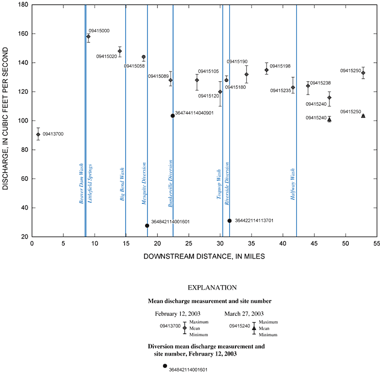
Figure 2. Computed mean, and maximum and minimum discharge measurements for selected sites from the Virgin River Narrows, Arizona, to Lake Mead, Nevada, February 12 and March 27, 2003. See table 1 for site information.
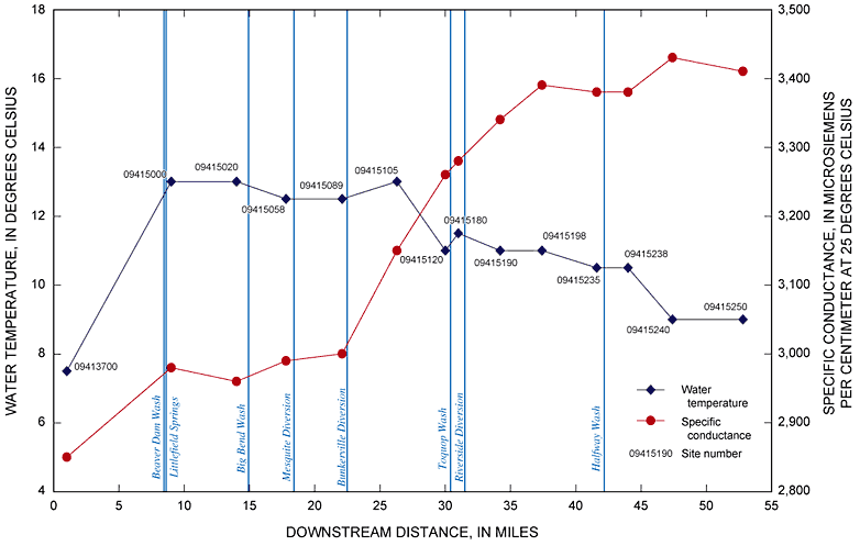
Figure 3. Mean water-temperature and specific-conductance measurements from selected sites from the Virgin River Narrows, Arizona, to Lake Mead, Nevada, February 12, 2003. See table 1 for site information.

![]() U.S. Department of the Interior |
U.S. Geological Survey
U.S. Department of the Interior |
U.S. Geological Survey
Persistent URL: https://pubs.water.usgs.gov/sir20055286
Page Contact Information: Publications Team
Page Last Modified: Thursday, 01-Dec-2016 18:51:31 EST
