Scientific Investigations Report 2006-5019
U.S. GEOLOGICAL SURVEY
Scientific Investigations Report 2006-5019
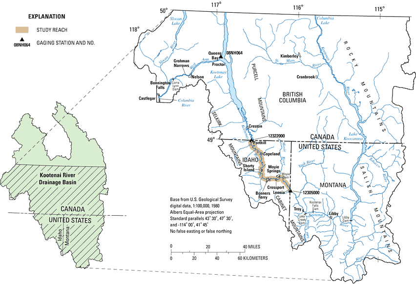
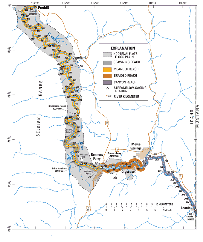
A one-dimensional (1-D) hydraulic-flow model of a 105.6 km reach of the Kootenai River in Idaho was developed by the U.S. Geological Survey (USGS) to aid in evaluating hydraulic characteristics in the reach (Berenbrock, 2005). The primary focus of the model was to determine the location of the transition between backwater and free-flowing water in the Kootenai River because many biologists believe that hydraulic changes at the transition affect the location where sturgeon choose to spawn. The modeled reach starts at Leonia (river kilometer [RKM] 276.5) near the Montana/Idaho border and ends at Porthill (RKM 169.9) near the International Border (fig. 1). The modeled reach also encompasses the white sturgeon spawning habitat reach (RKM 246.7 to RKM 224.9) that has been designated as a critical habitat. The model has proven to be a useful tool to simulate hydraulic changes especially in determining the location of backwater extent.
Concerned with enhancing spawning conditions of the white sturgeon in the Kootenai River, the U.S. Fish and Wildlife (USFWS) is deciding how far to extend the critical habitat reach upstream into the braided and (or) canyon reaches. The braided reach extends from U.S. Highway 95 Bridge (RKM 245.8) at Bonners Ferry to RKM 256.6 (near Crossport). The canyon reach extends from RKM 256.6 to Libby Dam (RKM 354) (fig. 2). The streambed in the braided and canyon reaches is composed primarily of gravel and cobbles and is suitable for white sturgeon spawning. Whereas, the meander reach (downstream of Bonners Ferry) of the Kootenai River is composed primarily of medium to fine sand, which is unsuitable for spawning. In September 2005, the USGS, in cooperation with the USFWS, used the 1-D hydraulic model to aid the USFWS in deciding how best to extend the length of channel designated as the critical habitat reach. These additional simulations are needed to determine if hydraulic characteristics of the braided and canyon reaches are reasonable for white sturgeon spawning.
The purpose of this report is to document simulations that were not included in Berenbrock (2005) and that are needed to determine if hydraulic characteristics of the braided and canyon reaches are reasonable for white sturgeon spawning.
Hydraulic characteristics in the braided and canyon reaches are of primary focus in these simulations. Two tasks comprise these simulations. Task 1 consists of simulating combinations of five river discharges (6, 000; 20,000; 40,000; 60,000; and 75,000 ft3/s) and three water-surface elevations (low, median, and high) in Kootenay Lake. Task 2 consists of simulating nine river discharges (6,000; 10,000; 20,000; 30,000; 40,000; 50,000; 60,000; 70,000; and 75,000 ft3/s) and only the median water-surface elevations in Kootenay Lake. For river discharges of 40,000 ft3/s and less, water-surface elevations in Kootenay Lake were based on data from the Libby Dam era (1973 to 2003). For river discharges greater than 40,000 ft3/s, lake elevations were based on data from the pre-Libby Dam era (1940 to 1972). A complete description of the study reach and the 1-D model that was calibrated is contained in a report by Berenbrock (2005).
River kilometers identified in this report were based on interpolating between the river miles designators that were established by the Columbia Basin Inter-Agency Committee (1965). The river mile designators are usually shown on USGS 7.5-minute (1:24,000 scaled) maps, and they were also shown on maps in previous USGS investigations of the Kootenai River (Barton and others, 2004; Berenbrock, 2005, Berenbrock and Bennett, 2005). Please note that other river kilometers designators that have been established by other agencies and (or) identities such as the Idaho Department of Fish and Game may not agree with the locations of river kilometers used in this report.
For more information about USGS activities in Idaho, visit the USGS Idaho Water Science Center home page .

![]() U.S. Department of the Interior |
U.S. Geological Survey
U.S. Department of the Interior |
U.S. Geological Survey
Persistent URL: https://pubs.water.usgs.gov/sir20065019
Page Contact Information: Publications Team
Page Last Modified: Thursday, 01-Dec-2016 18:54:29 EST
