Scientific Investigations Report 2006-5035
U.S. GEOLOGICAL SURVEY
Scientific Investigations Report 2006-5035
Frequency statistics, such as the 7-day, 10-year low flow [7Q10; annual minimum mean discharge for 7 consecutive days, which has a 0.1 (1/10; 10 percent) probability of not being exceeded in any one year], commonly are used by States when setting effluent limits and allowable pollutant loads to meet water-quality standards. These same low-flow frequency statistics also indicate the probable availability of water in streams during times when conflicts between water supply and demand are most prevalent. Because of this, low-flow statistics are needed by Federal, State, and local agencies for regulatory activities and water-use planning and management. Low-flow statistics also are used by commercial and hydroelectric facilities to determine the availability of water for supply and power generation.
In Idaho, more than 800 river reaches have been designated as impaired [exceeding water-quality and(or) biological criteria]. These reaches have or will have their load of pollutants analyzed and maximum loading rates set by Total Maximum Daily Load (TMDL) assessments. To determine the load of a constituent in a stream, streamflow-quantity information is needed. This information is especially important for low-flow periods when agencies need to determine the maximum effluent limits for National Pollution Discharge Elimination System (NPDES) discharge permits.
The U.S. Geological Survey (USGS) operates a network of streamflow-gaging stations in Idaho that provides streamflow data for a variety of purposes, and low-flow statistics can be calculated from the streamflow data collected at these locations. However, it is not feasible to operate gaging stations at all locations where low-flow statistics are needed. Because of this, methods are needed that can be used to estimate low-flow statistics at locations where no streamflow information exists. This is most often accomplished using regionalization techniques and regression analyses that relate low-flow statistics to selected physical and climatic characteristics of drainage basins.
The last Statewide evaluation of low-flow characteristics by the USGS was published in 1996 and included flow data through 1990 (Kjelstrom and others, 1996). Although this report included low-flow statistics over a wide range of flow durations and recurrence intervals, it only included low-flow statistics at gaged sites with 10 or more years of continuous record. Because methods are needed to estimate low-flow statistics at ungaged sites throughout Idaho, the USGS, in cooperation with the Idaho Department of Environmental Quality (IDEQ), began a study to develop methods for estimating the 1Q10, 7Q2, 7Q10, and 30Q5 low-flow frequency statistics at ungaged sites. In the past, estimating low-flow statistics at ungaged sites has met with only limited success because of difficulties in adequately describing the effects of geology and other factors that typically affect low flows (Riggs, 1972). The use of GIS (Geographic Information System) to obtain a larger number of basin characteristics, especially geologic characteristics, and the improved accuracy of source data may significantly improve the success of this method.
This report presents techniques used to develop regional regression equations that can be used to estimate various low-flow statistics for ungaged sites on unregulated streams in Idaho. Multiple linear regression analyses were used to develop equations for estimating the 1Q10, 7Q2, 7Q10, and 30Q5 low-flow frequency statistics at ungaged, unregulated sites on streams in Idaho, and logistic regression analyses were used to develop equations for estimating the zero-flow probability for 1-, 7-, and 30-day low flows. The report also describes the associated reliability and limitations of the regression equations. Regression statistics, such as the standard error of estimate, were calculated to help assess the reliability and accuracy of each equation.
Relevant low-flow frequency statistics (1Q10, 7Q2, 7Q10, and 30Q5) were updated for the gaging stations in Idaho and adjacent States used in the equation development process. These gaging stations included all those in Idaho, and some in adjacent States, with generally 10 or more years of record on streams unaffected by regulation and(or) diversions. Relevant low-flow statistics updated through water year 2003 for these gaging stations also are presented in this report.
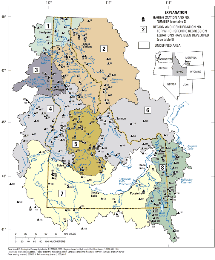
The study area (fig. 1) includes the entire State of Idaho and areas in the adjacent States of Washington, Oregon, Nevada, Utah, Wyoming, and Montana where particular drainage basins cross over State boundaries. The northern and central parts of the area are composed mainly of rugged, mountainous terrain; broad plains and mildly sloping valleys and hills predominate in the south. Geologic features across the study area consist of sedimentary, igneous, and metamorphic rocks ranging in age from Precambrian to Holocene (Bond, 1978). The granitic Idaho batholith is the major structural feature in the central part of the study area, and basalt covers much of the southern and western parts (Ross and Savage, 1967).
Most precipitation in the study area results from storms moving inland from the Pacific Ocean. The amount of precipitation varies widely throughout the area and is greatly affected by topography. Precipitation ranges from less than 10 in/yr on the Snake River Plain in south-central Idaho to 60 to 70 in/yr in the central mountains of Idaho (Molnau, 1995). The most significant amounts of precipitation are a direct result of orographic effects and occur primarily in the winter months. Spring and summer thunderstorms in the southern part of the study area sometimes produce large amounts of localized precipitation. Resulting streamflow varies geographically and seasonally and can be affected by land use and vegetation. During much of the year, typically August through March, streamflow in most unregulated streams in the study area is minimal base flow; during April, May, June, and July, streamflow is significantly greater, primarily as a result of snowmelt. Annual minimum streamflows typically occur during October through January. Occasionally during the winter months, large frontal systems carrying warmer air release moisture as rain on the snowpack and frozen ground, which results in rapid snowmelt and high runoff rates, particularly at altitudes less than 6,000 ft above sea level (National Oceanic and Atmospheric Administration, 1971).
Various low-flow statistics for selected gaging stations in Idaho with 10 or more years of record through 1990 were determined by Kjelstrom and others (1996). The statistics included the annual minimum mean discharges for periods of 1, 3, 5, 7, 14, 30, 60, 90, 120, and 183 consecutive days for recurrence intervals of 2, 5, 10, 20, 50, and 100 years. Kjelstrom and others (1995) also documented annual minimum discharges for selected gaging stations in Idaho with 5 to 9 years of record through 1990.
Although no studies have been completed that document methods for estimating low-flow statistics at ungaged sites in Idaho, several studies resulted in methods for estimating monthly-exceedance, annual-mean, and peak-flow statistics at ungaged sites. Most recently, regional regression techniques were used to develop equations that can be used to estimate various streamflow statistics at ungaged sites. These techniques resulted in equations for estimating the following statistics: monthly-exceedance and annual-mean discharges (Hortness and Berenbrock, 2001); peak-flow discharges (Berenbrock, 2002); and bankfull-flow discharges (Hortness and Berenbrock, 2003).
Quillian and Harenberg (1982) and Horn (1988) developed methods for estimating mean annual discharges in streams across Idaho. Kjelstrom (1998) developed a method for estimating the 20-, 50-, and 80-percent monthly-exceedance discharge values for the Salmon and Clearwater River Basins in central Idaho using the mean monthly discharge and a multiplication factor. This method pertains only to the approximately 1,050 subbasins identified by Lipscomb (1998), who estimated the mean monthly discharges for each subbasin by apportioning mean annual discharges into monthly increments on the basis of records from gaging stations selected as being characteristic of the subbasin. Lipscomb estimated the mean annual discharges by using the regional regression equations developed by Quillian and Harenberg (1982).
Thomas and others (1973), Kjelstrom and Moffatt (1981), and Quillian and Harenberg (1982) developed regional regression equations for estimating peak flows at ungaged sites in Idaho. Portions of Idaho also were included in regional peak-flow studies by Hedman and Osterkamp (1982) and Thomas and others (1994). Regression equations specific to bankfull flows were developed for the Salmon River Basin by Emmett (1975) and for the entire State by Harenberg (1980).
For more information about USGS activities in Idaho, visit the USGS Idaho Water Science Center home page .

![]() U.S. Department of the Interior |
U.S. Geological Survey
U.S. Department of the Interior |
U.S. Geological Survey
Persistent URL: https://pubs.water.usgs.gov/sir20065035
Page Contact Information: Publications Team
Page Last Modified: Thursday, 01-Dec-2016 18:55:00 EST
