 |
|
|
||||
| Scientific Investigations Report 2006-5249 |
Prepared in Cooperation with
Eureka, Lander, and Nye Counties, Nevada
and the State of Nevada Department of Conservation and Natural Resources,
Division of Water Resources
By Mary L. Tumbusch and Russell W. Plume
Download SIR2006-5249 as a PDF: Report (2 Mb) || Plate (16 Mb; 22" x 28")
 |
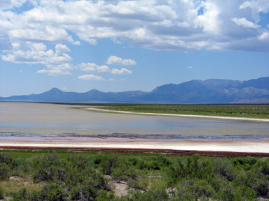 |
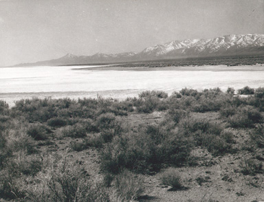
View looking south from the north end of southern Monitor Valley. Left photo: cover of Rush, F.E. and Everett, D.E., 1964,
Ground-water appraisal of Monitor, Antelope, and Kobeh Valleys, Nevada: Nevada Department of Conservation and Natural
Resources, Ground-Water Resources
- Reconnaissance Report 30. Right photo: same view, 2006.
The Diamond Valley flow system, an area of about 3,120 square miles in central Nevada, consists of five hydrographic areas: Monitor, Antelope, Kobeh, and Diamond Valleys and Stevens Basin. Although these five areas are in a remote part of Nevada, local government officials and citizens are concerned that the water resources of the flow system eventually could be further developed for irrigation or mining purposes or potentially for municipal use outside the study area. In order to better understand the flow system, the U.S. Geological Survey in cooperation with Eureka, Lander, and Nye Counties and the Nevada Division of Water Resources, is conducting a multi-phase study of the flow system.
The principal aquifers of the Diamond Valley flow system are in basin-fill deposits that occupy structural basins comprised of carbonate rocks, siliciclastic sedimentary rocks, igneous intrusive rocks, and volcanic rocks. Carbonate rocks also function as aquifers, but their extent and interconnections with basin-fill aquifers are poorly understood. Ground-water flow in southern Monitor Valley is from the valley margins toward the valley axis and then northward to a large area of discharge by evapotranspiration (ET) that is formed south of a group of unnamed hills near the center of the valley. Ground-water flow from northern Monitor Valley, Antelope Valley, and northern and western parts of Kobeh Valley converges to an area of ground-water discharge by ET in central and eastern Kobeh Valley. Prior to irrigation development in the 1960s, ground-water flow in Diamond Valley was from valley margins toward the valley axis and then northward to a large discharge area at the north end of the valley. Stevens Basin is a small upland basin with internal drainage and is not connected with other parts of the flow system.
After 40 years of irrigation pumping, a large area of ground-water decline has developed in southern Diamond Valley around the irrigated area. In this part of Diamond Valley, flow is from valley margins toward the irrigated area. In northern Diamond Valley, flow appears to remain generally northward to the large discharge area. Subsurface flow through mountain ranges has been identified from Garden Valley (outside the study area) through the Sulphur Springs Range to Diamond Valley and from southeastern Antelope Valley through the Fish Creek Range to Little Smoky Valley (outside the study area). In both cases, the flow is probably through carbonate rocks. Ground-water levels in the Diamond Valley flow system have changed during the past 40 years. These changes are the result of pumpage for irrigation, municipal, domestic, and mining uses, mostly in southern Diamond Valley, and annual and longer-term variations in precipitation in undeveloped parts of the study area. A large area of ground-water decline that underlies an area about 10 miles wide and 20 miles long has developed in the basin-fill aquifer of southern Diamond Valley. Water levels beneath the main part of the irrigated area have declined as much as 90 feet. In undeveloped parts of the study area, annual water-level fluctuations generally have been no more than a few feet.
Abstract
Introduction
Background
Purpose and Scope
Approach
Description of Study Area
Well Designations
Acknowledgments
Geologic Setting
Hydrogeologic Units
Carbonate Rocks
Siliciclastic Sedimentary Rocks
Igneous Intrusive Rocks
Volcanic Rocks
Basin-Fill Deposits
Structural Features
Ground Water in Basin-Fill Deposits
Occurrence and Movement
Historical Water-Level Changes
Phase Two
Summary
References Cited
Appendix 1. Selected drillers’ logs for wells in Monitor, Kobeh, and Antelope Valleys, central Nevada
Appendix 2. Selected well and water-level data for Kobeh, Monitor, Antelope, and Diamond Valleys, for period of record
1. Hydrogeologic framework and ground-water levels in basin-fill deposits of the Diamond Valley flow system, central Nevada
1. Map showing locations of hydrographic areas, weather stations, and selected wells in the Diamond Valley flow system, central Nevada
2. Graphs showing annual precipitation at weather stations at Eureka and Austin, Nevada, 1971–2000, and at Diamond Valley, 1979–2000
3. Hydrogeologic map and ground-water levels in Diamond Valley, central Nevada, 1950
4. Map showing locations of wells and water-level declines 1948–2005 in Diamond Valley, central Nevada
5. Graphs showing depth to water at wells in (A, B, C) Diamond Valley, (D, E) Kobeh Valley, (F) Monitor Valley, and (G) Antelope Valley
1. Hydrographic areas of the Diamond Valley flow system, central Nevada
2. Lithology, thickness, extent, and water-bearing characteristics of hydrogeologic units in Monitor, Kobeh, Antelope, and Diamond Valleys and Stevens Basin, central Nevada
3. Hydrogeologic units penetrated by 14 oil exploration wells in Diamond, Kobeh, Antelope, and Monitor Valleys,
central Nevada
4. Summary, from previous studies, of estimated ground-water inflow, ground-water outflow, and ground water
in storage in the upper 100 feet of the aquifer, 1962–68, in Antelope, Diamond, Kobeh, and Monitor Valleys
and Stevens Basin, central Nevada
Send questions or comments about this report to the author, Mary L. Tumbusch
For more information about USGS activities in Nevada, visit the USGS Nevada Water Science Center home page.

![]() U.S. Department of the Interior | U.S. Geological Survey
U.S. Department of the Interior | U.S. Geological Survey
Persistent URL: https://pubs.water.usgs.gov/sir20065249
Page Contact Information: USGS Publishing Network
Page Last Modified: Thursday, 01-Dec-2016 19:23:50 EST