Scientific Investigations Report 2007-5031
Prepared in cooperation with
Suwannee River Water Management District
 |
Select an option: |
|
CONTENTS Abstract Introduction Background Purpose and Scope Description of the Study Area Hydrology of the Study Area Hydrogeologic Framework Ground-Water Flow System Boundaries Lateral Boundaries Upper and Lower Flow-System Boundaries Hydraulic Properties Ground-Water Withdrawals Ground-Water Flow Modeling Model Calibration Water Budget Sensitvity Analysis Model Limitations Summary Selected References |
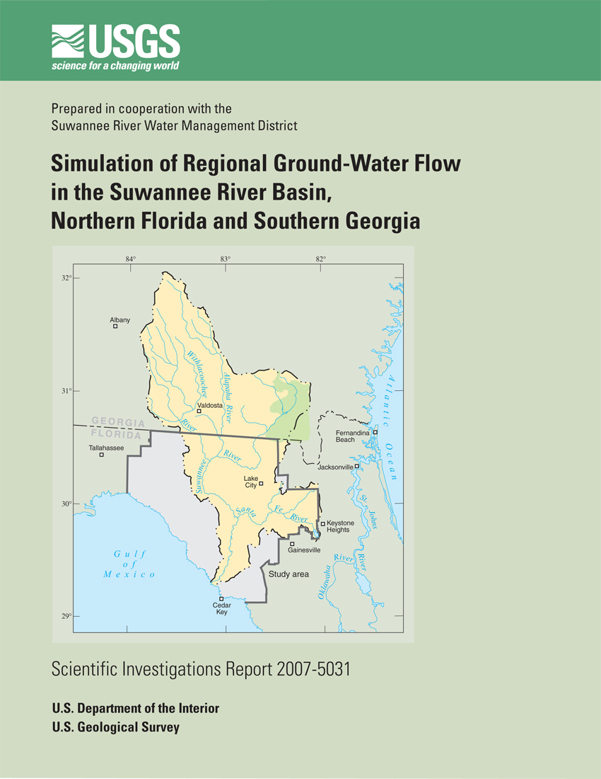
The Suwannee River Basin covers a total of nearly 9,950 square miles in north-central Florida and southern Georgia. In Florida, the Suwannee River Basin accounts for 4,250 square miles of north-central Florida. Evaluating the impacts of increased development in the Suwannee River Basin requires a quantitative understanding of the boundary conditions, hydrogeologic framework and hydraulic properties of the Floridan aquifer system, and the dynamics of water exchanges between the Suwannee River and its tributaries and the Floridan aquifer system.
Major rivers within the Suwannee River Basin are the Suwannee, Santa Fe, Alapaha, and Withlacoochee. Four rivers west of the Suwannee River are the Aucilla, the Econfina, the Fenholloway, and the Steinhatchee; all drain to the Gulf of Mexico. Perhaps the most notable aspect of the surface-water hydrology of the study area is that large areas east of the Suwannee River are devoid of channelized, surface drainage; consequently, most of the drainage occurs through the subsurface.
The ground-water flow system underlying the study area plays a critical role in the overall hydrology of this region of Florida because of the dominance of subsurface drainage, and because ground-water flow sustains the flow of the rivers and springs.
Three principal hydrogeologic units are present in the study area: the surficial aquifer system, the intermediate aquifer system, and the Floridan aquifer system. The surficial aquifer system principally consists of unconsolidated to poorly indurated siliciclastic deposits. The intermediate aquifer system, which contains the intermediate confining unit, lies below the surficial aquifer system (where present), and generally consists of fine-grained, unconsolidated deposits of quartz sand, silt, and clay with interbedded limestone of Miocene age. Regionally, the intermediate aquifer system and intermediate confining unit act as a confining unit that restricts the exchange of water between the overlying surficial and underlying Upper Floridan aquifers. The Upper Floridan aquifer is present throughout the study area and is extremely permeable and typically capable of transmitting large volumes of water. This high permeability largely is due to the widening of fractures and formation of conduits within the aquifer through dissolution of the limestone by infiltrating water. This process has also produced numerous karst features such as springs, sinking streams, and sinkholes.
A model of the Upper Floridan aquifer was created to better understand the ground-water system and to provide resource managers a tool to evaluate ground-water and surface-water interactions in the Suwannee River Basin. The model was developed to simulate a single Upper Floridan aquifer layer. Recharge datasets were developed to represent a net flux of water to the top of the aquifer or the water table during a period when the system was assumed to be under steady-state conditions (September 1990). A potentiometric-surface map representing water levels during September 1990 was prepared for the Suwannee River Water Management District (SRWMD), and the heads from those wells were used for calibration of the model. Additionally, flows at gaging sites for the Suwannee, Alapaha, Withlacoochee, Santa Fe, Fenholloway, Aucilla, Ecofina, and Steinhatchee Rivers were used during the calibration process to compare to model computed flows. Flows at seven first-magnitude springs selected by the SRWMD also were used to calibrate the model.
Calibration criterion for matching potentiometric heads was to attain an absolute residual mean error of 5 percent or less of the head gradient of the system which would be about 5 feet. An absolute residual mean error of 4.79 feet was attained for final calibration. Calibration criterion for matching streamflow was based on the quality of measurements made in the field. All measurements used were rated good, so the desire was for simulated values to be within 10 percent of the field measurements. All river reaches and springs were calibrated to within 5 percent, less than the 10-percent criterion of the measured discharge. Simulated transmissivity values range from 1,000 to 2 million feet squared per day. All relatively high values of transmissivity are associated with springs where the probability of fractures and dissolution have enhanced the primary permeablity of the limestone. The lowest transmissivity values are generally associated with areas of poor drainage where swamps or wetlands are present.
Model-simulated recharge values range from 0.5 inch per year (in/yr) in the confined area of the Upper Floridan aquifer in the northeastern and eastern part of the study area to 20 in/yr near Wacissa Springs. The initial estimate of 7 in/yr proved to be appropriate for most of the unconfined part of the Suwannee River Basin.
Planert, Michael, 2007, Simulation of Regional Ground-Water Flow in the Suwannee River Basin, Northern Florida and Southern Georgia: U.S. Geological Survey Scientific Investigations Report 2007-5031, 50 p.
U.S. Department of the Interior
U.S. Geological Survey
Florida Integrated Science Center
2010 Levy Avenue
Tallahassee, FL 32310
850-942-9500
| Accessibility FOIA Privacy Policies and Notices | U.S. Department of the Interior, U.S. Geological Survey
Persistent URL: https://pubs.usgs.gov/sir/2007/5031/ Page Contact Information: USGS Publishing Network Last modified: Thursday, 01-Dec-2016 19:41:45 EST |
 |