Scientific Investigations Report 2009–5004
Description of Wood River WetlandOrigin of Wood River WetlandThe wetlands surrounding Upper Klamath and Agency Lakes (fig. 1), were formed 10,000–12,000 years ago following recession of an expansive Pleistocene water body filled from melting of glacial ice (Dicken, 1980). This great water body, called Modoc Lake, extended 75 mi from Fort Klamath in southern Oregon, to south of Tule Lake in northern California. Modoc Lake deposited lacustrine clays typically to depths between 2.5 and 12 ft (Snyder and Morace, 1997), but occasionally deeper. Such clays can confine ground-water movement, especially where the layers remain intact. Canal digging and dike building possibly breached some clay layers in wetlands around Upper Klamath Lake, including the Wood River Wetland, altering ground-water flow paths. Atop these clay layers, peat soils developed to varying degrees, storing partly decomposed remnants of annual vegetation and associated nutrients. Under the clay are alternating layers of organic and inorganic sediments that probably were deposited over the 1 million years before the clay layer. Sediment cores from Wocus Marsh near the southwestern part of Upper Klamath Lake (fig. 1) contained peat deposits at about 85 ft depth that may be as old as 400,000 years (Adam and others, 1994). Study Area DescriptionThe Wood River Wetland is bordered by North Canal to the northwest, Sevenmile Canal to the southwest, Wood River to the northeast, and Agency Lake to the south (fig. 2). The property was diked and drained in two stages—the higher, drier, northern parcel in 1948 and the lower, wetter southern parcel in 1957. A central levee maintains the two parcels, a seasonally inundated 1,600-acre North Unit and a more developed wetland, the deeper 1,200-acre South Unit. The Wood River Wetland and the Wood River to the northeast have undergone extensive restoration during the past decade. Restoration included improving water management options, blocking certain canals in the Wood River Wetland to encourage water flow through the historical drainage system, and adding meanders to the Wood River channel (Bureau of Land Management, 2006).
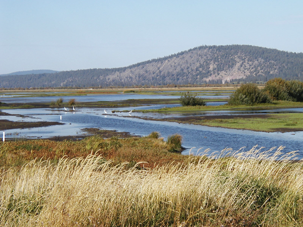
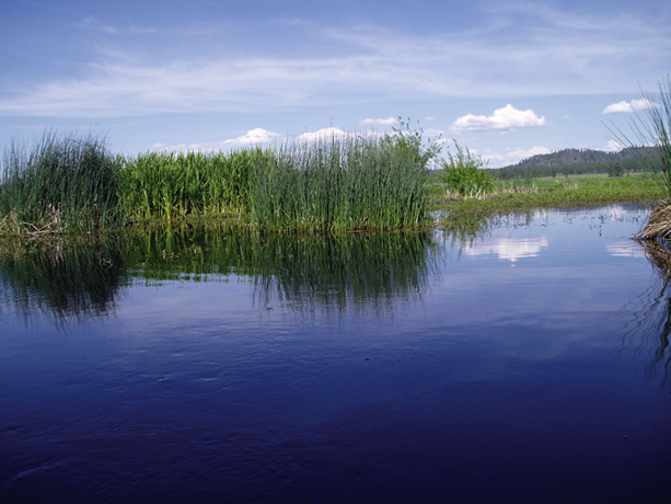
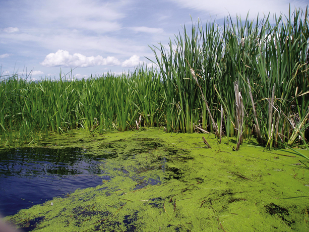
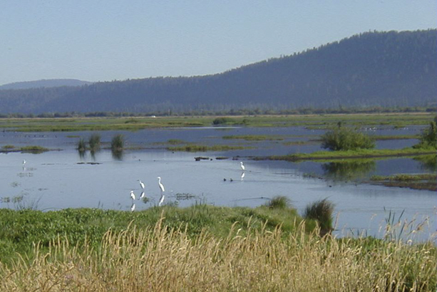
Geology and SoilsUpper Klamath and Agency Lakes are in a large, deep basin filled with layers of volcanic and alluvial sediments, lake clays, and peat soils (Leonard and Harris, 1974). Rocks in the area are predominantly unconsolidated and consolidated volcanic materials (Leonard and Harris, 1974). Large quantities of ash, pumice, and lacustrine deposits of diatoms and peat are hundreds of feet thick (Dicken and Dicken, 1985). Alluvial floodplain deposits consist of volcanic ash-rich clays, silts, sands, along with peat, and other organic materials (Cahoon, 1985; Bureau of Land Management, 1996). Thin horizontal layers of coarse volcanic pumice underlie the Wood River Wetland, which may facilitate lateral water movement along preferential flow paths through the layers. The volcanic pumice was deposited about 7,600 years ago, when a massive eruption from Mount Mazama formed the current Crater Lake (Hallett and others, 1997). Pumice and volcanic ash were deposited or washed down-valley near the Wood River Wetland (Williams, 1965). This and other eruptions during the Holocene epoch produced layers of pumice and ash that underlie the present wetlands in the upper Klamath River basin (Smith, 1988). In the Wood River Valley, south of Crater Lake, a 6-in. thick layer of pumice tapers off to the south (Walker, 1951; Williams, 1965). This layer is visible in the soil cores collected by Snyder and Morace (1997). Three major types of peat soils occur around Upper Klamath Lake: hemic peat, hemic/sapric peat, and sapric peat (Snyder and Morace, 1997). Hemic peat is undecomposed to moderately decomposed peat; hemic/sapric peat is intermediately decomposed peat; sapric peat is the most decomposed. Peat color indicates the degree of decomposition (Cameron, 1973; 1975). Hemic peat, either newly exposed or well protected from air, is generally light yellow or brown. Partially decomposed hemic or hemic/sapric peat is brown to dark brown; well-decomposed sapric peat is black. Wetland soils are of the Lather-Histosols type, formed from organic matter, and characterized as poorly drained mucks (Cahoon, 1985). Climate, topography, and changes in water table depth are the primary drivers in the formation and preservation of peat deposits (Cameron and others, 1989). Draining the Wood River Wetland has resulted in the decomposition of peat soils, which is evident in the various occurrences of sapric peat, land subsidence, and loss of mineral and nutrient content in soil cores (Snyder and Morace, 1997). Vegetation and Other BiotaVegetation in the Wood River Wetland includes willow thickets and obligate wetland species such as cattail (Typha latifolia), giant bur-reed (Sparganium eurycarpum), and spikerush (Eleocharis macrostachya) that also are scattered throughout the mostly flooded South Unit, in shallow areas unaffected by the canals. The plant communities at the wetland were similar to those reported at the Twitchell Island restoration wetlands in the Sacramento-San Joaquin River Delta, California (Miller and others, 2008), and include nearly 150 species (Bureau of Land Management, 2006). The plant community is in a dynamic state of change characterized by a general shift from grazing resistant, edge, and upland plants toward obligate wetland species (Bureau of Land Management, 2006). High nutrient concentrations provide for enhanced growth of numerous species, including submerged macrophytes such as coontail (Ceratophyllum demersum), Canadian waterweed (Elodea canadensis), and curly pondweed (Potomogeton crispus). A variety of filamentous green algae, duckweed, and other plants occur in the open-water areas, canals, and in shallow ponds during summer. Around the wetland fringe, particularly in the South Unit, shallow margin areas teem with aquatic life including diving beetles and zooplankton, which feed a diversity of bird life. Nearly 200 bird species have been identified in the area, with waterfowl counts of 25,000–80,000 during peak use periods in spring and autumn (Bureau of Land Management, 2006).
Climate and Water AvailabilityThe semiarid climate in the upper Klamath River basin is characterized by hot, dry summers and moderately wet winters with moderate to low temperatures. Most precipitation occurs between October and March, producing marked seasonal fluctuations in water levels. During winter, precipitation often is in the form of snow, and ice often forms on the surface of the wetland (Bureau of Land Management, 2006). During high snowpack years, high-quality meltwater infiltrates and recharges the ground-water system while surface runoff pulses down the stream network in the Wood River Valley and is used for flood irrigation of pastures. Subirrigation, the irrigation of plants by water delivered to the roots from shallow ground water, also occurs in the Wood River Valley when ground-water levels are sufficiently high (Graham Matthews and Associates, 2005). Large seasonal temperature changes in the upper Klamath River basin are due to the semiarid climate and high elevation (more than 4,000 ft). Summer months are dry, hot, and often windy. Solar intensity, which is higher at this elevation, adds heat that contributes to high rates of evapotranspiration (ET)—the loss of water from evaporation and plant transpiration. HydrologyThe wetland is isolated from adjacent surface-water bodies and adjoining property by levees, and water control structures are located at key sites throughout the wetland to manage water levels. The inflow of surface water for irrigation is controlled and generally enters the wetland by first passing into North Canal, on the north side of North Dike Road (fig. 2). North Canal is filled with water from Sevenmile Canal during flood irrigation, and from overland and subsurface drainage from the adjoining property upgradient (north) of the wetland. Although water from Wood River can be used, Sevenmile Canal is the primary water source during flood irrigation because the inlet structure includes a fish screen. Water from North Canal is routed into the North Unit through control structures along the North Dike Road, at the north end of the north-south trending canals. Although separate, the two parcels that compose the wetland may be partly hydrologically connected by ground-water transport through the horizontal pumice sand and gravel layers. Minor surface-water movements primarily are in the upland North Unit, from the northwest corner to the southeast, following canals and parts of a former natural channel toward the Wood River pump station (fig. 2). Water accumulated in the southeast corner of the North Unit can be pumped into Wood River or passed into the South Unit through a water control structure near the pump station, and gates can be managed for draining units independently. A second pump station in the southwest corner of the South Unit can be used to discharge water to the lower reaches of Sevenmile Canal. However, during this investigation (2003–05) only a negligible amount of pumping took place from either pump station for pump maintenance. Additional sources of water inflow include direct precipitation, regional ground-water discharge, seepage through the dikes, and discharge from five flowing artesian wells on the wetland. The only significant outflow of water from the wetland during the study period was evaporation from areas of open water and evapotranspiration from plants. Historical and Current Water ManagementFrom 1985 through 1994, the Wood River Wetland was managed for beef cattle production (Bureau of Land Management, 2005). Prior to 1995, water accumulated during winter was pumped off in February or March through May, until surface water was confined to the drainage canals. About 1,300 cow-calf pairs grazed the wetland from about April through November. The pasture was flood irrigated with about 3,000–6,000 acre-ft about once per month during summer. Under this management scenario, open water occurred only from December through April, and grasses, sedges, and weeds provided forage for waterfowl and other wildlife. From 1995 through 2005, water that accumulated during winter was not pumped off, allowing full inundation of the South Unit, and seasonal inundation of the North Unit. As the dry summer season progressed, water levels declined and much of the wetland went dry or moist, especially in the North Unit, but also partially in the South Unit. Flood irrigation was limited to one watering per year in September and October, when about 1,000 acre-ft of water was added from Sevenmile Canal to the North Unit to provide additional habitat for migrating and resident waterfowl. Under this management scenario, an annual cycle of drying and wetting occurred in the North Unit during moderate to dry years, while relatively deep water (4–6 ft) persisted in the South Unit canals during spring and early summer. Water depth in the non-canal areas of the South Unit ranged from a few inches to more than 6 ft. The seasonal extent of water inundation is shown in figure 3. Both wetland units combined hold about 16,700 acre-ft of water at a water-surface elevation of 4,142 ft (National Geodetic Vertical Datum of 1929 [NGVD29]). The largest rate of increase in the inundated area occurs between water-surface elevations of 4,135 and 4,138 ft (fig. 4). |
For additional information contact: Part or all of this report is presented in Portable Document Format (PDF); the latest version of Adobe Reader or similar software is required to view it. Download the latest version of Adobe Reader, free of charge. |

![]() U.S. Department of the Interior | U.S. Geological Survey
U.S. Department of the Interior | U.S. Geological Survey
URL: http://
pubsdata.usgs.gov
/pubs/sir/2009/5004/section3.html
Page Contact Information: Contact USGS
Page Last Modified:
Thursday, 10-Jan-2013 19:29:18 EST