WRIR
00-4001
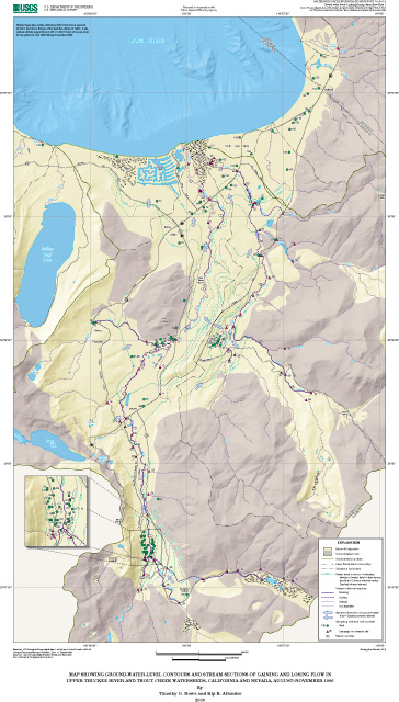
Surface- and Ground Water Characteristics in the Upper Truckee River and Trout
Creek Watersheds
The study area is in the southern part of the Lake Tahoe Basin Hydrographic Area1 and includes the entire Upper Truckee River and Trout Creek watersheds (figs. 1 and 2) in California. Additionally, samples were taken from wells and a spring adjacent to the study area in California and Nevada.
Historically, Trout Creek was tributary to Upper Truckee River in the Truckee Marsh area near the lake (fig. 2). But with development of the Tahoe Keys, the Upper Truckee River was channeled to the lake and currently the streamflow of the two tributaries combine only during high runoff. Because of this historical combination of the Upper Truckee River and Trout Creek on the surface, speculation is that their ground-water systems also may combine at some point. This is one reason that both watersheds are included in this study.
The main geologic units identified within the study area are granitic rocks and glacial deposits. Other units that are much less extensive are pluvial and alluvial deposits, volcanic rock, and metamorphic rock (Tahoe Regional Planning Agency and U.S. Forest Service, 1971, plate).
The geology of the study area can be characterized by lake and glacial deposits at the lower altitudes, flatlands, and low-lying hills; and by granitic rocks that make up the steep and high mountain slopes and peaks. The only volcanic rocks within the study area are in the extreme headwaters of the Upper Truckee River watershed, and the only metamorphic rocks are two small areas above Echo Lake and two small areas in the low-lying hill between the City of South Lake Tahoe and Fallen Leaf Lake. Lake deposits are evident in a few high-mountain meadows and along the lower stream channels in the Upper Truckee River and Trout Creek watersheds (Tahoe Regional Planning Agency and U.S. Forest Service, 1971, plate).
Landforms of the study area were principally shaped from tectonic and glacial processes. A combination of basin-and-range style fault-bounded blocks and glacial erosional and depositional action resulted in the formation of the present-day landforms. Four periods of major glaciation shaped these landforms (Tahoe Regional Planning Agency and U.S. Forest Service, 1971). The major landforms attributed to glaciation are deep basin-fill deposits, steep mountain slopes adjacent to the upper reaches of the Upper Truckee River and Trout Creek, and large lateral moraines that divide the Trout Creek watershed from the Upper Truckee River watershed and the Upper Truckee River watershed from Fallen Leaf Lake (Tahoe Regional Planning Agency and U.S. Forest Service, 1971).
The basin-fill deposits within the study area are comprised entirely of lake, stream, and glacial deposits. Also, the underlying basement rock is assumed to be entirely granitic. Thicknesses of the basin-fill deposits in the South Lake Tahoe area near Lake Tahoe may be as great as 1,600 - 1,900 ft (Blum, 1979). For the purposes of this report, the areas with basin-fill deposits will be referred to as unconsolidated areas and the areas that have exposed bedrock will be referred to as consolidated areas.
Vegetation in the Upper Truckee River and Trout Creek watersheds is primarily coniferous forest with lodgepole pine, ponderosa pine, Jeffrey pine, white fir, red fir, western white pine, mountain hemlock, and sugar pine. Alders, aspen, and willows are common along the stream zones (Cartier and others, 1993).
In the Upper Truckee River watershed, precipitation (mostly in the form of snow) ranges from nearly 25 in. to greater than 60 in., with a general decrease from west to east (Twiss and others, 1971). In the Trout Creek watershed, precipitation ranges from nearly 20 in. to about 40 in. with a general decrease from southwest to northeast. The National Weather Service reported above average annual precipitation during 1996 at the long-term weather stations in Tahoe City and Glenbrook. The daily precipitation record for a nearby National Resource Conservation Service (NRCS) Snow Telemetry (SNOTEL) site near Lake Tahoe just north of Fallen Leaf Lake is shown in figure 7. Most of the precipitation for 1996 (approximately 94 percent) occurred between late November 1995 and mid-May 1996. Minor rainfall amounts were recorded at the end of June, mid-July, and mid-August of 1996. Summer thunderstorms, typical of the study area, were almost absent in 1996.
Historically, the land use of the Lake Tahoe Basin by humans first began with the Washoe Indian Tribe. Major changes in land use occurred with the discovery of the Comstock Lode in nearby Virginia City, Nev. Many trees in the Lake Tahoe Basin, including those within the study area, were harvested to provide shoring timbers for the Comstock mines (Crippen and Pavelka, 1972). When the Comstock era began to decline during the late 1800's, the Lake Tahoe Basin began to emerge as a seasonal vacation area. By the end of World War II, the Lake Tahoe Basin had become an established year-round destination.
The Upper Truckee River watershed is almost entirely within El Dorado County, Calif. (fig. 2). About 3 mi2 of the southern tip is in Alpine County, Calif. This watershed is the largest in the Lake Tahoe Basin and occupies 56.5 mi2, which is 18 percent of the total land area tributary to Lake Tahoe (314 mi2). Upper Truckee River has a drainage perimeter of 53.9 mi (Cartier and others, 1995). The Upper Truckee River main channel length is 21.4 mi. The land-surface altitudes range from lake level to 10,063 ft above sea level at Red Lake Peak (fig. 2).
The lowest land-surface altitude within the study area that is above water is determined by the surface of Lake Tahoe, which can fluctuate from a little below its natural rim of 6,221.9 ft (6,223.0 ft Bureau of Reclamation (BOR) datum) to slightly greater than its legal maximum altitude of 6,228.0 ft (6,229.1 ft BOR datum). For the period of this study, July through December, Lake Tahoe had a maximum lake-surface altitude in July of 6,227.9 ft, a minimum in November of 6,226.1 ft, and a mean of 6,227.0 ft (Bonner and others, 1998).
Percent slope, which describes the steepness of the topography within the watershed, ranges from approximately zero near Lake Tahoe and along the valley bottoms, to as much as 50 in the upper altitudes of the watershed (Cartier and others, 1993). Dominant aspect, which is the compass direction of a slope face, is generally east, west, southwest, and northwest facing slopes.
The main tributary drainages to the Upper Truckee River (pl. 1) include Grass Lake Creek (drainage area of 6.4 mi2; table 2), Angora Creek (5.7 mi2), Echo Creek (5.4 mi2), and Big Meadow Creek (5.1 mi2). Major wetlands include Grass Lake, Osgood Swamp, Truckee Marsh, Benwood Meadow, and Big Meadow (pl. 1). Major lakes include Upper and Lower Echo Lakes and smaller lakes include Dardanelles, Round, Showers, Elbert, Tamarack, Ralston, and Angora Lakes (fig. 2). The only diversion from this watershed is to the American River Basin from Echo Lake, which has a storage capacity of 1,890 acre-ft (Bostic and others, 1997, p. 260).
The Trout Creek watershed is within El Dorado County, Calif., east of the Upper Truckee River watershed (fig. 2). The watershed is the second largest in the Lake Tahoe Basin and occupies 41.2 mi2, which is 13 percent of the total land area tributary to Lake Tahoe. Trout Creek has a drainage perimeter of 34.8 mi. Trout Creek has a main channel length of 12.1 mi. The land-surface altitudes range from lake level to 10,881 ft at Freel Peak (fig. 2).
Percent slope ranges from approximately zero in the lower reach near Lake Tahoe, to 50 at higher altitudes (Cartier and others, 1993). Aspect is a mixture of generally west, east, north, northwest, and southwest facing slopes.
The main tributaries to Trout Creek include Cold Creek (drainage area of 12.8 mi2), Saxon Creek (8.2 mi2), Heavenly Valley Creek (3.0 mi2), and Hidden Valley Creek (1.7 mi2; table 2, pl. 1). Major wetland areas include Truckee Marsh, High Meadows, and Hell Hole (pl. 1, fig. 2). The only lake in the Trout Creek watershed is Star Lake (fig. 2). The major basin diversion is ground-water withdrawal for municipal use.
1 Formal hydrographic areas in Nevada were delineated systematically by the U.S. Geological Survey and Nevada Division of Water Resources in the late 1960's (Rush, 1968; Cardinalli and others, 1968) for scientific and administrative purposes. The official hydrographic-area names, numbers, and geographic boundaries continue to be used in Geological Survey scientific reports and Division of Water Resources administrative activities.
Table
of Contents || Next Section: Inventory and
Measurement Methods
USGS Water home page || USGS
home page
The pathname for this page is <description.htm>
These pages are maintained by S.C. DeMeo <email: scdemeo@usgs.gov>
Last modified: Wednesday, April 12, 2000