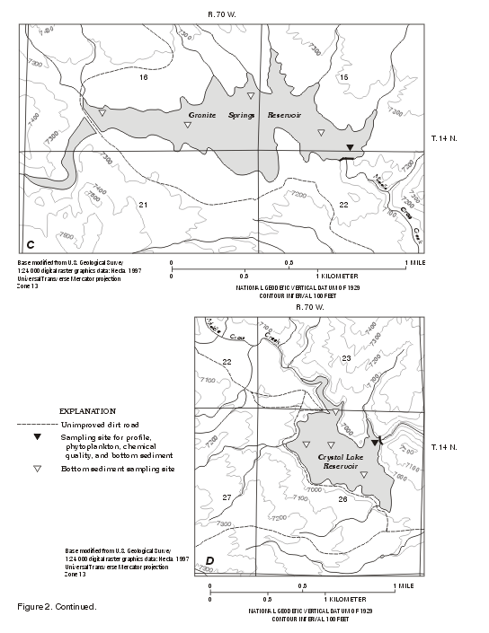
Granite Springs Reservoir is the third reservoir in the series (fig. 2C) and receives water through both Stage I and Stage II pipelines from Lake Owen. The reservoir contains about 12 percent of the system storage and has a spillway elevation of 7,210 ft above sea level (table 1). Granite Springs is located in an area of mixed forest and grassland. It is an active recreational site with boating, fishing, and camping being the primary activities. Some houses are present in the area surrounding the reservoir.
Profile data were collected for Granite Springs once during summer 1997, from mid-May through the first part of October in 1998, and once during winter 1998. These profiles indicate that Granite Springs was stratified by early to mid-July and was unstratified in the winter.
The August 28, 1997 profiles (fig. 16A) indicate stratification in the reservoir. Changes in the temperature, dissolved oxygen, specific conductance, and pH profiles indicate that the epilimnion extended from the surface to about 19 ft deep. In the epilimnion, the temperature decreased from 20 to 18°C, dissolved-oxygen concentrations were about 7 to 8 mg/L, specific conductance was about 94 to 95 µS/cm, and pH ranged from 8.3 to 8.5. Dissolved-oxygen concentrations in the epilimnion were above saturation, probably due to photosynthetic activity by the phytoplankton. The euphotic zone also extended to about 19 ft, as estimated from a Secchi disk transparency of 6.2 ft. The metalimnion appeared to range from about 19 to 26 ft below the reservoir surface. Water temperature, dissolved oxygen, and pH decreased relatively in the metalimnion, while specific conductance increased slightly. In the hypolimnion, dissolved-oxygen concentrations continued to decrease, and were less than the 5 mg/L level suggested for protection of cold-water fish. The dissolved-oxygen concentrations decreased from 73 percent of saturation at 26 ft to 38 percent of saturation at 60 ft.
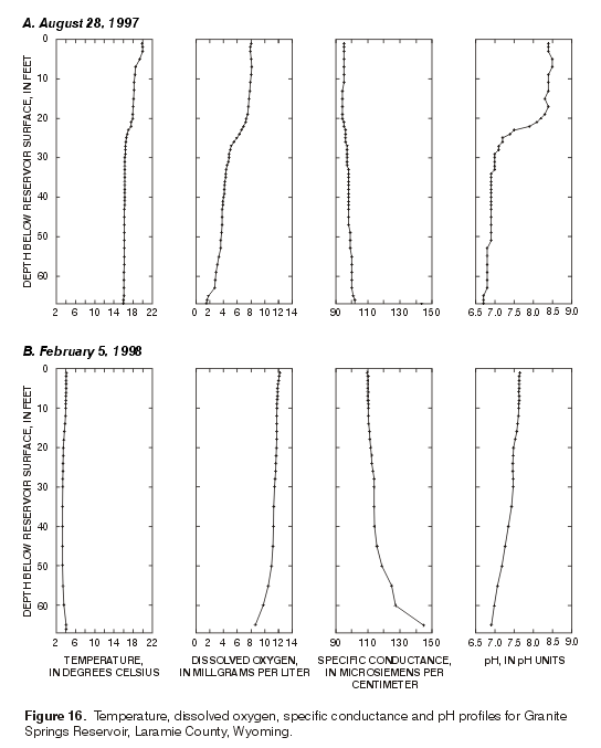
Figure 16. Temperature, dissolved oxygen, specific conductance, and
pH profiles for Granite Springs Reservoir, Laramie County, Wyoming. |
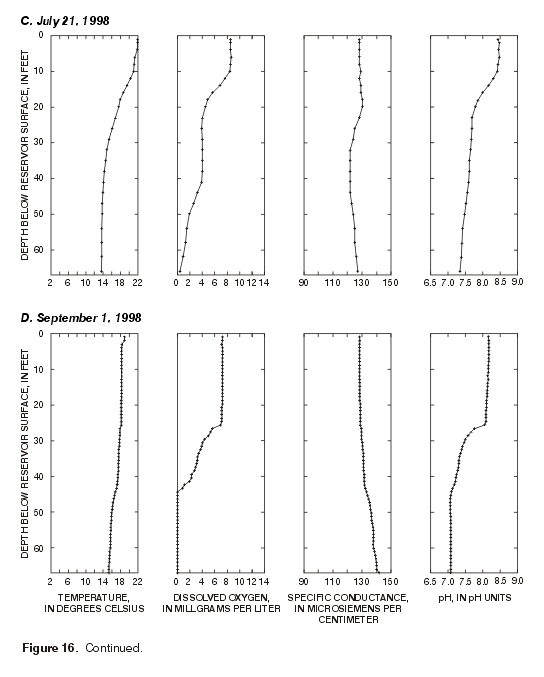
Figure 16. Continued. |
The February 5, 1998 profiles of Granite Springs (fig. 16B) show a lack of stratification in the water column, with only slight changes in the profiles, mostly below about 50 ft. Water temperature was approximately 4°C. Dissolved-oxygen concentrations decreased from about 11 to about 8 mg/L. Specific conductance generally was less than 115 µS/cm to about 50 ft, below which conductance increased to almost 145 µS/cm. pH decreased from 7.7 to 6.9.
July 21, 1998 profiles again show stratification in Granite Springs (fig.16C). The temperature in the epilimnion was about 22°C, dissolved-oxygen concentrations were about 8.5 mg/L, the specific conductance was about 128 µS/cm, and pH measured about 8.5. Changes in temperature and pH occurred in the metalimnion. Below 30 ft, in the hypolimnion, the temperature decreased from about 15 to about 14°C. Dissolved-oxygen concentrations remained near 4.0 mg/L to about 38 ft, then decreased to less than 1 mg/L near the bottom. Specific conductance was about 122 µS/cm from about 32 ft to about 44 ft, then increased to 127 µS/cm. The pH gradually decreased from 7.7 to 7.4.
The September 1, 1998 profiles (fig. 16D) continue to show strong stratification of dissolved oxygen and pH; both were stable to about 25 ft. The metalimnion also was defined by changes in dissolved oxygen and pH. Dissolved-oxygen concentrations dropped from 7.1 to less than 1 mg/L at 45 ft. Over the same interval, pH decreased from 8.1 to 7.1. Temperature decreased gradually from top to bottom in this profile. In the metalimnion and hypolimnion, specific conductance gradually increased.
| Examination of the 1998, Granite Springs temperature profiles (fig. 17) shows a seasonal increase of the water temperature in the reservoir. The reservoir lacked stratification in early May and was a fairly consistent 9°C. By late May into mid June, a nearly linear gradation in temperature developed from about 14°C at the surface to slightly greater than 10°C near the bottom. During this time period, no stratification was present. By July, stratification began to develop in the reservoir (Appendix A). Stratification continued to develop in early August, with the epilimnion expanding down to about 25 ft, and the metalimnion ranged from about 25 to 35 ft. Stratification became less pronounced in mid-August, with the temperature decreasing gradually from about 20 to 14°C with depth. By mid-September, thermostratification had ceased and the profiles indicate little change in water temperature from the reservoir surface to the bottom. In late September and early October, the reservoir cooled quickly compared to its rate of warming (fig. 17). It is interesting to note the persistence of stratification of dissolved oxygen and pH well after temperatures had nearly equalized throughout the water column. | 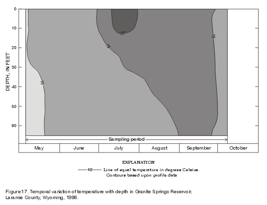
Figure 17. Temporal variation of temperature with depth in
Granite Springs Reservoir, Laramie County, Wyoming, 1998. |
Diatoms and blue-green algae dominated the phytoplankton community of Granite Springs. Although five other divisions of algae were present in the samples, their biomasses were small relative to the diatoms and blue-green algae (fig. 18).
| Blue-green algae, principally Anabaena, dominated the biomass of the algae in the August 28, 1997 and July, 16, 1998 samples. The biomass of Anabaena was 59,000 µg/L (69,100 cells/mL density) in the July 14 sample (Appendix B, table B3). Blue green algae, particularly Anabaena , are known for producing algal blooms and creating taste and odor problems in temperate-zone lakes. The blooms tend to occur in late summer, when water temperatures are warmest and nutrients have been removed from the epilimnion. Many blue-green algae are capable of fixing atmospheric nitrogen, and therefore have a competitive advantage over other algae when nutrient supplies are limited. Somewhat in contrast to this general pattern for temperate-zone lakes, the blue-green algae in Granite Springs peaked in mid-July; diatoms dominated the phytoplankton later in the summer (fig. 18). Peak concentrations of the diatoms were considerably smaller, however, than the peak concentrations of the blue-green algae. | 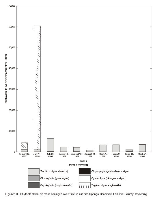
Figure 18. Phytoplankton biomass changes over time in Granite
Springs Reservoir, Laramie County, Wyoming, 1998. |
Both orders of diatoms, the Pennales and the Centrales, were represented in the samples. The pennate diatoms typically are elongate; cigar or boat shaped organisms, whereas the centric diatoms are round, pillbox-shaped organisms (Prescott, 1978, p. 241). The pennate diatom Fragilaria dominated the July 22 and September 1, 1998 samples and was a subdominant species in some of the other samples from Granite Springs. The peak concentration of Fragilaria was 4,200 µg/L (fig. 18) (3,030 cells/mL) in the July 22 sample. The centric diatom Cyclotella was a subdominant in the July 22 sample (1,700 µg/L) and the September 1 sample (1,100 µg/L). The centric diatom Stephanodiscus dominated the August 4 sample and was a subdominant in the September 9 sample, but was not identified in other samples from Granite Springs. An unidentified centric diatom dominated the samples from August 10 and 18, and September 15 and 21. Of the 41 taxa identified from Granite Springs, 15 taxa were diatoms and 13 taxa were green algae.
A phytoplankton sample, collected on August 28, 1997, at 3 ft above the reservoir bottom at the same site as the near-surface sample, contained mostly diatoms. The biomass of the deep sample was 950 µg/L, considerably less than the 4,400 µg/L of the near-surface sample. The cause for the predominance of the diatoms Fragilaria and Melosira in the bottom sample may be related to the resistance of their siliceous shells. The relatively soft-bodied blue-green algae that predominated in the near-surface sample on the same date may have decomposed as they sank through the water column.
Secchi disk transparencies from Granite Springs averaged 8.2 ft. A maximum transparency of 12.5 ft was recorded under ice cover in February; a minimum transparency of 5.1 ft was recorded July 14 and August 4, 1998. The low transparencies on July 14 were coincident with the high phytoplankton concentration. In contrast, the phytoplankton concentration on August 4 was relatively low (fig. 18). Inorganic material suspended in the water may have contributed to the low reading on August 4. The depth of the euphotic zone extended below the thermocline when the reservoir was stratified, indicating adequate light for photosynthesis throughout the epilimnion.
Protozoans were present in samples at concentrations of a few hundred micrograms per liter or less, with the exception of the July 14 sample. The concentration of rotifers in the July 14 sample was 5,000 µg/L biomass (10 organisms/mL).
In Granite Springs in the fall of 1997, MPA was dominated by non-diatomaceous phytoplankton and diatoms. A few rotifers were detected. The MPA results are summarized in table 5.
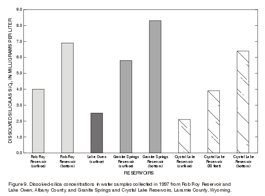
Two samples were collected at Granite Springs (surface and bottom). The dissolved-solids concentrations of 55 mg/L for the surface sample and 59 mg/L for the bottom sample (table 2) indicated little difference in the dissolved solids between the two samples. The water was a calcium bicarbonate type. The relative concentrations of major ions shown in pie diagrams in figure 8 indicate no differences between surface and bottom samples. Dissolved-fluoride concentrations were at 0.3 mg/L in the surface sample and 0.4 mg/L in the bottom sample (table 2). Silica concentrations, as dissolved SiO2, increased slightly with depth (table 2; fig. 9). Nutrient concentrations were less than the detection level in both samples. An exception was dissolved nitrogen as ammonia in the surface sample, which was 0.15 mg/L.
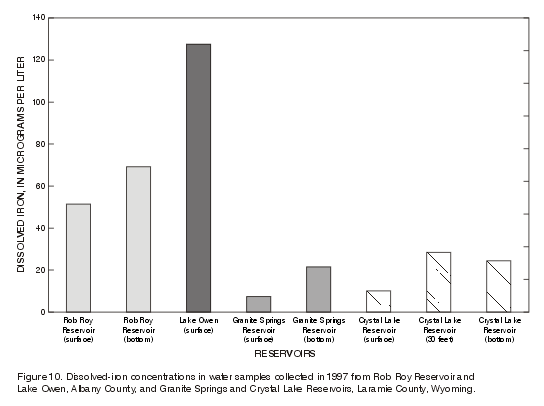
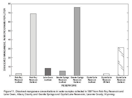
The concentrations of metals indicated some differences between the surface and bottom samples. Iron concentrations increased from 7 µg/L (surface sample) to 21 µg/L (bottom sample) (fig. 10). The increase in manganese concentration from 5 µg/L (surface sample) to 76 µg/L (bottom sample) was even greater (fig. 11).
On February 5, 1998, bottom sediment samples were collected at five sites (fig. 2C) in Granite Springs and composited into a single sample. The composite sample was analyzed for selected constituents (table 3). Nitrogen concentration, reported as total nitrate plus nitrite, was less than the detection limit. Of the constituents analyzed, aluminum concentration was 6.2 percent, iron was 2.2 percent, and potassium was 3.3 percent.
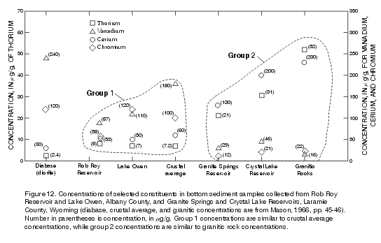
Most bottom-sediment concentrations were in the microgram-per-gram range. Concentrations of nitrogen, arsenic, bismuth, cadmium, europium, gold, holmium, molybdenum, silver, sulfur, tantalum, tin, and uranium were less than the detection limit (table 3). Concentrations of thorium, vanadium, cerium, and chromium are plotted in figure 12. The trace-element concentrations fit best in Group 2--more like granitic rocks than either diabase or the crustal average. The similarity is most likely due to the sediments having been derived from the surrounding Sherman Granite (Precambrian).
[Table of Contents] [Abstract]
[Introduction]
[Rob Roy Reservoir]
[Lake Owen]
[Granite Springs
Reservoir] [Crystal Lake Reservoir]
[Summary]
[Appendix A]
[Appendix B]