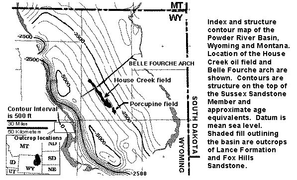
Figure 1. Structure contour map on the top of the Upper Cretaceous Sussex Sandstone Member of the Cody Shale, and approximate age equivalents, Powder River Basin, Wyoming and Montana. Location of the House Creek field is shown. Areal extent of the Sussex "B" sandstones is delineated by black-colored fields. Shaded fill outlining the basin are outcrops of Lance Formation and Fox Hills Sandstone. The rectangle located next to the 30-miles scale bar defines the area of studied outcrops of the Sussex and Shannon Members, much of the Salt Creek anticline, and the towns of Midwest and Edgerton. Contour interval is 500 ft. Datum is mean sea level. A detailed (176 KB) version is named indexfig.gif.
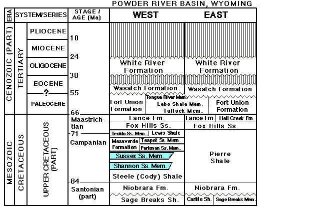
Figure 2. Stratigraphic nomenclature for Upper Cretaceous and Tertiary rocks, Powder River Basin (stratprb.gif, 32 KB).
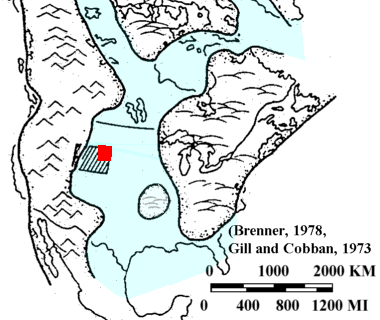
Figure 3. Map showing Cretaceous epicontinental seaway paleogeography during Campanian time (Late Cretaceous) (modified from Brenner, 1978, reprinted by permission, Gill and Cobban, 1973) (wseaways.gif). The large rectangle is Wyoming, the small one shows location of the Powder River Basin.
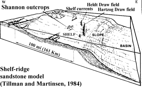
Figure 4. Basin morphology during deposition of shelf sandstone beds in the Powder River Basin (Tillman and Martinsen, 1984 reprinted by permission). The House Creek field is located about 10 miles (16 km) east of and approximately parallel to Hartzog Draw field. Oil in the Hartzog Draw and Heldt Draw fields is produced from the Upper Cretaceous Shannon Sandstone.
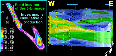
Figure 5. This north-south-oriented vertical slice of the 3-D porosity model (3dns_img.htm) shows upward and westward (landward) increase in sediment thickness, and progressive westward deposition of later sands in the Sussex "B" sandstone (wedgessx.gif). Blue on the 3-D model is primarily mudstone and sandstones containing less than 8 percent porosity, green is mainly fine- to medium-grained sandstones exhibiting 8 to 12 percent porosity, and yellow contours are mainly medium-grained trough-cross-bedded sandstones that contain greater than 12 percent porosity. Respective average porosity of the "B" sandstone and of reservoir intervals are about 8 percent and 12 percent. Slice width and thickness are about 2.5 mi (4 km) and 50 ft (15 m). Vertical exaggeration is 60x. Yellow dots are well sample locations. Index contour map shows cumulative oil production per well; contour interval is 40,000 barrels.
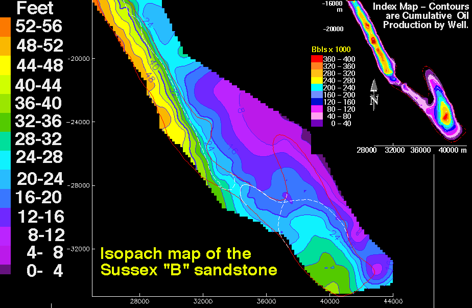
Figure 6. Isopach map of the Sussex "B" sandstone showing thickness in feet of the interval between bounding disconformities; contour interval is 4 ft (1.2 m). Map scales are meters. The small index contour map is cumulative oil production; contour interval is 40,000 barrels. The thin red line outlines the boundary of the House Creek field. Thin white lines in the southern half of the field are limits of sand ridge 1 and overlying sand ridge 2. The large-scale 64 KB image is named ssxiso.gif .
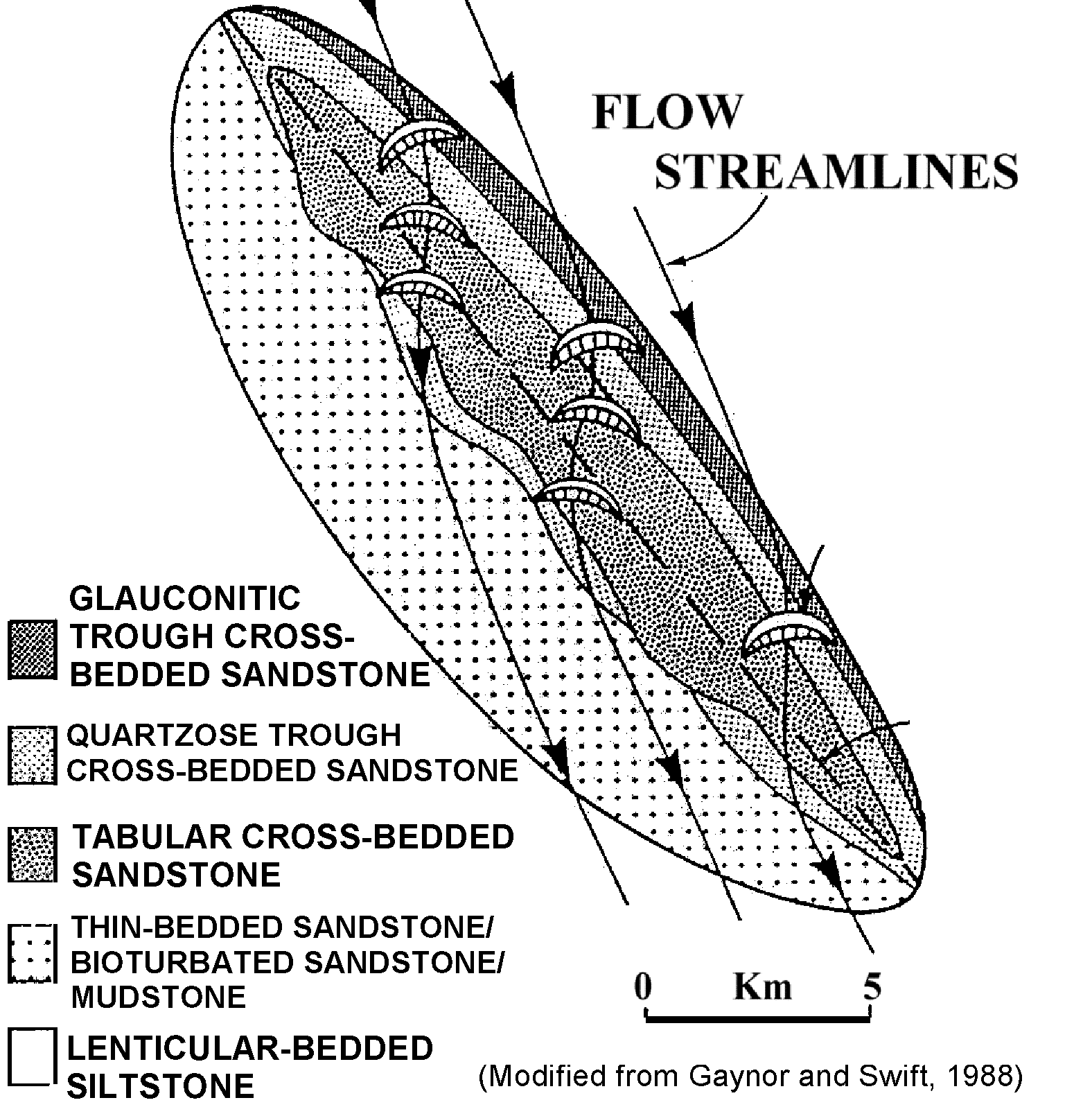
Figure 7. Plan view of lithofacies distribution on a sand ridge, and generalized flow streamlines (srplanvs.gif). Flow streamline arrows are the directions of currents over the sand ridge. Scale is approximate. Click sand Ridge - plan view (Gaynor and Swift, 1988, reprinted by permission) to see the detailed (srplanvw.gif) image (208 KB).
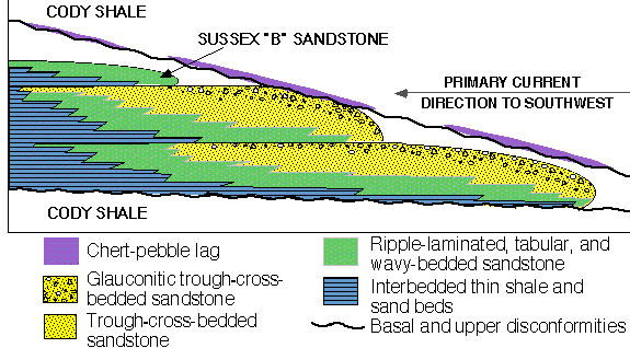
Figure 8. Idealized east-west-oriented vertical section across three stacked sand ridges (ssxflowu.gif). General facies types are listed. No vertical or horizontal scales.
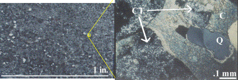
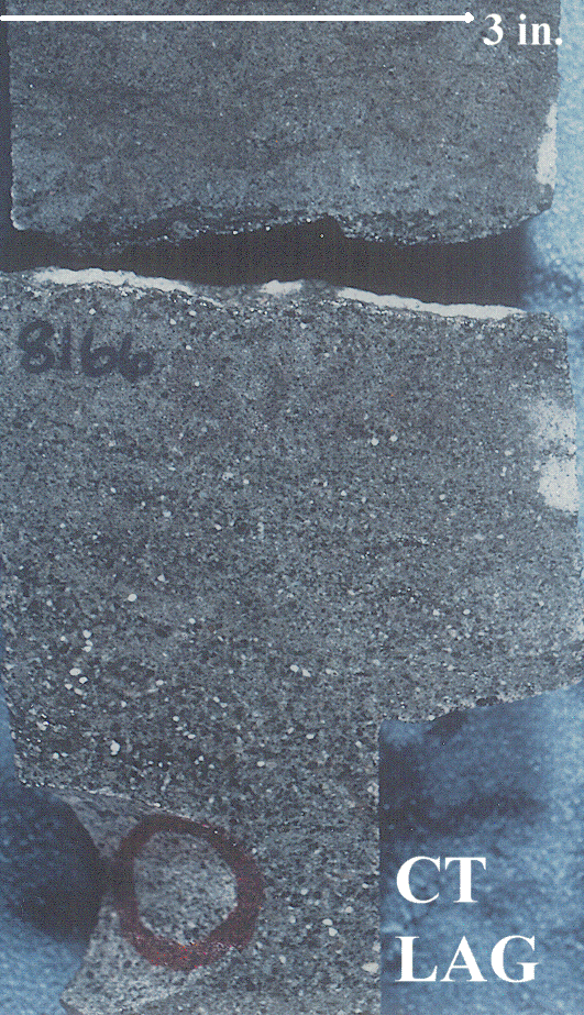
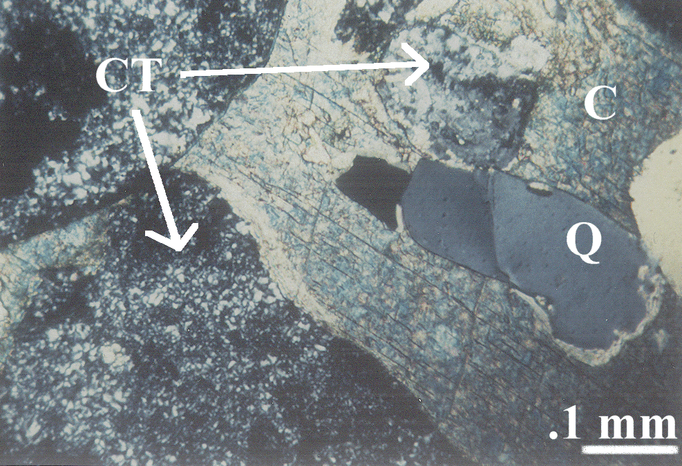
Figure 9. A. Chert-pebble-lag core photograph, and B. crossed-nicols photomicrograph of a chert-pebble lag, No. 14-9 Federal well. Chert pebble lag core links the detailed (576 KB) ctlagc.gif core image. The bimodal grain distribution (mix of large and small grains) is visible on both images. Chert pebble thin section shows the large-scale (736 KB) ctlagts.gif photomicrograph image. Labels are Q quartz, CT chert, and C calcite. Quartz grains incorporated from underlying central-ridge facies sandstones commonly "float" in a matrix of (blue stained) ferroan carbonate cement.
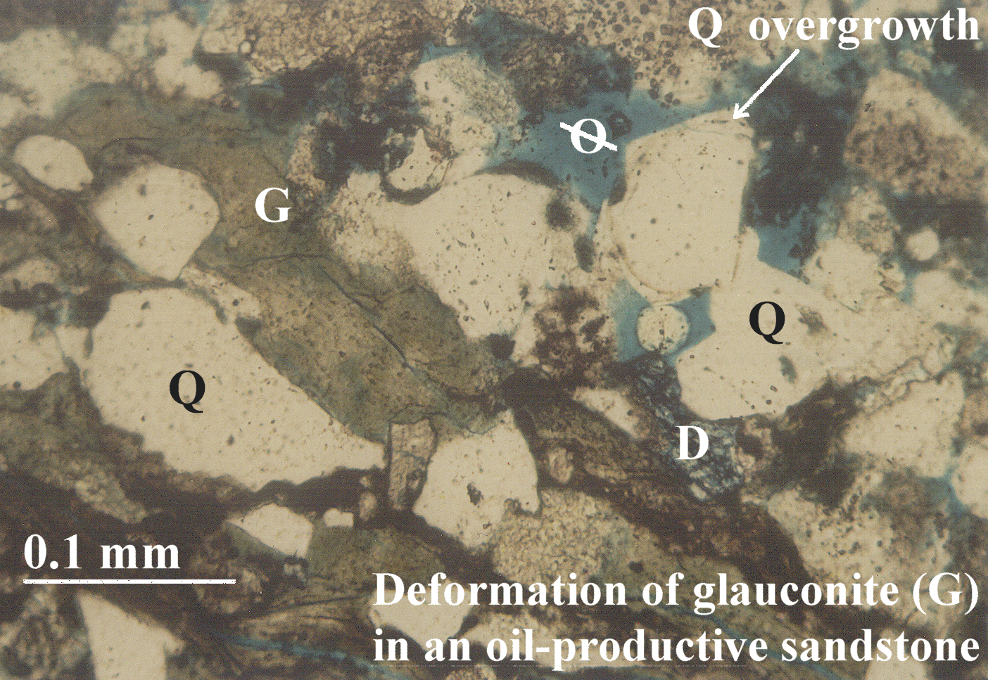
Figure 10. This transmitted-light thin-section image is from 8,014 ft (2,443 m) depth in the Empire-Federal "C" oil well. Deformation of glauconite (G) pellets and other soft sediments in trough-cross-bedded sandstones form microscopic and macroscopic permeability baffles to fluid flow. Note also that quartz (Q) grains surrounded by glauconite do not exhibit the later-diagenetic quartz cementation. Mudstone (brown) and glauconite (green) are concentrated along the lower-depositional-energy laminae of trough-cross-bedded sandstones. Late-diagenetic dolomite cement is stained dark blue (D). Medium-blue epoxy fills pore spaces (ellipse with a line through it). Glauconite is 1.4 MB thin section (glauts.gif) image.

Figure 11. Photograph of an outcrop of Sussex Sandstone Member low-energy-ridge-margin (LRM) sandstone; outcrop is located in NW. corner of sec. 7, T. 40 N., R. 78 W., Natrona Co., Wyoming. LRM thickness is about 1 ft (0.5 m). Greater dispersal of glauconite, clays, and mud in lower depositional energy facies decreases porosity and permeability. This thin trough-cross-bedded sandstone, and the bounding burrowed and bioturbated sandstone/mudstone facies, contain mudstone and glauconite laminae and beds that are preferentially eroded, causing greater relief. Blue and purple lines in this small-scale image separate bedding planes. Trough cross-bedded sandstone 1 MB (ssxcrp2.gif) outcrop image.
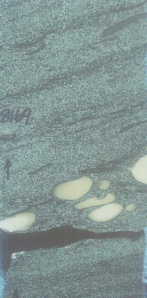
Figure 12. Core photograph of trough-cross-bedded medium-grained sandstone from 8,169-ft depth in the No. 1 Mandel-Federal well. Depths are in feet. Arrow points up. Siderite (S) clasts are concentrated on the bedding planes. Trough cross-bedded sandstone 512 KB (trs8169.gif) core image.
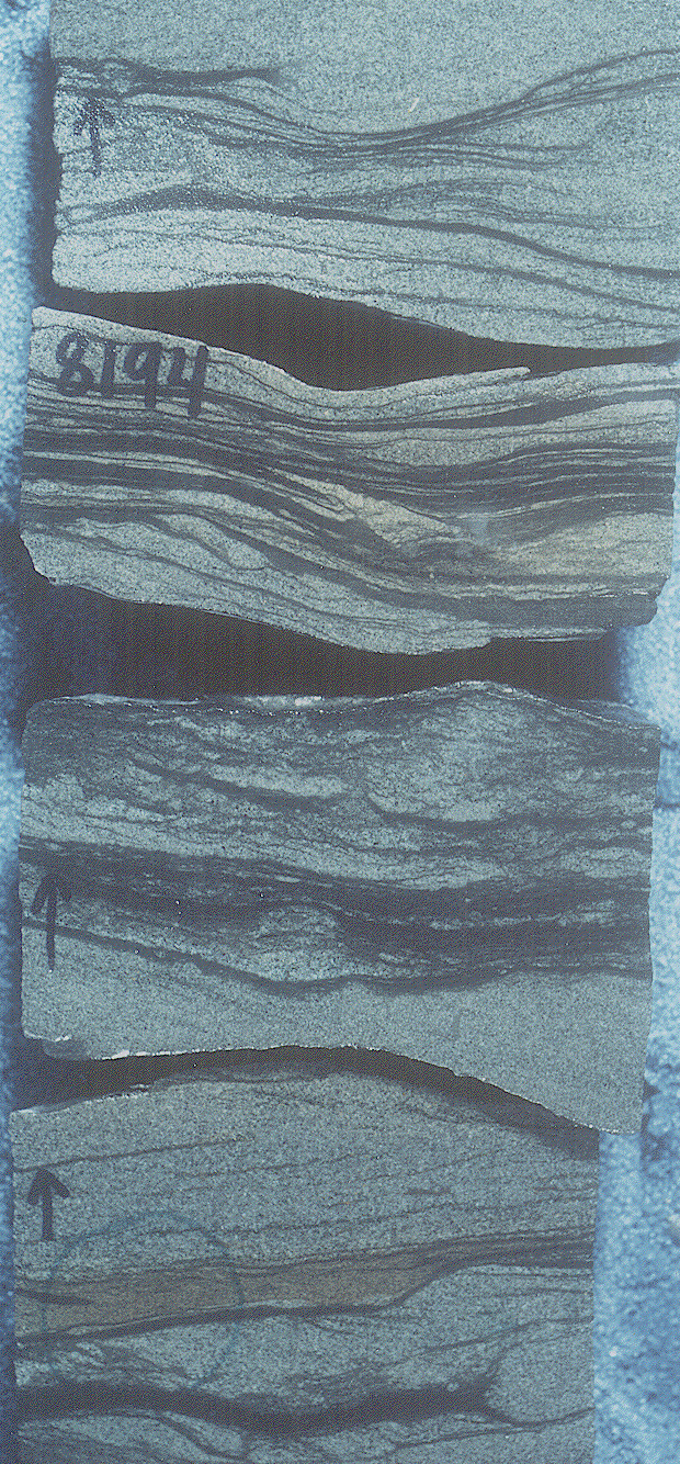
Figure 13. Core photograph of wavy-bedded fine-grained sandstone from 8,194 ft depth in the No. 1 Mandel-Federal well. Dark lines are mudstone laminae that segregate the thin, discontinuous sandstone beds. A siderite drape (arrow) is located on a ripple reactivation surface. Core width is 3.5 inches (9 cm). Arrows within core point up-hole. Wavy-bedded sandstone - 688 KB core (wss8194.gif) image.
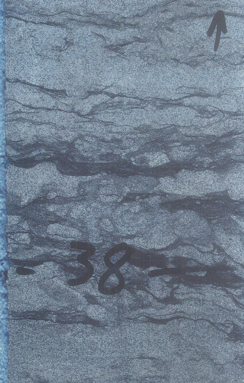
Figure 14. Core photograph of a bioturbated very fine grained sandstone from 8,038-ft depth in the No. 1 Empire Federal well. This facies exhibits very low porosity and low permeability and is a reservoir seal. Black arrow points to a mudstone lamina. Gold arrow shows a burrow trace. Core width is 2 inches. Bioturbated siltstone - 800 KB core (bss8038.gif) image.
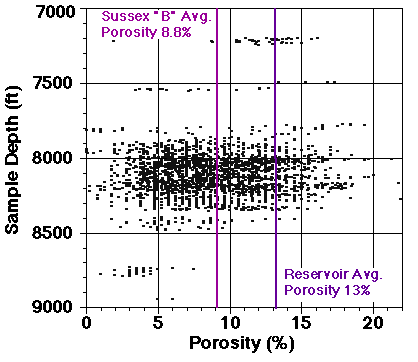
Figure 15. Graph of core and well-log porosity versus depth for 2,600 Sussex Sandstone Member points. The average 8.8 percent porosity of the Sussex "B" sandstone and of reservoir intervals (13 percent) is also plotted. Scatter in data is considerable.
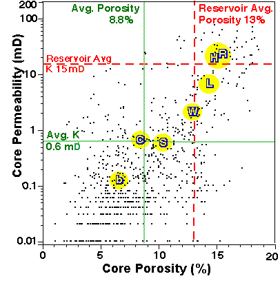
Figure 16. Volume percent porosity and permeability for 791 core plug samples for 30 wells, Sussex Sandstone Member (Higley, 1994). Greater porosity correlates with permeability increase. Scatter in data is considerable. Dotted green lines are geometric averages for this data of 8.8 percent porosity and 0.62 mD permeability. Dashed red lines represent average porosity and permeability of 13 percent and 15 mD for reservoir intervals of the "B" sandstone. Yellow circles surround average porosity and permeability values for sand-ridge facies determined from core examination of 8 wells. Sandstone facies are: chert-pebble lag, C; central-ridge, R; high-energy ridge-margin, H; low-energy ridge-margin, L; wavy-bedded, W; inter-ridge sandstone, S; and burrowed inter-ridge sandstone and mudstone, b.
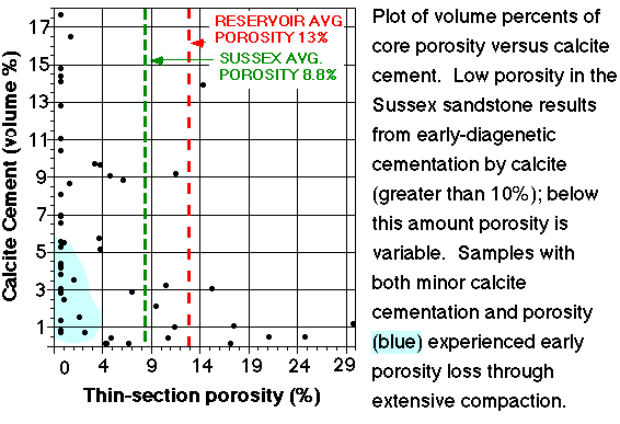
Figure 17. Plot showing volume percentages of core porosity and calcite cement for the Sussex "B" sandstone. Low-porosity sandstones associated with greater than 10 percent calcite cement commonly contain no effective porosity. This occurs mainly during the earliest stage of calcite cementation. The region with low porosity and minimal calcite cementation results from early diagenetic compaction. These samples are primarily burrowed and bioturbated sandstone and mudstone.
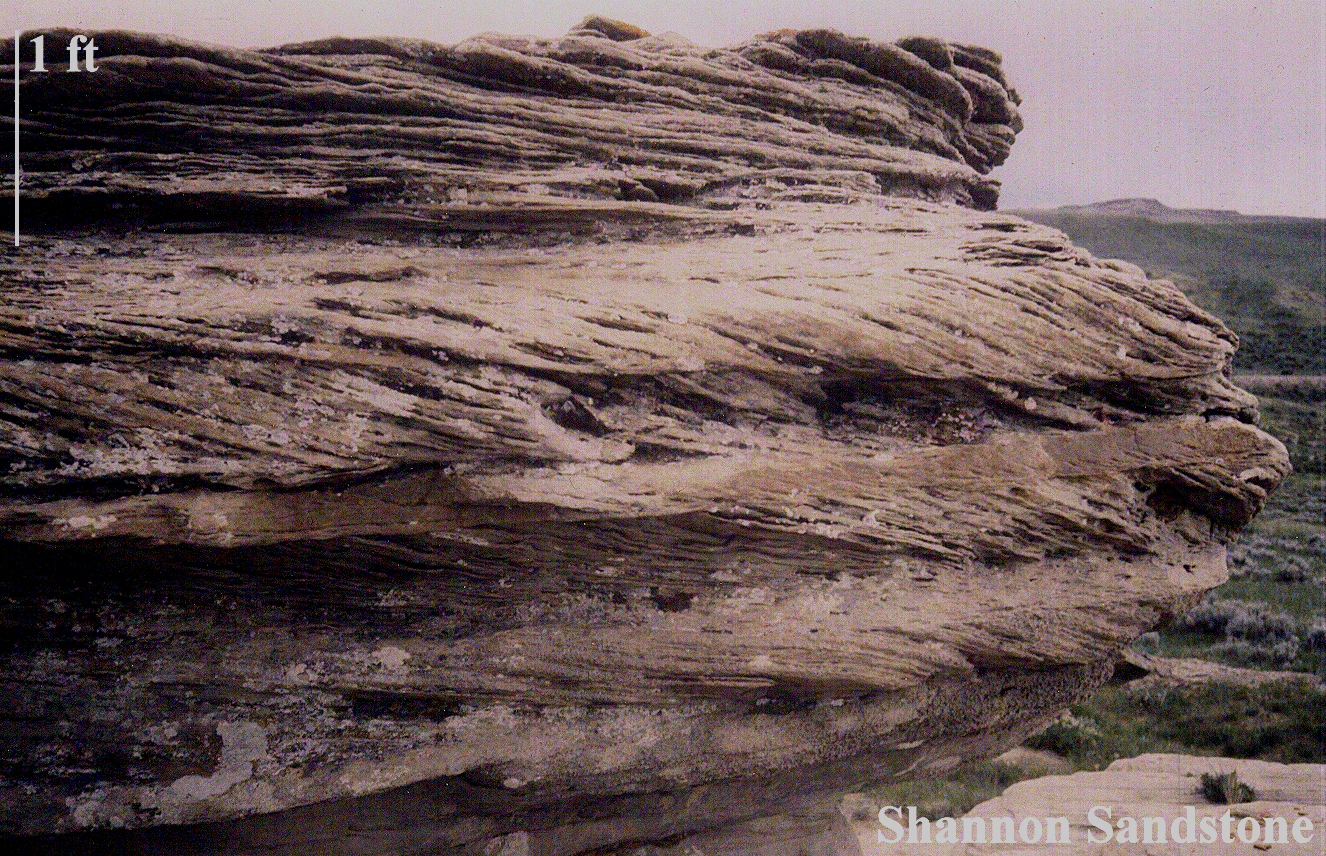
Figure 18. This outcrop of a Shannon Sandstone Member trough-cross-bedded sandstone is located at Shepperson Ranch, west of Midwest and Edgerton, Wyoming (figure 1). The thin, low-porosity, quartz-cemented beds are outlined in purple in this small-scale view. Porous and permeable intervals are bounded by a blue line. The 1.2 MB image is named snncrp1.gif .
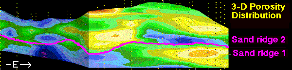
Figure 19. Illustrated are the lensate form of the reservoir, and of individual reservoir sandstones, in this vertical east-west slice showing 3-D distribution of porosity across sand ridge 1 and overlying sand ridge 2. Yellow dots are locations of well-log porosity measurements. Blue and purple areas are primarily non-reservoir intervals. These are basal and landward low-depositional-energy sandstones and mudstones of individual sand ridges (porosity ranges up to 8 percent). Green areas are reservoir-grade porosity of 8 to 12 percent. The breakover point between green and yellow is average porosity of reservoir intervals of about 12 percent; yellow through red (20 percent porosity) are the best-quality reservoir intervals. These are largely the medium-grained trough-cross-bedded sandstones, although even here there is considerable interbedding of low- through high-depositional-energy facies. Width of the reservoir at this slice is about 2 mi (4 km). Vertical exaggeration is 60x. This is 3dewlens.gif, slice 10 of the 3-D distribution of porosity model, as shown in the ewporosv.MOV movie.
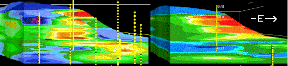
Figure 20. East-west oriented vertical slices of porosity (left, percent) and permeability (right, mD). This image (porpermv.gif) shows the highly variable porosity (left) and permeability (right) using core data. Porosity values/colors are reservoir grade (green through red) of 8 through 21 percent, and below-reservoir-grade low-porosity (blue) of less than 8 percent. Permeability ranges are: purple and blue, up to 5 mD; green, 5 to 16 mD; and yellow through red are greater than 16 mD. Average permeability of Sussex "B" reservoir sandstones is 15 mD. The close-spaced 3-D grid essentially treats each well as a separate set of points for the purpose of showing the variation in porosity and permeability. The various diamond shapes and streaks of low through high porosity and permeability illustrate the interbedding of thin beds of reservoir- and non-reservoir-grade sandstone and mudstone. These diagrams include the eastward and upward increases in porosity and permeability, and stacking of sand ridges shown in previous images. This slice is located in the northwestern half of the field. Yellow dots are (left) core and well-log and (right) core sample locations. Slices are 1.8 mi (2.8 km) wide and 50 ft (15 m) high. Vertical exaggeration is 30x. Respective names of the east-west porosity and permeability slide-image files are 3dew_img.htm and 3dvk_img.htm .
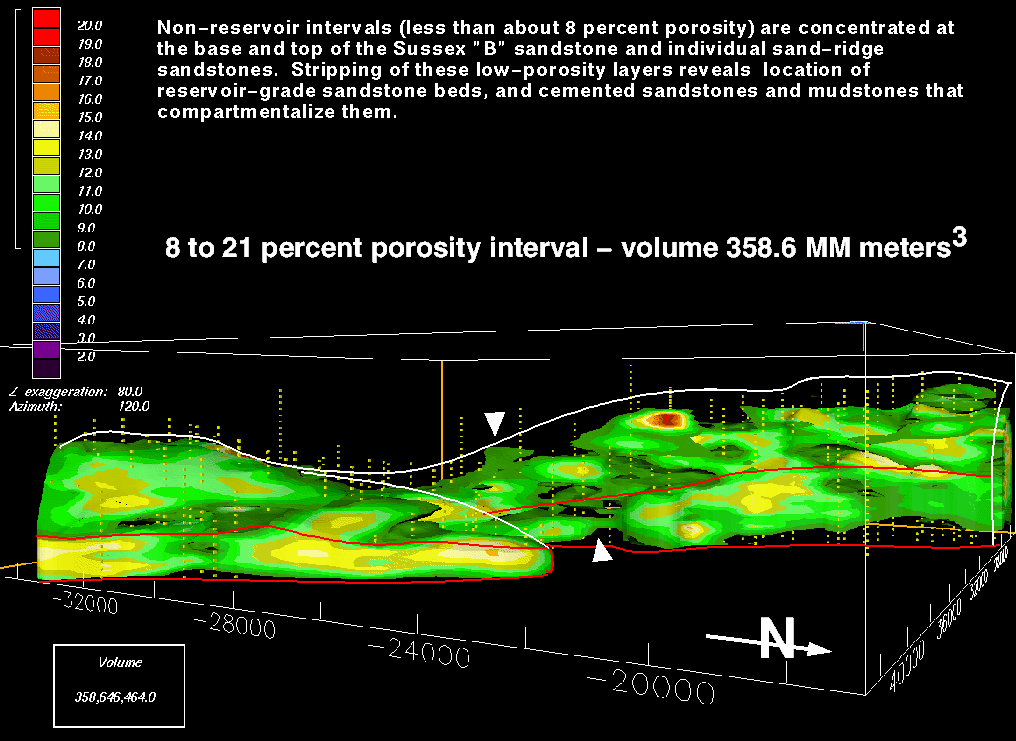
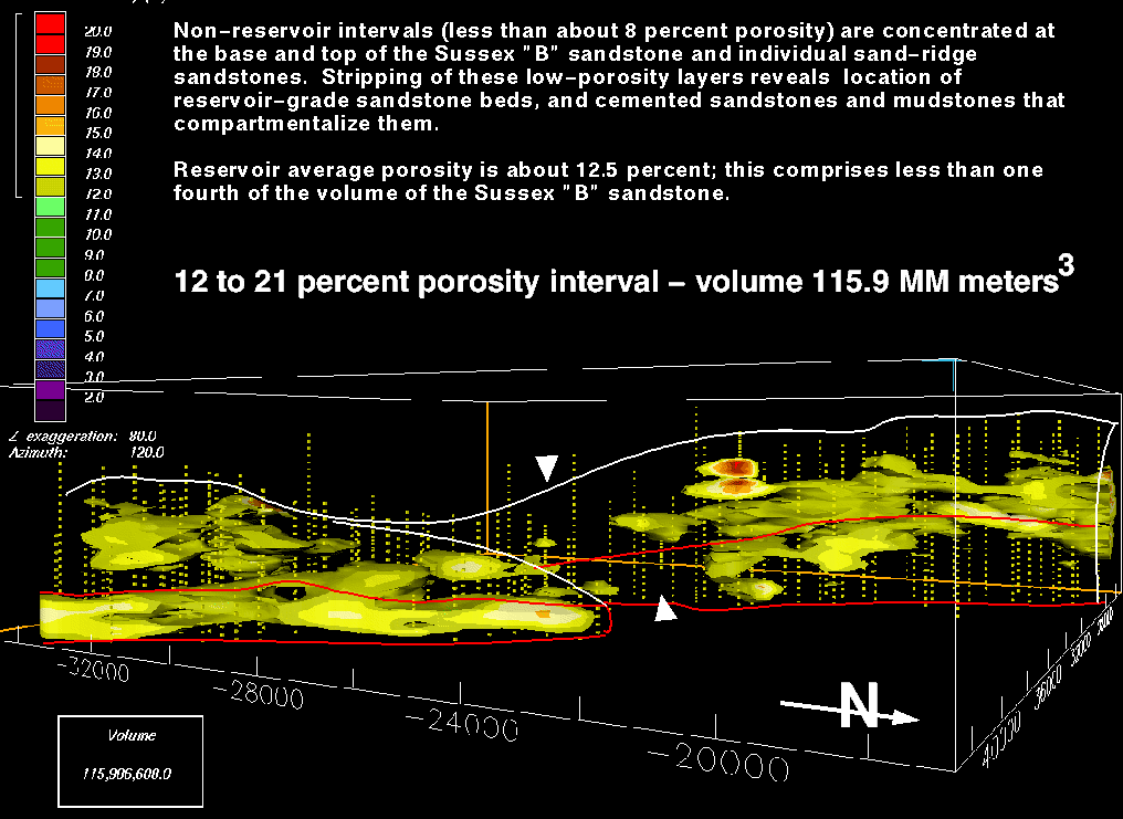
A. 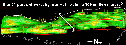
B. 
Figure 21. A. This (por8vol.gif) 3-D view of 8 to 21 percent porosity exhibits a total volume of 358.6 million cubic meters. This is about 70 percent of the total volume of 525.5 million cubic meters of the Sussex "B" sandstone within the field boundaries. The 64 KB full-size image is named eside10f.gif . B. This (por12vol.gif) 3-D image of 12 to 21 percent porosity has a total volume of 115.9 million cubic meters, which comprises less than 25 percent of the total volume of the "B" sandstone in the field. In comparison, the 13 to 21 percent porosity range is about 62.2 million cubic meters; this is about 12 percent of the field volume. The 64 KB full-size image is named eside10j.gif . Green on the figures is 8 to 12 percent porosity. Yellow through red are 12 to 21 percent porosity. Blue arrow marks the boundary between sand ridge 1 and 2. The thin white line marks the upper disconformity surface of the "B" sandstone, except for the seaward margin of the House Creek field, which is outlined in red. The white arrows and line separate the northwestern and southeastern ridge systems; the gap in reservoir-grade porosity units is apparent. X and Y scales are shown in meters around the base of the block. Maximum thickness of the "B" sandstone is about 60 ft (18 m). North arrow is included. Vertical exaggeration is 80x.
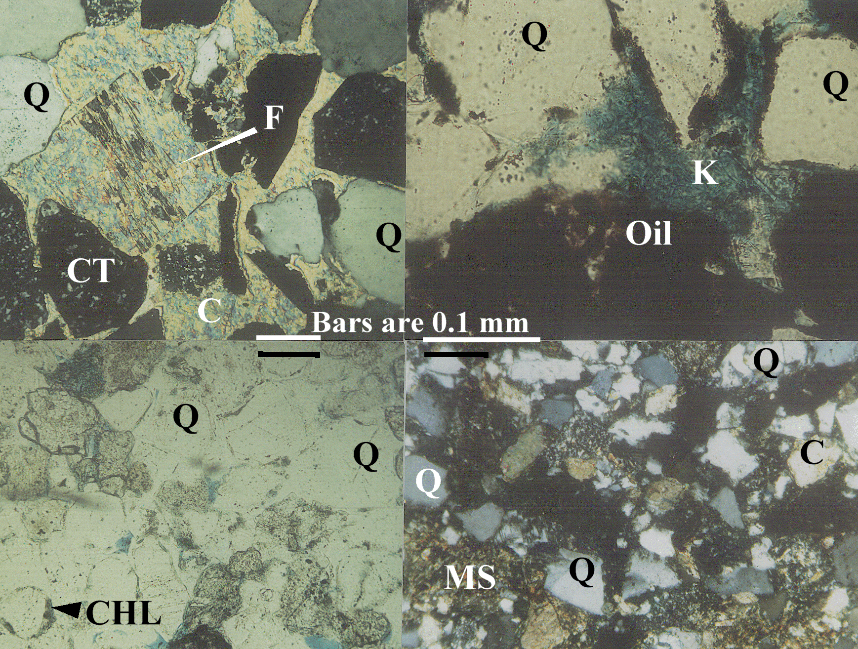
Figure 22. Thin-section photomicrographs of four samples of the Sussex "B" sandstone. Q is quartz, CT shows the chert grains, K is kaolinite, C is calcite, F shows feldspar grain (gray in the crossed-nicols view), MS are mudstone pore-fill and clasts, Oil coats grains and fills pores. Blue epoxy fills pore spaces. cmts4.gif is the full large-scale 2.4 MB image. Clockwise from upper left, images show;
- Absence of porosity and permeability resulting from precipitation of ferroan calcite (C), linked with dissolution of a feldspar (F) grain and peripheral dissolution of quartz (Q) and chert (CT) grains (cross-nicols light).
- Microporosity in an oil-stained, medium-grained sandstone resulted from late-diagenetic precipitation of kaolinite (K) in pore spaces (transmitted light).
- Low-depositional-energy facies have high levels of compaction with associated low levels of minus-cement porosity. Quartz grains frequently show peripheral dissolution and only minor overgrowths (crossed-nicols light).
- Pervasive cementation by quartz is most common in thin-bedded, "clean," well-sorted sands with minimal evidence of prior cementation by calcite. Chlorite (green) rims some quartz grains. Because of the early cementation by quartz, mudstone clasts frequently exhibit only minor compaction. Porosity (blue) is minor (transmitted light).
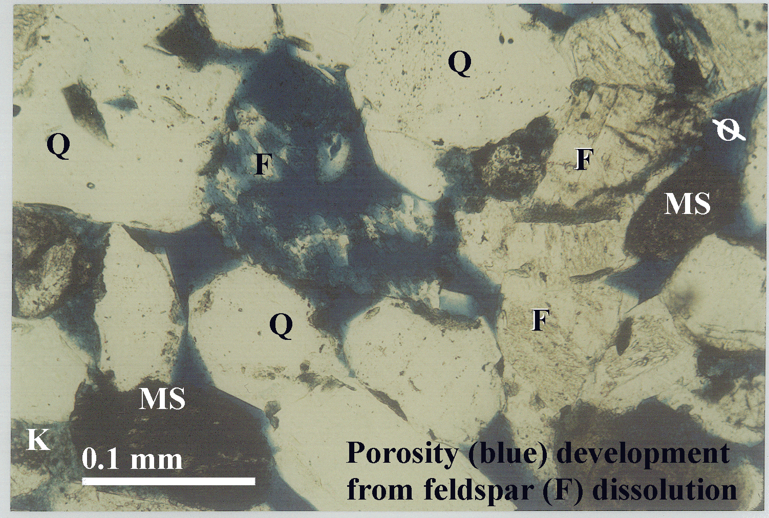
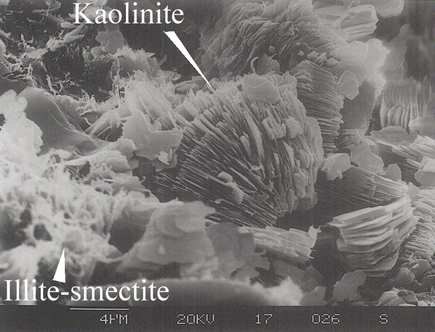
Figure 23. A. Thin-section photomicrograph from 8,012 ft (2,442 m) depth, No. 1 Empire Federal "C" well (fdissols.gif). Dissolution of the large feldspar (F) grain, located near the center of the image, results in secondary porosity. The crystal structure and outline of the feldspar grain is still apparent. Primary (depositional) porosity borders this and other grains. Quartz grains are labeled Q. Microporosity results primarily from breakdown of feldspar into kaolinite (K on large-scale view) and other clay minerals; this causes a mottled appearance of the blue epoxy that fills pore spaces. MS is a mudstone clast. Scale bar is 0.1 mm. The full-scale 1.5 MB thin-section photomicrograph of feldspar dissolution is fdissol.gif. B. Scanning electron microscope (SEM) image of kaolinite shows partings between booklets and minor amounts of "wispy" illite-smectite clay from the No. 1-23 House Creek Federal well (semkaosm.gif). Scale bar, below the illite-smectite label, is 4 micrometers. The 656 KB SEM full-scale image of kaolinite booklets is semkao.gif.
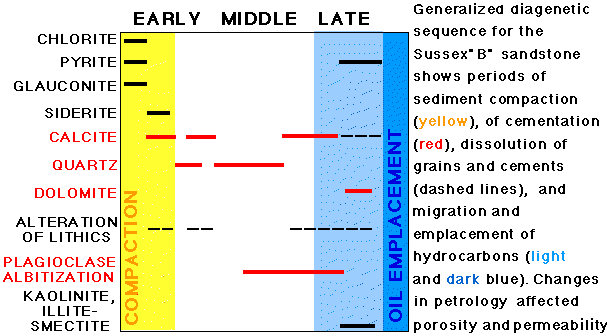
Figure 24. Generalized paragenetic sequence of the Sussex "B" sandstone (diagenes.gif). Dashed lines indicate times of dissolution of cements or grains. Yellow zone is period of sediment compaction. Medium blue zone is period of migration of hydrocarbons from shale source rocks. Dark blue zone is time of oil emplacement into the House Creek and Porcupine fields.
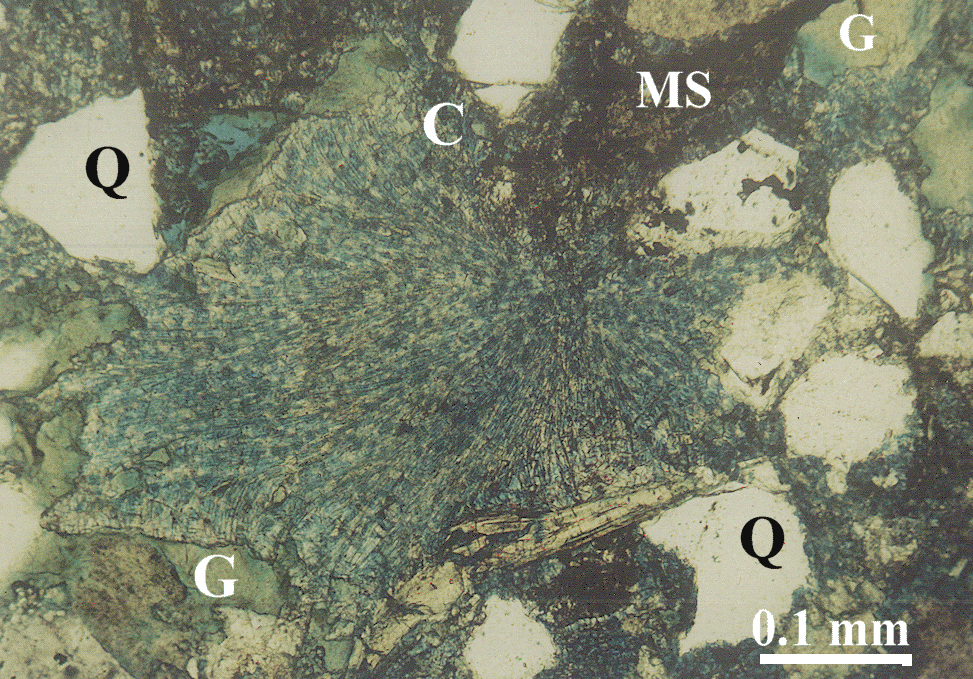
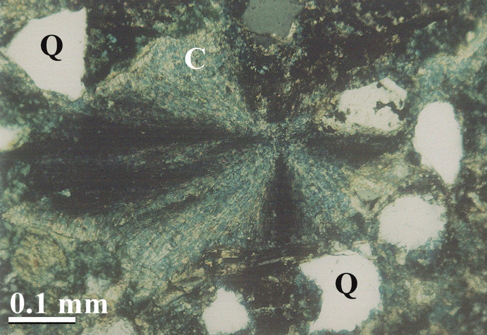
Figure 25. A. Transmitted-light view of very early diagenetic radial-fibrous calcite (C) that displaced quartz (Q) grains and glauconite. Calcite precipitated within the glauconite pellet and blasted it apart. Grains float in the matrix of calcite cement and mudstone (MS). Rfca1.gif is the full 752 KB transmitted-light image. B. The star-pattern of the calcite is apparent on this plane-polarized view. Rfca.gif is the full 736 KB plane-polarized image. Blue color results from staining the thin section for ferroan calcite.
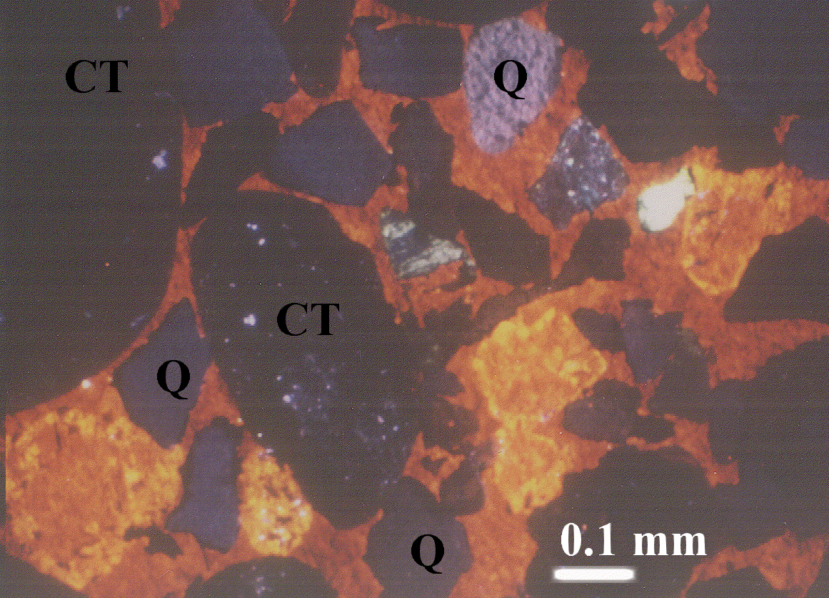
Figure 26. Cathodoluminescent photomicrograph of ferroan calcite cement (orange and bright orange) within a chert-pebble lag. Calcite is optically continuous across this view. Grains of chert (CT), quartz (Q), and feldspar (striped grain) float in a matrix of calcite cement. The feldspar grain is partially replaced by this very early diagenetic calcite. Bimodal grain distribution and point contacts between grains are also shown. clumcmt.gif is the full-scale 736 KB image. Quartz overgrowths are black (visible on the full-scale image). Scale bar is 0.1 mm.
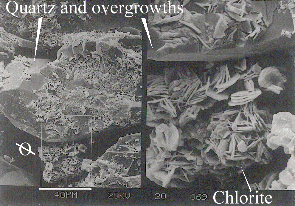
Figure 27. Scanning electron microscope (SEM) images of early-diagenetic chlorite rims (bladed crystals) that coat quartz grains and are intergrown with quartz overgrowths, No. 14-9 Federal well. Brown box shows location of the zoomed-in image. A pore space is labeled (ellipse with a line through it). Semchl.gif is the full-scale 768 KB image.
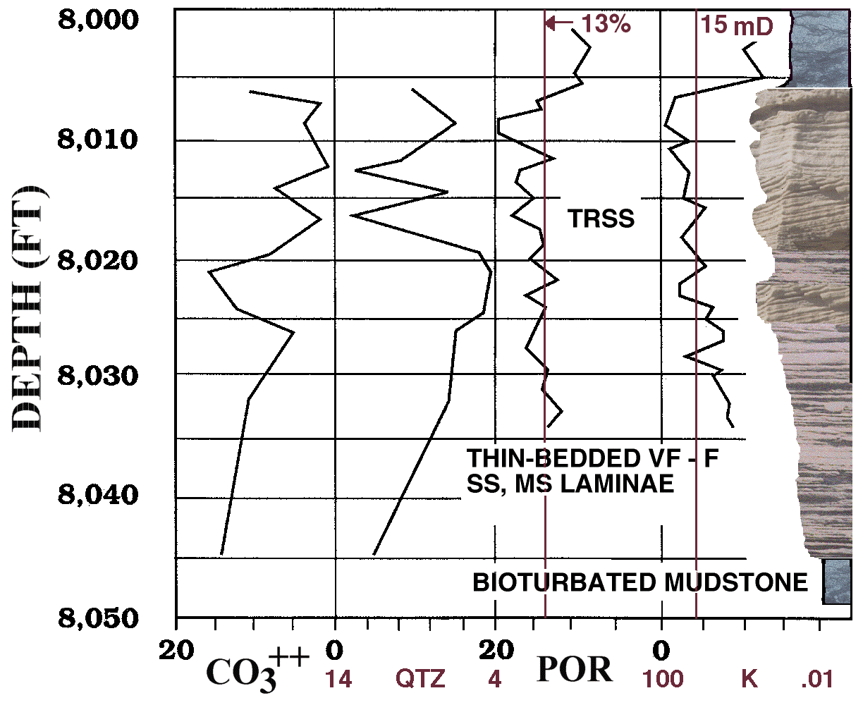
Figure 28. Shown are 1) 20 to 0 percent calcite (CO3++) and 14 to 4 percent quartz (QTZ) cements, 2) 20 to 0 percent core porosity (POR), 3) 100 to 0.01 mD permeability (K), and 4) photographs showing facies for the Sussex "B" sandstone, Empire Federal "C" oil well. TRSS is trough-cross-bedded sandstone intervals; these are concentrated near the top of the "B" sandstone and are the primary reservoir facies. "THIN-BEDDED VF-F SS, MS LAMINAE" refers to the thin-bedded horizontally stratified fine-grained sandstone and interbedded mudstone. Bioturbated mudstone is the blue-gray-colored rock located mainly at the base and top of this section. Heavy vertical bar on the right side of the figure is the perforated zone. The full-scale 144 KB image is empfedsr.gif.
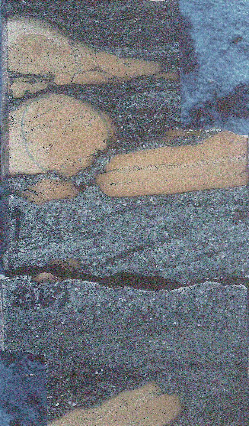
Figure 29. Core photograph (trs8167s.gif) from 8,167-ft depth in the Mandel Federal "C" well shows siderite clasts that were ripped up by high-energy currents and redeposited on the trough-cross-bedded sands of submarine dunes. Original horizontal bedding is shown in clasts by the stringers of quartz grains. The full-scale trs8167.gif image is 992 KB.

Figure 30. Thin-section photomicrograph of a siderite clast in a chert-pebble lag, No. 14-1 Federal well, Porcupine field (foramsm.gif). Foraminifera tests in the clast that have been partially replaced by siderite (brown). Evidence for the marine origin of the siderite clasts includes alteration to siderite of Haplophragmoides and Reophax foraminiferal tests. The full-size foram.gif image is 768 KB.
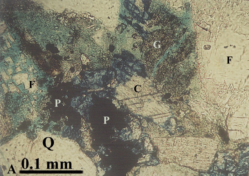
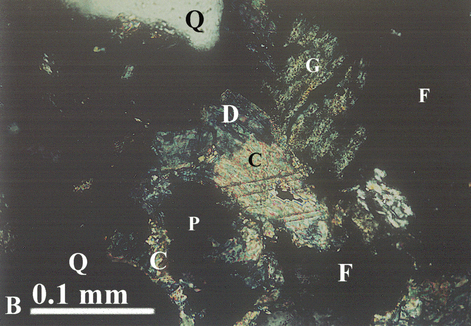
Figure 31. A. Transmitted-light and B. crossed-nicols thin-section photomicrographs of pyrite framboids (P) within ferroan dolomite (D) from a trough-cross-bedded sandstone at 8,014-ft (2,443 m) depth in the Empire Federal "C" oil well. Quartz (Q) and feldspar (F) grains bound optically-continuous calcite (C) cement. G is a glauconite pellet. Medium blue is epoxy and mottled blue results from kaolinite clay (transmitted light view), dark blue on both views is the late-diagenetic ferroan dolomite. Full-size transmitted-light image is 752 KB pyrca1.gif. Full-size crossed-nicols view is 784 KB pyrca2.gif.
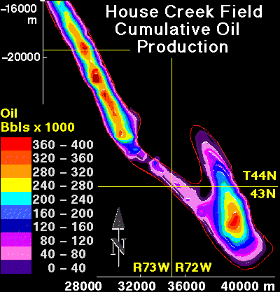
Figure 32. Contour map of cumulative oil production across the House Creek field area. Field is delineated by the red line. Contour interval is 40,000 barrels of oil. Map scale, in meters, is shown around the margin. Township and range line intersections are also drawn. Greatest production is proximal to field axes; these are also areas of stacked sand ridges; oil is commonly produced from 2 sandstone bodies separated by a permeability barrier. Porosity and permeability generally decrease west of the eastern margins of the field, so increase in production along the field axes is a function of thickest intervals of stacked sandstones with greatest porosity and permeability.
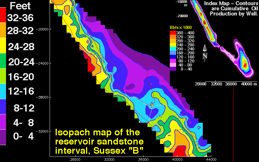
Figure 33. Sussex "B" sandstone isopach showing thickness in feet of the reservoir-grade sandstone interval. The House Creek field is delineated by red lines; the faint white lines outline sand ridge boundaries. Contour interval is 4 ft (1.2 m). Map scales are meters. In some areas, contours are extrapolated outside of data control. Reservoir sandstone intervals were determined by examining well-log traces of about 120 wells, as well as core and petroleum production data; boundaries correspond to a cut-off of about 8.5 percent porosity. This interval includes lower porosity sandstone and mudstone located within and between sand ridges. Index map is cumulative oil production across the field; contour interval is 40,000 barrels of oil (BO) for the range 0 to 400,000 BO. Resiso.gif is the large-scale 64 KB contour map of reservoir intervals.
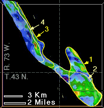
Figure 34. Plan-view map on the upper disconformity surface of the Sussex "B" sandstone within the House Creek field. Reservoir-grade intervals are shown by green through red (8 to 21 percent porosity); low-porosity non-reservoir intervals are purple through blue (1 to 8 percent porosity). Sand ridges 1 through 4 and field boundaries are delineated by yellow and tan; dashed lines separate townships and ranges. Basal sand ridges are 1 and 3.
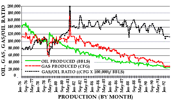
Figure 35. Production decline curve for monthly intervals from 1976 through August 1992 in the House Creek field. Oil (BBL), gas (CFG) and gas/oil ratio (GOR) curves are shown. GOR is multiplied by 100,000 to better view increase in through time of gas production relative to oil. Water production is not shown due to small volumes. Cumulative production to January 1976 was 8.73 MMB of oil and 4.06 MMCF of gas (Petroleum Information Corp. production data).
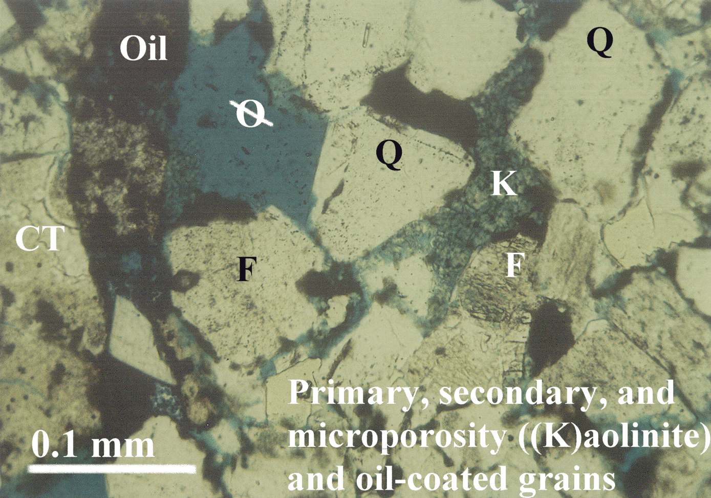
Figure 36. Transmitted-light thin-section photomicrograph of an oil-productive trough-cross-bedded, medium-grained sandstone from the House Creek field. Oil (brown) coats primary and secondary pore spaces. Spotty distribution of oil in the kaolinite (K) results from low permeability and microporosity. Feldspar (F) grain is partially dissolved. Quartz (Q) and chert (CT) grains are labeled. Blue epoxy fills pore spaces (ellipse with a line through it). The full-size photomicrograph is oilstn.gif, 1.4 MB .