Data Series 979
U.S. Department of the Interior
U.S. Geological Survey
Publications are available from USGS Information Services, Box 25286, Federal Center, Denver, CO 80225-0046 (telephone 1-888-ASK-USGS e-mail: infoservices@usgs.gov).
Contents: |
|
|
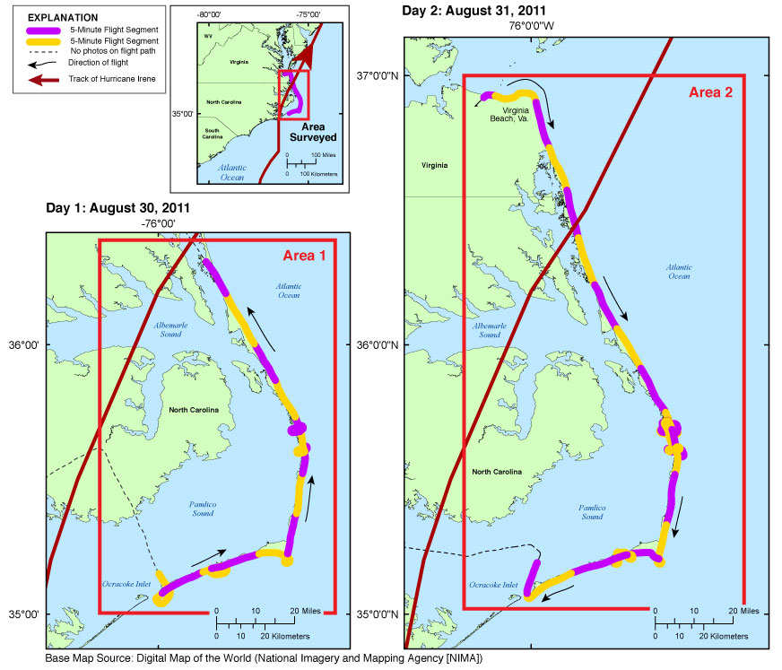
| Figure 1. Map showing the post-Hurricane Irene coastal oblique survey flight path from Ocracoke Inlet, North Carolina, to Virginia Beach, Virginia, August 30-31, 2011. Click in an area box to view a detailed map of that area. |
The U.S. Geological Survey (USGS), as part of the National Assessment of Coastal Change Hazards project, conducts baseline and storm-response photography missions to document and understand the changes in vulnerability of the Nation's coasts to extreme storms (Morgan, 2009). On August 30-31, 2011, the USGS conducted an oblique aerial photographic survey from Ocracoke Inlet, North Carolina, to Virginia Beach, Virginia (Figure 1), aboard a Piper Navajo Chieftain (aircraft) at an altitude of 500 feet (ft) and approximately 1,200 ft offshore (Figure 2). This mission was flown to collect post-Hurricane Irene data for assessing incremental changes in the beach and nearshore area since the last survey, flown in May 2008, and the data can be used in the assessment of future coastal change.
The photographs provided in this report are Joint Photographic Experts Group (JPEG) images. ExifTool was used to add the following to the header of each photo: time of collection, Global Positioning System (GPS) latitude, GPS longitude, keywords, credit, artist (photographer), caption, copyright, and contact information. The photograph locations are an estimate of the position of the aircraft at the time the photograph was taken and do not indicate the location of any feature in the images (see the Navigation Data page). These photographs document the state of the barrier islands and other coastal features at the time of the survey. Pages containing thumbnail images of the photographs, referred to as contact sheets, were created in 5-minute segments of flight time. These segments can be found on the Photos and Maps page. Photographs can be opened directly with any JPEG-compatible image viewer by clicking on a thumbnail on the contact sheet.
Table 1 provides detailed information about the GPS location, image name, date, and time for each of the 2,688 photographs that were taken along with links to each photograph.
In addition to the photographs, a Google Earth Keyhole Markup Language (KML) file is provided and can be used to view the images by clicking on the marker and then clicking on either the thumbnail or the link above the thumbnail. The KML also shows the track of Hurricane Irene (Unisys Weather, 2015). The KML files were created using the photographic navigation files. These KML file(s) can be found in the kml folder.
This report is divided into eight sections: Home, Abbreviations, Contents, Photos and Maps, Navigation Data, Logs, Metadata, and Citation Page. Links at the top and bottom of each page provide access to these sections.
Links to the full-sized images can be found through the Photos and Maps page and through Table 1. KML files, Hypertext Markup Language (HTML) files, images used to produce the Web pages, and a readme file are also included in this report. GPS data collected during the flight are also available on the Navigation Data page. The Logs page contains information on the flight and the equipment used. The Contents page contains a diagram of the location of all files and folders mentioned in the text and provides links to these files and folders.
Figure 2. Acquisition Geometry
Figure 3A. Area 1 - Ocracoke Inlet, North Carolina, to Duck, North Carolina.
Figure 3B. Area 2 - Virginia Beach, Virginia, to Ocracoke Inlet, North Carolina.
Figure 4. Rodanthe and Pea Island National Wildlife Refuge Inset Map (Area 1).
Figure 5. Rodanthe and Pea Island National Wildlife Refuge Inset Map (Area 2).
Figure 6. Hatteras Inset Map (Area 2).
Table 1 provides detailed information about the image name, GPS location, date, and time for each of the 2,688 photographs that were taken during this survey, along with links to each photograph and contact sheet.
Morgan, K.L.M., 2009, Coastal change during Hurricane Isabel 2003: U.S. Geological Survey Fact Sheet 2009-3025, 2 p., https://pubs.usgs.gov/fs/2009/3025/.
Unisys Weather, 2015, Hurricane/Tropical data, accessed July 2015 at http://weather.unisys.com/hurricane/atlantic/2011H/IRENE/track.dat
Morgan, K.L.M., and Krohn, M.D., 2016, Post-Hurricane Irene coastal oblique aerial photographs collected from Ocracoke Inlet, North Carolina, to Virginia Beach, Virginia, August 30-31, 2011: U.S. Geological Survey Data Series 979, https://dx.doi.org/10.3133/ds979.
ISSN 2327-638X (online)
Funding and support for this study was provided by the USGS Coastal and Marine Geology Program (CMGP). The authors wish to thank pilot, Mitch Bobowski, for his assistance in data collection. This report benefited from the comments and reviews of Bryan McCloskey and Kara Doran with the USGS.
This report was prepared by an agency of the United States Government. Although these data have been processed successfully on a computer system at the U.S. Geological Survey (USGS), no warranty expressed or implied is made regarding the display or utility of the data on any other system, nor shall the act of distribution imply any such warranty. The USGS shall not be held liable for improper or incorrect use of the data described and (or) contained herein. Reference herein to any specific commercial product, process, or service by trade name, trademark, manufacturer, or otherwise does not constitute or imply its endorsement, recommendation, or favoring by the United States Government or any agency thereof.
The minimum software requirements are a Web browser, a Portable Document Format (PDF) reader, and a text editor. Additional features are provided using Google Earth software (http://www.google.com/earth/download/ge/). If you cannot fully access the information on this page, please contact USGS Information Services at infoservices@usgs.gov or 1-888-ASK-USGS.
NOTE: Adobe Acrobat Reader or similar software is required to view PDF documents.
Karen L.M. Morgan
U.S. Geological Survey
St. Petersburg Coastal and Marine Science Center
600 4th Street South
St. Petersburg, FL 33701
Ph: (727) 502-8037
Fax: (727) 502-8182
kmorgan@usgs.gov

![]() U.S. Department of the Interior |
U.S. Geological Survey
U.S. Department of the Interior |
U.S. Geological Survey
URL: http://pubsdata.usgs.gov/pubs/ds/0979/index.html
Page Contact Information: GS Pubs Web Contact
Page Last Modified: Monday, 28-Nov-2016 20:44:17 EST
