USGS - science for a changing world

Data Series 1077


Chirp Subbottom Profile Data Collected in 2015 From the Northern Chandeleur Islands, Louisiana

Skip Links

Citation Page
Abstract
Introduction
Survey Overview and Data Acquisition
Data Processing
Data Downloads
Abbreviations
References Cited
 

Data Downloads

The seismic data described in this report, including field logs, trackline locations, navigation, and GIS data files with accompanying Federal Geographic Data Committee (FGDC) metadata, can be downloaded from Forde and others (2018) or by using the table below. Additionally, the seismic profiles can be viewed by clicking on the trackline name listed on the location map (fig. 4).

Field Activity Collection System (FACS) geophysical operations logs are provided as Portable Document Format (PDF) files and can be viewed using the free software Adobe Reader. Digital FACS and field logs were generated from field notes and logbooks. The chirp subbottom profiles are provided as GIF images and can be viewed using standard image viewing software. The trackline navigation data are provided as ASCII text files (.txt) and GIS data files in Esri shapefile (.shp) format; the GIS files can be opened using the free software Explorer for ArcGIS. GIS data files are referenced to the WGS84 geographic coordinate system.

Figure 4.	Location map of all digital subbottom profile data collected during USGS field activity 2015-331-FA, tracklines represent the vessel position during the survey
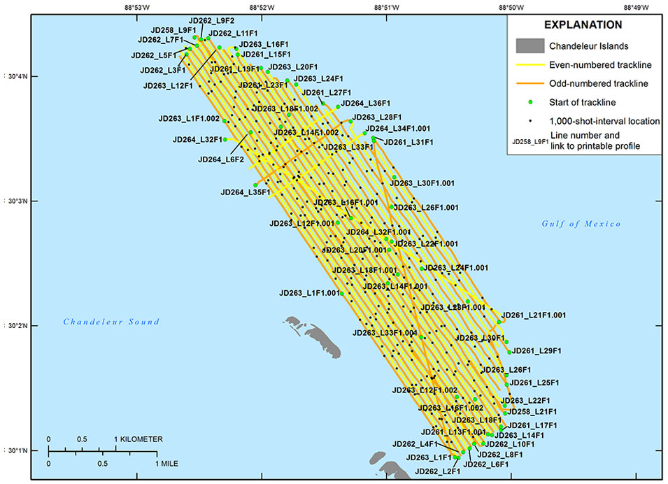
Figure 4. Figure 4. Location map of all digital chirp subbottom profile data collected during U.S. Geological Survey (USGS) field activity 2015-331-FA. Tracklines represent the vessel position during the survey. Click on a line number to view each subbottom profile (.gif format). This map uses the World Geographic System of 1984 (WGS84) coordinate system. Land area was derived from USGS light detection and ranging (lidar) data collected in 2015 (USGS, 2017).

Data Download Table

File name and description Metadata (XML format) Metadata (text format) Download file
2015-331-FA_segy.zip
Unprocessed digital chirp subbottom trace data (.sgy)
2015-331-FA_metadata.xml 2015-331-FA_metadata.txt 2015-331-FA_segy.zip
(6.3 GB)
2015-331-FA_nav.zip
Navigation data (.txt)
Same as above Same as above 2015-331-FA_nav.zip
(4.2 MB)
2015-331-FA_seisimag.zip
Processed subbottom profile images (.gif)
Same as above Same as above 2015-331-FA_seisimag.zip
(46.3 MB)
2015-331-FA_arc.zip
Survey trackline locations (.mxd, .shp)
Same as above Same as above 2015-331-FA_arc.zip
(1.6 MB)
Supplemental information
2015-331-FA_logs.zip
Field Activity Collection System (FACS) and geophysical operations logs (.pdf)
Not applicable Not applicable 2015-331-FA_logs.zip
(192 KB)

Accessibility FOIA Privacy Policies and Notices

Take Pride in America logo USA.gov logo U.S. Department of the Interior | U.S. Geological Survey
URL: http://pubsdata.usgs.gov/pubs/ds/1077/ds1077_data_downloads.html
Page Contact Information: GS Pubs Web Contact
Page Last Modified: Thursday, 01-Feb-2018 08:58:46 EST

JD262_L9F2.gif JD262_L11F1.gif JD262_L7F1.gif JD263_L1F1.001.gif JD263_L12F1.001.gif JD264_L35F1.gif JD264_L6F2.gif JD264_L32F1.gif JD263_L1F1.002.gif JD263_L12F1.gif JD258_L9F1.gif JD262_L5F1.gif JD263_L14F1.002.gif JD264_L32F1.001.gif JD263_L26F1.gif JD261_L13F1.001.gif JD263_L1F1.gif JD262_L2F1.gif JD262_L4F1.gif JD261_L15F1.gif JD263_L16F1.gif JD261_L29F1.gif JD263_L20F1.gif JD263_L18F1.001.gif JD263_L24F1.gif JD261_L27F1.gif JD263_L30F1.gif JD264_L36F1.gif JD263_L28F1.gif JD263_L22F1.001.gif JD264_L34F1.001.gif JD261_L21F1.001.gif JD261_L31F1.gif JD261_L25F1.gif JD263_L30F1.001.gif JD263_L12F1.002.gif JD263_L16F1.002.gif JD261_L23F1.gif JD263_L18F1.002.gif JD263_L22F1.gif JD261_L19F1.gif JD263_L14F1.001.gif JD258_L21F1.gif JD263_L18F1.gif JD263_L33F1.001.gif JD263_L20F1.001.gif JD263_L26F1.001.gif JD263_L24F1.001.gif JD263_L16F1.001.gif JD263_L28F1.001.gif JD263_L33F1.gif JD261_L17F1.gif JD262_L6F1.gif JD262_L8F1.gif JD262_L10F1.gif JD263_L14F1.gif JD262_L3F1.gif