Data Series 1077
| Survey Overview and Data AcquisitionUSGS scientists collected high-resolution geophysical data offshore of the northern Chandeleur Islands, Louisiana, during a survey conducted between September 14 and 28, 2015 (Field Activity Number [FAN] 2015-331-FA), onboard the research vessel (R/V) Sallenger. The primary goal of the survey was to acquire interferometric swath bathymetry and high-frequency (chirp) subbottom data in the shallow, submerged areas surrounding the northern Chandeleur Islands. These data can be used to help investigate interannual changes to the island platform, specifically seafloor morphology. A particular area of interest during this study was the borrow pit, located southeast of Hewes Point, whose sediments were used to create the sand berm constructed in 2011 as mitigation of the Deepwater Horizon oil spill. A total of 57 seismic lines (Forde and others, 2018) and 53 bathymetric lines (Fredericks and others, 2016) were collected. NavigationDifferential global positioning system (DGPS) correction was obtained through the Marinestar high precision (HP) broadcast subscription from Fugro, Inc., which has a manufacturer's stated horizontal accuracy of 10 centimeters (cm). To ensure consistent spacing between survey lines (for example, 5 meters [m] in the nearshore and 10 m for offshore lines), pre-determined trackline locations were imported into Hypack 15.0.1.1 navigation software and followed during seismic data collection. As the subbottom data were acquired, vessel position was recorded in real-time kinematic mode via the CodaOctopus F190R+ Precision Attitude and Positioning System, which integrates the Marinestar position data with measured vessel heave, pitch and roll. Positions from the CodaOctopus F190R+ inertial aided navigation system (IANS) were recorded and written to seismic trace headers in latitude and longitude coordinates (World Geodetic System of 1984 [WGS84]) every 1 second (s). The approximately 3.6-m offset between the chirp shot and the ship's DGPS was not accounted for during acquisition; consequently, the trackline map and navigation files provided represent the vessel position during the survey. Additional information about the navigation system can be found in table 1 and the Field Activity Collection System (FACS) logs. To view the trackline map and navigation files and for more information about these items, see figure 4 and Forde and others (2018). Seismic DataSubbottom profile data were collected using an EdgeTech SB-424 chirp towfish running Discover acquisition software (version 3.51) and towed on the port side of the R/V Sallenger, approximately 3.5 m opposite the global positioning system (GPS) antenna. All chirp systems use a signal of continuously varying frequency and produce high-resolution, shallow-penetration (typically less than 75 milliseconds [ms]) profile images of sub-seafloor stratigraphy. The towfish contains a transducer that transmits and receives acoustic energy and typically is towed within 1 m of the sea surface. This process is repeated at regular intervals (for example, 0.125 s), and returned energy is recorded for a specific duration (for example, 50 ms). In this way, a two-dimensional (2D) vertical image of the shallow geologic structure beneath the ship's track is produced. Figure 3 displays the acquisition geometry for this survey (FAN 2015-331-FA). Refer to table 1 for a summary of acquisition parameters. The unprocessed chirp seismic data were acquired in standard Society of Exploration Geophysicists (SEG) SEG Y rev. 0 format (Barry and others, 1975). A detailed description of the data format can be found at https://seg.org/Publications/SEG-Technical-Standards. The seismic data files are binary encoded and cannot be viewed directly; however, they may be downloaded and processed with commercial or public-domain software. The SEG Y files are available from Forde and others (2018), via the USGS Coastal and Marine Geoscience Data System (https://cmgds.marine.usgs.gov), and are also available for viewing using GeoMapApp (http://www.geomapapp.org) and Virtual Ocean (http://www.virtualocean.org) multi-platform open source software. Table 1.Field Activity Number (FAN) 2015-331-FA chirp data acquisition parameters.
[IANS, inertial aided navigation system; JD, Julian Day; kHz, kilohertz; m, meter; milliseconds, ms; s, seconds]
*Shot spacing was highly variable and was based on a survey speed of approximately 3.5 knots.  Figure 2. Photograph of the EdgeTech SB-424 chirp towfish being set up for deployment by a U.S. Geological Survey technician. [Click figure to enlarge]
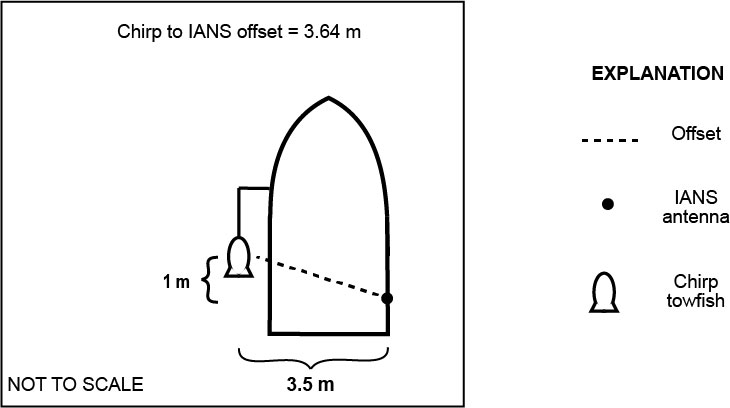 Figure 3. Diagram showing chirp acquisition geometry on the research vessel (R/V) Sallenger for field activity 2015-331-FA. Position data were collected with an inertial aided navigation system (IANS); distance is in meters (m). [Click figure to enlarge] |

![]() U.S. Department of the Interior |
U.S. Geological Survey
U.S. Department of the Interior |
U.S. Geological Survey
URL: http://pubsdata.usgs.gov/pubs/ds/1077/ds1077_overview.html
Page Contact Information: GS Pubs Web Contact
Page Last Modified: Thursday, 01-Feb-2018 08:58:46 EST
