|
|
Introduction
This data release publication provides an improved and robust integrated database (usSEABED) of seabed characteristics for the Gulf of Mexico continental margin of the United States and the Caribbean (Puerto Rico and U.S. Virgin Islands) that fulfills a need for information about seabed characteristics for use by geologists, ecologists, biologists, resource managers, and national defense investigators. usSEABED provides a digital, integrated database of existing physical data and information from the sea floor, including textural, statistical, geochemical, geophysical, and compositional information. It uses the dbSEABED data mining and processing software to extend the coverage of information into areas where data coverage is more descriptive than quantitative. The data coverage includes the U.S. Gulf of Mexico waters from Port Isabel, Texas and the Mexican border to Key West, Florida, including Lake Ponchartrain, Mobile Bay, the coastal zones of Puerto Rico and the U.S. Virgin Islands, beaches, rivers and estuaries, and extends seaward across the continental shelf and slope. More than 112 different data sources containing over 200,000 data points are currently contained in usSEABED for the Gulf of Mexico and Caribbean.
The usSEABED data in DS 146 are an integral component of the Louisiana Sedimentary and Environmental Database (LASED), a combined effort of the USGS and academic researchers to assemble and manage decades of geologic data collected from studies in the Louisiana coastal zone. The development of the geodatabase is in response to a growing need for the USGS and collaborators to efficiently access coastal geologic data for coastal zone management issues. The database incorporates a wide range of data types: sediment-sample descriptions and analyses, geophysical profiles, raster-image basemaps, and logbooks. The data are integrated with spatial and attribute information to provide processing and visualization capabilities using standard GIS and Web browsing tools. The data types are linked so that complex queries and analyses can be performed across datasets. Decades-old to recently acquired analog data are included through the use of new technology and processing techniques, so that the database serves as a gateway to an interactive online digital archive system.
LASED is a component of the Oracle geodatabase system maintained at the USGS St. Petersburg center. The geodatabase is accessible to registered users through ESRI's ArcGIS desktop software. Presently, limited functionality of LASED is also available via the Internet to registered users using a standard Web browser at: http://coastal.er.usgs.gov/lased/. USGS collaborators interested in accessing the LASED database can contact James Flocks at jflocks@usgs.gov .
This data-series publication is the third in a set of similar publications that cover the entire Exclusive Economic Zone of the United States (U.S. EEZ). Available now are the companion publications of usSEABED data from the Atlantic (Reid and others, 2005) and the Pacific Margins (Reid and others, 2006). Planned companion publications will include data for the Alaskan margin and Hawaii. These publications will be updated as significant amounts of new data are included in usSEABED. This publication contains information on the usSEABED data collection, the dbSEABED program and processing, as well as a Data Catalog where the data are included (within compressed files) as GIS layers and comma-delimited text files.
The overall usSEABED database holds data for the entire U.S. EEZ and is an ongoing task of the Marine Aggregates Resources and Processes and National Benthic Habitats Studies (Pacific) projects, carried out by the USGS Coastal and Marine Geology teams in Santa Cruz, CA, Woods Hole, MA, and St. Petersburg, FL, and the University of Colorado.
As a caution in using the usSEABED database in depicting seabed sedimentary character or creating sea floor geologic maps, users should be aware that all sea floor regions are by their nature dynamic environments and subject to a variety of physical processes such as erosion, winnowing, reworking, and sedimentation or accretion that vary on different spatial and temporal scales. In addition, as with any such database, usSEABED is comprised of samples collected, described and analyzed by many different organizations and individuals over a span of many years, providing inherent uncertainties between data points. Plotting the data can also introduce uncertainties that are largely unknown at this time. In addition, there are uncertainties in data quality associated with both the extracted data (numeric/ analytical analyses) and parsed data (word-based descriptions). The authors are aware that on occasion grain-size analyses are done solely on the sand fraction, excluding coarse fractions such as shell fragments and gravel, while word descriptions of sediment samples can emphasize or de-emphasize the proportion of fine or coarse sediment fraction, or disregard other important textural or biological components. The authors have done their best to select the best quality data for inclusion in usSEABED and encourage users to view the provided metadata files for information about individual sources' limitations, date of collection, and other pertinent information.
Back to Top
Future Plans, Updates and Online Usage in a GIS
It is expected that usSEABED will continue to expand throughout the U.S. EEZ by the incorporation of new data sets and by the utilization of the data in new and different ways. As significant changes are made, we expect to reissue updated usSEABED.
Data contributions and (or) additional partners are welcomed. For information, please see the contacts page.
Published usSEABED data from this region and others are accessible online (using ESRI® ArcIMS) at http://coastalmap.marine.usgs.gov/regional/contusa/. Data layers will also be submitted for viewing and downloading through Geodata.gov.
Applications
The usSEABED database is a very large compilation, containing complex assortments of data and geologic information on the geology of the sea floor. Although these database was developed for use in conducting studies of offshore sedimentary character for assessing marine aggregates and characterizing benthic habitats, it has potential for much greater application by the marine science community and other users. Users are encouraged to generate their own queries and extract information to meet specific needs. Other possible applications for data and maps from usSEABED follow:
- Research ocean observation and monitoring
- Coastal zone/ocean management and planning
- Homeland security, military applications
- Sea floor engineering planning and design
- Ocean disposal site placement, monitoring
- Cultural resources
- Fisheries mangement, marine protected areas
- Seabed roughness, bedform distribution, critical shear stress, sediment transport flux
- Public education
- Sea floor bottom friction values for calibration of modeling processes, such as the effects of storm waves on sediment mobility and transport
Back to Top
Marine Aggregate Resources
Continental margins are products of complex geologic processes. They comprise submerged landforms that offer a variety of natural functions such as: benthic habitats for fisheries, navigation, home-land security, and engineering activities. Continental shelves also contain hard-mineral deposits, such as sand and gravel, that are potential aggregate resources.
Coastal erosion, resulting from a combination of natural processes (storms, sea-level rise, sediment starvation, land subsidence) and anthropogenic factors (dams, dredging, coastal engineering structures), is pervasive in most U.S. coastal regions. Development in the coastal zone continues to increase and demographic projections show that the trend of people moving to the coast will likely continue, placing more people and development at increasing risk from coastal hazards. With the prospects of future global climate change likely to cause changes in storminess and accelerated global sea-level rise, coastal regions are likely to experience even greater erosion, inundation, and storm-surge flooding.
Beach nourishment, a practice of placing sand dredged from offshore areas onto eroding beaches, is increasingly viewed as a cost-effective and environmentally acceptable method for mitigating coastal erosion, reducing storm and flooding risk, and restoring degraded coastal barrier island ecosystems for developed coasts Williams and others, 2003). For beach nourishment to be viable, however, it is necessary to locate high-quality sand; the sand bodies must ideally be reasonably close to beaches being considered for nourishment, and the sand volumes must be sufficient to meet recurring nourishment requirements for 50 years or longer. Sand bodies on inner continental shelf regions are often the most suitable sand sources for beach nourishment. Examples of marine sand bodies are shown in the following figure:
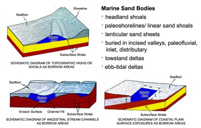 |
| Marine sand bodies, having diverse origins and evolutionary histories, can be buried or exposed on continental shelves and often have been greatly modified by marine processes associated with the Holocene transgression. Nearshore marine sand bodies of the types shown above may offer the best potential sources for high quality sand for beach nourishment. (Williams and others, 2003) |
Because of the increasing importance of offshore areas, comprehensive, up-to-date and integrated databases that can be used as sources for modern Geographic Information Systems (GIS) are needed to produce base maps displaying thematic information such as sea floor geology, sediment character and texture, sea floor roughness, and engineering properties. Digital geologic maps, based on unified national data sets and showing the sedimentary character of U.S. continental margins, are critical for scientists to better understand and interpret the geologic history and evolutionary processes of continental margins. These products are also useful to managers for protecting and managing coastal and marine environments (Poppe and others, 2005).
The USGS, in collaboration with other Federal agencies (Navy/Office of Naval Research (ONR), Minerals Management Service (MMS), U.S. Army Corps of Engineers (USACE), National Oceanic and Atmospheric Administration (NOAA)), state agencies, and universities, is leading a nationwide effort to gather legacy marine geologic data for use in conducting assessments of offshore sand and gravel resources and for producing GIS map products of sea floor geology that can serve many additional needs. Assessments are being conducted in offshore Louisiana, the New York Bight (New York-New Jersey) (Williams and others, 2006), and the Gulf of Maine regions. The GIS maps and usSEABED database from this study are providing fresh scientific insights into the geologic character and development of U.S. continental margins and useful information about the quality and potential availability of offshore sand and gravel aggregates. Additional details are available at: http://woodshole.er.usgs.gov/project-pages/aggregates/index.htm.
Back to Top
National Benthic Habitats Studies
The quality and protection of natural environments is a high priority for the Nation. This includes Federal lands in the coastal and marine realm where a variety of human activities stress natural systems and resources. The USGS is a lead scientific agency conducting research on the Atlantic, Gulf of Mexico, and Pacific margins to better understand marine sea floor environments. This research on benthic habitats is conducted under the general topic of “habitat geoscience,” which is defined as the study and classification of seabed habitats in the context of their geologic framework, their response to seabed processes, and their function as substrate for invertebrates and fish, is underway in all three regions. This research requires close collaboration between geologists, biologists, and oceanographers. High-resolution and detailed knowledge of bottom characteristics and sediment distribution, a goal of the usSEABED database, is fundamental to these studies.
Habitat research in the Gulf of Mexico is presently conducted within and offshore Tampa Bay and the Suwannee River Basin, Florida, in Mobile Bay , in the Texas-Louisiana Shelf, in Pulley Ridge, and in Flower Garden Banks National Marine Sanctuary in collaboration with many Federal and State agencies and academic institutions. Habitat studies are based on high-resolution sea floor imagery (bathymetry, backscatter) and groundtruth data (video and photo imagery, and geological and biological samples). These data sets are used to produce interpretive maps that show surficial and subsurface geology, habitats as classified into different ecologic types, the distribution of fauna and flora, and the effects of seabed processes.
Applications of research results include fishery management, habitat disturbance and recovery studies, impacts of invasive species, studies of deep-water coral habitats, the fates of contaminants from coastal sources, location and monitoring of disposal sites, the routes of cables and pipelines on the seabed, and the location of aggregate deposits having potential for use for beach nourishment. For more information on benthic habitat studies, see: http://marine.usgs.gov/, http://woodshole.er.usgs.gov/, and http://walrus.wr.usgs.gov/nearshorehab/.
|