 |
|
|
||||
| U.S. Geological Survey Data Series 344 |
Publications are available from USGS Information Services, Box 25286, Federal Center, Denver, CO 80225-0046 (telephone 1-888-ASK-USGS; email: infoservices@usgs.gov).
Contents:Information StatementGetting StartedSystem RequirementsProject SummaryCD OrganizationAcknowledgmentsReferences Cited |
|||
 |
|||
This CD-ROM publication was prepared by an agency of the U.S. Government. Although these data have been processed successfully on a computer system at the U.S. Geological Survey, no warranty expressed or implied is made regarding the display or utility of data on any other system, or for general or scientific purposes, nor shall the act of distribution imply any such warranty. The U.S. Geological Survey shall not be held liable for improper or incorrect use of the data described and (or) contained herein. Reference herein to any specific commercial product, process, or service by trade name, trademark, manufacturer, or otherwise does not constitute or imply its endorsement, recommendation, or favoring by the U.S. Government nor any agency thereof.
To access the information contained on this disc, open the index.html file with a Web browser. This report is divided into 15 sections; links at the top and bottom of each page provide access to these sections. This report contains links to the U.S. Geological Survey and collaborators or other resources that are only accessible if access to the Internet is available while viewing these documents.
This CD disc is readable on any computing platform that has standard CD-ROM driver software installed. The minimum software requirements are a Web browser, Adobe Reader, and a text editor. Please see the Software link for additional software requirements for use of processing software for interpreted core classification profiles and for links to free and trial software downloads.
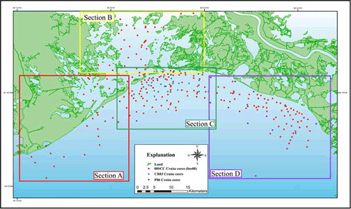
In 2000, the U.S. Geological Survey (USGS), in cooperation with the University of New Orleans (UNO) and the U.S. Army Corps of Engineers (USACE), conducted geologic surveys in Barataria Bight from Sandy Point to Belle Pass, LA (Study Area Map). Sediment cores were collected as part of the USGS Subsidence and Coastal Change (SCC) Project, which included the Barataria Sand-Resource Study (bss) vibracore surveys (Kindinger and others, 2001). This report also contains information from other cruise data sets, including the Cheniere Ronquille, LA, data (CR83) and the Plaquemines, LA, data (P86). The sediment data for these cruises were obtained by the Louisiana Geological Survey (LGS), the Louisiana Department of Natural Resources (LDNR), and Alpine Ocean Seismic Survey, Inc., as part of the near shore sand resource inventory of "Louisiana Sand Resource Inventory 1985 Vibracore Services" (Suter and others, 1991; Alpine Ocean Seismic Survey, Inc., 1986). Additionally, this report also includes the U.S. Army Corps of Engineers EUSTIS borehole cores (B-#). EUSTIS is the type of drill rig used to obtain the borehole cores and is used as name identifier for the USACE borehole cores presented herein. These cores are presented on a separate map with links to the description profiles and grain-size data that can be found by clicking on the USACE EUSTIS link.
This report serves as an archive of vibracore data collected during field activities of Subsidence and Coastal Change (SCC) 00SCC01, 00SCC03, 00SCC05 (collectively noted in the report as 00SCC) by the U.S. Geological Survey, CR83 (Cheniere Ronquille, LA) and P86 (Plaquemines, LA) by the Louisiana Geological Survey and the Louisiana Department of Natural Resources and borehole data collected in 2000 for the U.S. Army Core of Engineers (USACE-EUSTIS). Data presented here include the sections Vibracore Description Sheets, Interpreted Core Classification Profiles, Grain-Size and Penetrometer Data, core location Maps and Core Data Table of all core data analysis files, and vibracore Photographs. Additional data include Field Activity Collection System (FACS) logs and scanned observer's logbooks (Field Logs), as well as formal Federal Geographical Data Committee (FGDC) Metadata. Please refer to the Acronyms page for explanation of all acronyms and abbreviations used in this report. The data are in XLS, PDF, GIF, JPEG, and RTF formats and may be downloaded and processed with commercial or public domain software such as Microsoft Office or Text Editor (Software). PDF files may be viewed using Adobe Reader.
The USGS Florida Integrated Science Center (FISC) - Coastal and Watershed Studies in St. Petersburg, FL, assigns a unique identifier to each cruise or field activity. For example, 00SCC01 designates the year the data were collected (2000) for the Subsidence and Coastal Change (SCC) Project and the field activity number (01) for that project in that calendar year. Refer to http://walrus.wr.usgs.gov/infobank/programs/html/definition/activity.html for a detailed description of the method used to assign the cruise ID. For more information about the naming convention used, refer to the Metadata.
Sediment samples for cruises 00SCC, CR83, and P86 were collected using a vibracore system. This system is capable of collecting sediment cores in unconsolidated sediments with penetration to 20 feet (ft) in depth. The USACE EUSTIS borehole cores used a different method, one that uses a boring technique to penetrate deeper sand deposits. Detailed information on the vibracore, borehole core collection, and sediment core description processes and on measurement, sampling, and data analysis is found in the Methods section.
Note: All sediment core data are in the Core Data Table linked to the cores on the Study Area Map for all vibracores (00SCC, CR83, and P86) and the cores on the USACE EUSTIS map for all borehole cores. Clicking on a core or core ID on the Study Area Map pages will bring forth a table that contains all sediment core data and displays the specific core information. The back button returns the user to the Study Area Map section. The sediment table (includes data from all cruises: USACE EUSTIS borehole cores (B-#), 00SCC (bss cores), CR83, and P86) contains core ID and five other columns containing previews and downloadable files for vibracore description sheets, interpreted core classification profiles, grain-size data, penetrometer data, and photographs.
A list of missing data for each cruise is as follows.
Some vibracores have differences in naming schemes; please see the Metadata for clarification on cruise ID and core ID naming schemes and identification codes. Detailed information about the each cruise can be found in the digital FACS field and equipment logs. Please refer to the Methods page for detailed descriptions on each type of sediment data analysis. Also, information on the digitizing process for interpreted core classification profiles can be found in Flocks this volume (see Software page). Step-by-step instructions on the process can be obtained from the FISC. Contact James Flocks (jflocks@usgs.gov) for more information.
The Disc Contents page is a diagram of the location of all files and folders contained on this disc and provides links to these files and folders. This disc contains the Readme file, HTML files, and all folders, images, and data linked to the HTML pages. See Getting Started or the Disc Contents page for the full description.
The USGS Coastal and Marine Geology Program and the University of New Orleans provided funding and (or) support for this study. The U.S. Army Corps of Engineers (USACE), the Louisiana Geological Survey (LGS), the Louisiana Department of Natural Resources (LDNR), and Alpine Ocean Seismic Survey, Inc., for conducted geophysical surveys, sediment data, and publication of these cruises archived in this report. We thank R/V G.K. Gilbert captains Dave Bennett of Eckerd College and Rich Young of the USGS in St. Petersburg, FL, for their assistance in data collection. This document was improved by the reviews of Shawn Dadisman (USGS) and Arnell Harrison (Jacobs Technology Inc.) at the FISC in St. Petersburg, FL.
Alpine Ocean Seismic Survey, Inc., 1986, Final Report: Louisiana Sand Resource Inventory 1985 Vibracore Services, report prepared for Department of Natural Resources State of Louisiana, Contract No. 21940-86-01, ORC Contract No. 431-6006, amendment ORC Contract No. 431-6006A: Norwood, NJ, 11 p.
Flocks, J.G., this volume, Directions for converting analog sediment core description sheets to digital spreadsheet format, text accompanying (available in Programs Data directory): Excel macro digitizing program, 16 p.
Flocks, J., 2004, Converting analog interpretative data to digital formats for use in database and GIS applications: USGS Open File Report, 2004-1070.
Folk, R.L., 1968, Petrology of sedimentary rocks: Austin, TX, University of Texas Press, 167 p.
Hobson, R.D., 1979, Definition and use of the phi grade scale: U.S. Army Corp of Engineers Coastal Engineering Research Center, Coastal Engineering Technical Aid No. 79-7 18 p.
Inman, D.L., 1952, Measures for describing the size distribution of sediments: Journal of Sedimentary Petrology, v. 22, No. 3, p. 175-188.
Kindinger, Jack, Flocks, J.G., Kulp, Mark, and Penland, Shea, 2001, Sand resources, regional geology, and coastal processes for the restoration of the Barataria Barrier shoreline: U.S. Geological Survey Open-File Report 01-384, 69 p.
Krumbein, W.C., 1938, Size frequency distribution of sediments and the phi normal curve: Journal of Sedimentary Petrology, v. 18, p.84-90.
Suter, J.R., Penland, Shea, and Ramsey, K.E., 1991, Nearshore sand resources of the Mississippi River Delta Plain: Marsh Island to Sandy Point: Coastal Geology Technical Report No. 8, Louisiana Geological Survey, Baton Rouge, LA, Appendix B. p.119-120.
Wentworth, C.K., 1922, A scale of grade and class terms for clastic sediments: Journal of Geology, v. 30, p.377-392.
USACE, 1977, Shore protection manual (3rd edition): Vicksburg, MS, U.S. Army Corp of Engineers, Coastal Engineering Research Center, v. II, p.1-59.