 |
|
|
||||
| U.S. Geological Survey Data Series 344 |
|
Information defining the vibracore description sheet profiles and explaining how the data were obtained and processed is available in the Methods section under Core Description Sheets.
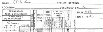
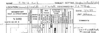
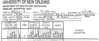
For each cruise a paper copy of each vibracore description sheet was scanned and converted into a PDF document (image-only) that can be accessed using Adobe Adobe Reader. The format of the description sheets varies. However, all description sheets contain similar information such as the core ID, location, water depth, sedimentary setting, and so on. The following figure depicts the three types of description sheets found within this report. Cruise CR83
Cruise P86
Cruise 00SCC
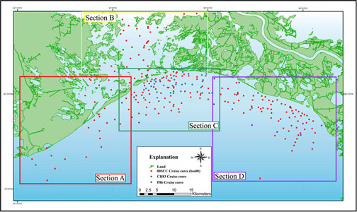
Accessing the Data To access the data for each core simply click on the Study Area Map (right) and then navigate to the section that contains the desired core. Right-click (to open page in a new window) on a core or core label to activate a table that contains links to specific data sets for each core. The vibracore description sheet data for each cruise are presented in the data table on the Core Data Table page. The table contains a column entitled Core Description Sheets that contains each cores thumbnail preview and links to PDF files. Note: If unable to access the Vibracore Description Sheets in PDF format, the Interpreted Core Classification Profiles are digitized versions of 00SCC (bss00_#), CR83, and P86 vibracore description sheets and are accessible as XLS files on the Core Data Table, or please contact cdreher@usgs.gov. PDF files may be viewed using Adobe Reader software. Information on PDF accessibility may be viewed at Adobe-Accessibility Resource Center. |
Click on the Study Area Map above to open an enlarged map version. The enlarged map contains core locations that are linked to Vibracore Description Sheets, Interpreted Core Classification Profiles, Photographs, and Grain-Size and Penetrometer Data. |


![]() U.S. Department of the Interior |
U.S. Geological Survey
U.S. Department of the Interior |
U.S. Geological Survey
URL: https://pubsdata.usgs.gov/pubs/ds/344/html/vibraprofiles.html
Page Contact Information: Publications Team
Page Last Modified: Monday, 28-Nov-2016 13:01:21 EST