Selected Water- and Sediment-Quality, Aquatic Biology, and Mine-Waste Data from the Ely Copper Mine Superfund Site, Vershire, VT, 1998–2007
Data Series 378
Prepared in cooperation with the U.S. Environmental Protection Agency
By Denise M. Argue, Richard G. Kiah, Nadine M. Piatak, Robert R. Seal II, Jane M. Hammarstrom, Edward Hathaway, and James F. Coles
Introduction
The data contained in this report are a compilation of selected water- and sediment-quality, aquatic biology, and mine-waste data collected at the Ely Copper Mine Superfund site in Vershire, VT, from August 1998 through May 2007. The Ely Copper Mine Superfund site is in eastern, central Vermont (fig. 1) within the Vermont Copper Belt (Hammarstrom and others, 2001). The Ely Copper Mine site was placed on the U.S. Environmental Protection Agency (USEPA) National Priorities List in 2001. Previous investigations conducted at the site documented that the mine is contributing metals and highly acidic waters to local streams (Hammarstrom and others, 2001; Holmes and others, 2002; Piatak and others, 2003, 2004, and 2006). The U.S. Geological Survey (USGS), in cooperation with the USEPA, compiled selected data from previous investigations into uniform datasets that will be used to help characterize the extent of contamination at the mine. The data may be used to determine the magnitude of biological impacts from the contamination and in the development of remediation activities.
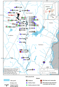
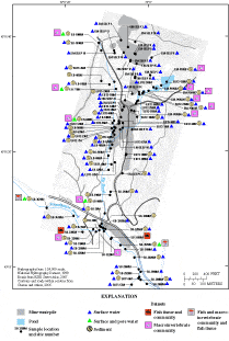
This report contains analytical data for samples collected from 98 stream locations, 6 pond locations, 21 surface-water seeps, and 29 mine-waste locations. The 98 stream locations are within 3 streams and their tributaries. Ely Brook flows directly through the Ely Copper Mine then into Schoolhouse Brook (fig. 2), which joins the Ompompanoosuc River (fig. 1). The six pond locations are along Ely Brook Tributary 2 (fig. 2). The surface-water seeps and mine-waste locations are near the headwaters of Ely Brook (fig. 2 and fig. 3). The datasets "Site_Directory" and "Coordinates" contain specific information about each of the sample locations including stream name, number of meters from the mouth of stream, geographic coordinates, types of samples collected (matrix of sample), and the figure on which the sample location is depicted.
Data have been collected at the Ely Copper Mine Superfund site by the USEPA, the Vermont Department of Environmental Conservation (VTDEC), and the USGS. Data also have been collected on behalf of USEPA by the following agencies: Arthur D. Little Incorporated (ADL), U.S. Army Cold Region Research and Engineering Laboratory (CRREL), URS Corporation (URS), USEPA, and USGS. These data provide information about the aquatic communities and their habitats, including chemical analyses of surface water, pore water, sediments, and fish tissue; assessments of macroinvertebrate and fish assemblages; physical characteristics of sediments; and chemical analyses of soil and soil leachate collected in and around the piles of mine waste.