
|
|
|
|
|
Introduction
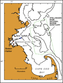
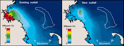
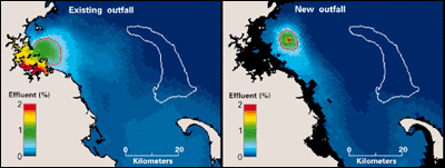
Computer simulations conducted by the U.S. Geological Survey (USGS) of sewage effluent dilution indicate that, while elevated effluent levels will be found within a few kilometers of the new outfall, effluent levels will remain low throughout most of Massachusetts Bay and will dramatically decrease in Boston Harbor. The new outfall site in western Massachusetts Bay has the important advantage of being in deeper water. This location allows greater dilution of effluent when compared with that in the shallow, confined waters of Boston Harbor. As a result, the areal extent of relatively high effluent levels will be reduced.
Simulation ModelsIn recent years, there has been significant progress in the development of numerical circulation models that are able to simulate and predict the transport processes that operate in coastal areas. Such models, when properly configured and validated with observational data, are often the best tool for evaluating management scenarios in the coastal ocean. Because of the complexity of driving forces and topography in Boston Harbor and Massachusetts Bay, computer models have played a critical role in predicting how sewage effluent released from the new outfall will be transported and diluted. The Estuarine and Coastal Ocean Model (ECOM) was used to study the new Massachusetts Bay outfall site; this model was originally developed by George Mellor and Alan Blumberg at Princeton University and has been further refined by the oceanographic community over the past 10 years. It has been used in more than 40 studies in coastal waters worldwide. The model simulates currents and water properties in three dimensions (and time), driven by wind, river runoff, offshore discharges of freshwater, surface heating and cooling, tides, and sea-level fluctuations in the open ocean. In Massachusetts Bay, the model has been used to study the flushing characteristics of Boston Harbor, to provide input for a baywide water-quality model, and to assess the impact of possible chlorination failure at the new outfall location, as well as to predict effluent dilution. In studies by the USGS, the ECOM model was configured to encompass all of Massachusetts and Cape Cod Bays, with a resolution that varied from approximately 1 km in western Massachusetts Bay to about 6 km in the open ocean outside Massachusetts Bay. Simulations were performed over an 18-month period from January 1990 to July 1991, a time of particularly intense oceanographic data collection by the Massachusetts Bays Estuary Program, a program funded by the U.S. Environmental Protection Agency. Utility of the ECOM ModelComparing the model to the observational data gathered showed that the model reproduced the development of seasonal stratification in the bay and the statistics for currents responsible for effluent transport in western Massachusetts Bay. The model was therefore judged to be appropriate for use in simulating effluent fields produced by continuous discharge in this region. Comparative dilution simulations for the existing outfalls and for the new outfall (figs. 2 and 3) projected that effluent concentrations in Boston Harbor will be greatly reduced by using the new outfall site, without significantly increasing concentrations in most of Massachusetts Bay. Thus, the model simulations supported the use of the new outfall.
The FutureWhile these effluent-concentration simulations are encouraging, dilution alone will not solve the pollution problem in this area. Although dilution can decrease the impact of pollutant effects in the water column, pollutants that settle into the sediments can accumulate in the ecosystem, and for some contaminants, source reduction is the only viable long-term solution. For this reason, the ocean outfall site will be complemented by a new secondary sewage treatment plant that will greatly reduce the levels of solid sewage and toxic substances entering the ecosystem. Models provide our best estimate of what will happen, but they are based on projections, not certainties. Unforeseen events such as pipeline leaks or the failure of chlorination at the new location can occur. In the baywide monitoring program currently underway in Massachusetts Bay, trigger levels have been set and contingency plans developed to ensure that such events will be detected and corrective action taken, once the new outfall is activated.
|
Related Publications:
The Legacy of Contaminated Sediments in Boston Harbor
- USGS Fact Sheet Contaminant Accumulation in the Boston Harbor-Massachusetts Bay Sedimentary System - USGS Fact Sheet 172-97 Turning Point in Boston Harbor Clean-Up Contaminated-Sediment Database Development and Assessment in Boston Harbor - USGS Fact Sheet 78-99 Related Links: Stellwagen Bank National Marine Sanctuary Massachusetts Bays National Estuary Program
Environmental Protection Agency Massachusetts Water Resources Authority |