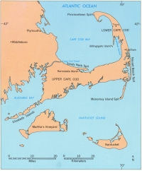
Cape Cod is a sandy peninsula built mostly during the ice age and juts into the Atlantic Ocean like a crooked arm (see Fig. 1 above). Geologists are interested in Cape Cod because it was formed, by glaciers, very recently in terms of geologic time and because of the ever changing shore as the Cape adjusts to the rising sea.
by Robert N. Oldale U.S. Geologic Survey, Woods Hole Field Center, Massachusetts
--DISCLAIMER--
This report is preliminary and has not been reviewed for
conformity
with U.S. Geological Survey editorial standards or with the North
American Stratigraphic Code. The use of trade, product, or
industry names in this report is
for descriptive or location purposes only and does not constitute
endorsement
of products by the U.S. Government. Opinions and conclusions
expressed herein do not necessarily
represent those of the USGS.
Web Page by
Donna Newman
[an error occurred while processing this directive]