Introduction
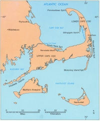
Because of its exposed location, Cape Cod was visited by many early explorers. Although clear-cut evidence is lacking, the Vikings may have sighted this land about 1,000 years ago. It was visited by Samuel de Champlain in 1605, and his detailed descriptions and charts have helped present-day scientists to determine the rate of change of Nauset Beach Spit and Nauset marsh. Bartholomew Gosnold, a lesser known explorer, settle for a short time on the Elizabeth Islands to the southwest of Woods Hole and gave Cape Cod its name in 1602.
The Pilgrims first landed in America on the tip of lower Cape Cod after they were turned back from their more southerly destination by shoals between Cape Cod and Nantucket Island. On Cape Cod, they found potable water and food and had their first fight with the natives. The Pilgrims, however, decided that this land was too sandy to support them, and they sailed across Cape Cod Bay to establish Plymouth. Today, the natural landscape of Cape Cod is little changed. Small villages are separated by large areas of forest, dune, beach, and marsh. This unspoiled natural beauty makes Cape Cod one of the most favored vacation areas for the people living in the thickly settled northeastern States.
The Great Ice Age (called the Pleistocene Epoch) began about one and a half million years ago. It is characterized by great ice sheets that advanced into the temperate regions of the Earth many times. These events are called glacial stages. Each glacial stage was accompanied by a worldwide lowering of sea level, because the glacial ice was made from water evaporated from the ocean basins. When these continental ice sheets melted away, during interglacial stages, the climate and sea level were probably much like they are today. In fact, many scientists believe that the Earth is presently in an interglacial stage and that ice sheets will once again advance into the temperate regions of the globe. If previous interglacial stages are used as an example, it suggests that the present interglacial is near its end and a new ice age is about to begin. However, man-induced global warming may alter this somewhat.
As the last continental ice sheets melted away, the water returned to the ocean basins and sea level rose. Eventually, on Cape Cod, the rising sea began to drown the land left behind by the ice. Waves attacked the shore and eroded the glacial deposits. The sand was transported and redeposited by waves and currents to form bays protected from the open ocean by barrier spits and barrier islands. In the bays, marshes grew as the sea rose. The remaining glacial landforms and the landforms created by the rise in sea level make up today's landscape.
|
Web Page by
Donna Newman
[an error occurred while processing this directive] |
|