Cape Cod and the Sea
During the Laurentide glaciation and for some time after the retreat of the ice away from Cape Cod, worldwide sea level was about 400 feet below its present level. Much of the continental shelf to the south of Cape Cod (Fig. 18) was dry land, as was Georges Bank to the east and Stellwagen Bank to the north. However, the sea was never far away from the lower Cape following the retreat of the ice, because, as the ice retreated away from Cape Cod and into the Gulf of Maine, it was immediately replaced by sea water.
|
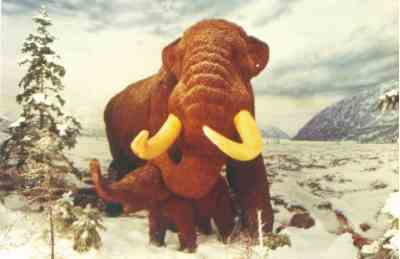
| Figure 19. Many of the plants and animals that live on Cape Cod today as well as extinct animals such as mastodon and mammoth survived the ice ages by occupying the emerged Continental Shelf south of the ice front as well as ice free regions throughout North America south of the glacial limit. This mastodon and calf are part of a life-size diorama at the New York State Museum in Albany. Photograph supplied by Robert H. Fakundiny. |
This occurred because of deep basins in the Gulf of Maine, which are close to the lower Cape and because the weight of the glacial ice had depressed the crust in the Gulf of Maine to below the world wide low sea level. Thus, the lower Cape Cod has had a maritime environment since about 19,000 years ago.
Mastodon, mammoth, (Fig. 19)
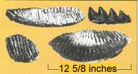
and other extinct animals of the Pleistocene Epoch, and most, if not all, of the animals and plants that now live in northeastern North America, survived the Laurentide glaciation on the exposed continental shelf. Evidence for the presence of mastodon and mammoth is provided by the numerous teeth dredged from the sea floor of the continental shelf and the Gulf of Maine (Fig. 20).
Click on each figure or figure number below to see larger image
Figure 20. Mastodon and mammoth teeth dredged from submerged continental shelf provide evidence that these animals lived south of Laurentide ice sheet. These teeth came from Gulf of Maine north of Cape Cod indicating that these and other animals migrated northward as the ice sheet retreated. |
|
|
Early people called Paleoindians may have lived on the exposed shelf about 11,000 years ago. Both plants and animals migrated northward as the ice retreated and as the rising sea level inundated the continental shelf.
As the continental ice sheets melted around the globe and the water returned to the ocean basins, sea level rose. At first the sea rose quickly, about 50 feet in 1,000 years. As glacial ice volumes became reduced, the rise in sea level gradually slowed. On Cape Cod, the rate of sea-level rise between 6,000 years ago and 2,000 years ago was about 11 feet per 1,000 years. From 2,000 years ago, the rate of sea-level rise was about three feet per 1,000 year. Rates of worldwide sea-level rise were determined using radiometric ages of submerged shoreline features. Local rates of sea-level rise have been determined by radiocarbon dating of salt-marsh peats that are an accurate indicator of sea level.
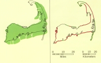
By about 6,000 years ago, the rising sea reached the cape and wave erosion of the glacial deposits began. At first, headlands composed of glacial drift, east of the present eastern shore of the Cape, began to erode as waves attacked the fragile land to form marine scarps or sea cliffs. The sea, however, does not simply destroy the land (Fig. 21).
|
|
Figure 21. About 6,000 years ago, before extensive wave erosion of the glacial deposits had occurred, the glacial Cape probably resembled the map on left. The present pattern of erosion is shown on the map on right. (Click for further explanation.) |
|
Much of the eroded material is reworked and transported along the shore by longshore drift and longshore currents generated by the oblique approach of the waves. This transported material is redeposited along the shore to form new land. The sand is transported and redeposited to form bay mouth bars, spits, and barrier islands across embayments in the coastline (Fig. 21).
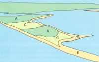
Figure 22. Wellfleet Harbor occupies a depression that was formed when ice, possibly a sublobe of the South Channel lobe, prevented outwash deposition.
(Click for explanation) |
|
|
At this time, the coastline may have resembled the present coastline from Eastham southward (Fig. 15). These features were the forerunners of the present Provincetown spit and the barrier islands of Eastham, Orleans, and Chatham. In Cape Cod Bay, wave erosion of headlands and formation of the spits, including the spits called tombolos that connect the Wellfleet Harbor Islands (Fig. 22)and protect the harbor from the open ocean, probably started somewhat later.
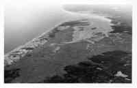
Figure 23. Aerial view of Sandy Neck barrier beach and the Great Marshes at Barnstable. The barrier was built by wave-generated longshore drift, longshore currents carrying sand derived from the cliffed glacial deposits to the west, and onshore winds carrying sand inland to form the sand dunes about 4,000 years ago as the rising sea drowned the glacial cape (photo by Dann Blackwood). |
|
|
|
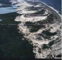
| Figure 24. Air photo of parabolic (U-shaped) dunes on Provincetown Spit. The view is from west to east. Prevailing westerly winds have blown out the centers of the dunes so that they open to the west.
|
Sandy Neck (Fig. 23)is thought to have formed around 4,000 years ago when relative sea level stood a little more than twenty feet below present.
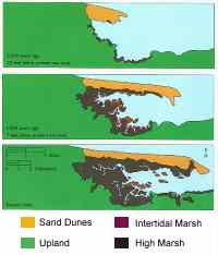
Many spits shelter a quiet body of water called a lagoon. Associated with the lagoon are salt marshes and sand or mud flats. The spits also form the foundation for coastal sand dunes, the best examples of which occur in the Provincetown and Truro area (Fig. 24)and on Sandy Neck. The combination of spit, lagoon, salt marsh, and sand dune make up what is called a barrier island. "Barrier Island" is a generic term that also includes barriers tied to headlands. The growth and development of these features as well as the lagoon are closely related to the growth of the protecting spit. For example, Sandy Neck in Barnstable has grown during the past 3,000 years from a spit a little over 1 mile long protecting a small lagoon and a few patches of marsh to a barrier island 6 miles long protecting a large lagoon and a marsh of several square miles (Fig. 25).
|
| Figure 25. Stages in development of Sandy Neck spit and the Great Marshes west of Barnstable from 3,000 years ago to present time. The marsh grew upward in response to the rising sea and laterally in response to the growth of the spit. The maps, ages, and relative sea level (photo from A. C. Redfield). |
Once formed, spits and barrier islands do not remain unchanged for long.
The forces of waves and wind continue to transport and redeposit the beach and dune deposits. The eroded material carried by the waves and currents is washed into the lagoon during northeast storms and hurricanes to form a new foundation for the dunes. In this manner, the barrier islands migrate landward. Without this landward migration, in response to the rising sea level, the spits and barrier islands would drown. Strong onshore winds also transport sand inland where it is deposited to form dunes. On young spits, the dunes are usually small, but on mature barrier islands, such as Sandy Neck, Monomoy Island, and Provincetown, the dunes reach heights of 40 to 100 feet. The dunes themselves are attacked by the wind and, where unprotected by vegetation, continuously change shape. For example, the parabolic dunes in Provincetown and Truro (Fig. 24) are formed when the prevailing west wind blows out the middle of an existing dune. In the past, the dunes were covered by mature forest and were stable. A remnant of this cover, the beech forest, can be seen in Provincetown. Unfortunately, sand transported from adjacent unstable dune areas is slowly burying the forest. Elsewhere, evidence of past forest cover is the forest floor layers exposed by the wind in the unstable dunes. On sandy Neck, flint chips, charcoal, and hearth stones from Indian encampments are associated with some of the exposed forest floor layers.
Web Page by
Donna Newman
[an error occurred while processing this directive] |
|