
|
|||||


National Assessment of Coastal Vulnerability to Sea-Level Rise: Preliminary Results for the U.S. Pacific CoastU.S. Geological Survey Open-File Report 00-178E. Robert Thieler and Erika S. Hammar-Klose
|
 Click on figure for larger view. |
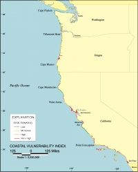
Figure 1. Map of the Coastal Vulnerability Index (C.V.I.) for the U.S. Pacific coast. The C.V.I. shows the relative vulnerability of the coast to changes due to future rise in sea-level. Areas along the coast are assigned a ranking from low to very high risk, based on an analysis of physical variables that contribute to coastal change.
One of the most important applied problems in coastal geology today is determining the physical response of the coastline to sea-level rise. Predicting shoreline retreat, beach loss, cliff retreat, and land loss rates is critical to planning coastal zone management strategies and assessing biological impacts due to habitat change or destruction. Presently, long-term (>50 years) coastal planning and decision-making has been done piecemeal, if at all, for the nation's shoreline (National Research Council, 1990; 1995). Consequently, facilities are being located and entire communities are being developed without adequate consideration of the potential costs of protecting or relocating them from sea-level rise related erosion, flooding and storm damage.
| |
Contents | Back to Top | Next Page |
| Introduction | Risk Variables |
Data Ranking |
C.V.I. | Results | Discussion | Summary | References |
Acknowledgments |
This report is preliminary and has not been reviewed for conformity with U.S. Geological Survey editorial standards or with the North American Stratigraphic Code. Any use of trade, product, or firm names in this publication is for descriptive purposes only and does not imply endorsement by the U.S. Government. |
|
Contact
Rob Thieler |