National Assessment of Coastal Vulnerability to Sea-Level Rise: Preliminary Results for the U.S. Pacific Coast
Results
The calculated C.V.I. values range from 2.0 to 28.3. The mean C.V.I. value is 9.92; the mode is 7.74; and the median is 8.48. The standard deviation is 5.45. The 25th, 50th, and 75th percentiles are 5.54, 8.54, and 12.52, respectively.
Figure 1 shows a map of the coastal vulnerability index for the U.S. Pacific Coast. The C.V.I. scores are divided into low, moderate, high, and very high-risk categories based on the quartile ranges and visual inspection of the data. C.V.I. values below 5.5 are assigned to the low risk category. Values from 5.5-8.5 are considered moderate risk. High-risk values lie between 8.5-12.5. C.V.I. values above 12.5 are classified as very high risk. Histograms of the C.V.I. values are shown in Figure 2.
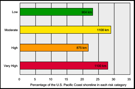 |
Figure 3. Bar graph showing the percentage of shoreline along the U.S. Gulf of Mexico coast in each risk category. |
Figure 3 shows a bar graph of the percentage of U.S. Pacific shoreline in each risk category. A total of 3987 km of shoreline is evaluated in the study area. Of this total, 27 percent of the mapped shoreline is classified as being at very high risk due to future sea-level rise. Twenty-two percent is classified as high risk, 28 percent as moderate risk, and 23 percent as low risk.
In the calculation of the Coastal Vulnerability Index, certain variables add more weight to the index than others. For example, in a region where most variables score low in the risk ranking (1-3), but one variable scores high (4 or 5), the high variable adds the most weight to the index. This variable is said to dominate the index. In most cases along the U.S. Pacific Coast, one or two variables dominate the index, whereas the other lower ranking variables have little impact on the index value.
The mapped C.V.I. values show numerous areas of very high vulnerability, particularly in the San Francisco - Monterey Bay area and in southern California from San Luis Obispo to San Diego, where the coast is most highly populated. The highest vulnerability areas are typically lower-lying beach areas; their susceptibility is primarily a function of geomorphology and coastal slope. On the northern Pacific coast, wave energy is a dominant variable (adds weight to the index), whereas to the south, tides and relative sea-level dominate the index. In general, the C.V.I. values for Washington, Oregon and northern California are defined by variable geomorphology over small spatial scales (~ 10 km). Rocky headlands and cliffs with sandy pocket beaches characterize this coastline, with only a few long stretches of sandy beach. In contrast, the southern coast of California has long stretches of both rocky cliffs and sandy beaches, where geomorphology typically varies at a longer length scale (from 50 to 100 km).
The low risk, least vulnerable areas generally occur at rocky headlands along cliffed coasts where the coastal slope is steep, relative sea-level is falling, tide range is large and wave energy is lower. Examples of these areas are the northern coast of Washington, Monterey, California and Cape Mendocino, California (Figure 1).
|