Disposal
Activity in the HARS between November
1996 and April 2000
Between
November 1996 and April 2000 dredge and capping material consisting of a heterogeneous
mix of sediment types were placed in the MDS and within the Primary Remediation
Area of the HARS. Based on records from the U.S.
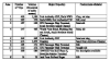
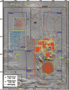
Army Corps of Engineers, disposal was clustered in eight areas (Figure
2, Table 1). For material placed in areas 1-6,
the plotted locations are the position of the tug towing the scow when disposal
began, not the position of the scow carrying the material; thus the actual location
of the material on the sea floor may differ from this position by several hundred
meters. For the material placed in Areas 6, 7 and 8 between November 1998 and
April 2000, the placement location was determined by an automated tracking system
installed on the scow (SAIC, 1998). The plotted locations indicate the position
of the scow when placement began. Areas 1- 4, located within the MDS, received
dredged material from various projects prior to closing of the MDS and designation
of the HARS (Table 1). Area 5, located in the southeastern
corner of the MDS, received approximately 660,000 cubic yards of Category II
fine-grained material dredged from three berthing areas within the Harbor (Category
II sediments have no significant toxicity but a potential for bioaccumulation;
they are suitable for restricted ocean disposal with appropriate management
practices such as capping (EPA, 1996)). This material was covered with a minimum
of one meter of sand (approximately 2.4 million cubic yards or 1.83 million
cubic meters) dredged from the Ambrose entrance channel to New York harbor.
This sand was slowly released from scows and/or hopper dredges along ship tracks
oriented north to south (see Figure 2). Capping was
completed in February 1998. As of November 1998, when the second multibeam survey
was carried out, Category I capping material (silt and clay with a high water
content) from dredging of the Passenger Ship Terminal, located on the Hudson
River on the west side of Manhattan, had been placed within PRA#1 (Area 6).
Between November 1998 and April 2000, additional material was placed in PRA#1
(Area 6), PRA#2 (Area 7), and PRA#3 (Area 8).
|
|