|
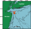
Data Collection and ProcessingThe surveys were conducted using a Simrad EM 1000 multibeam echo sounder mounted aboard the Canadian Hydrographic Service vessel Frederick G. Creed, a 60 foot SWATH (Small WAterplane Twin Hull) ship. This multibeam system, mounted on the starboard pontoon of the Creed, utilizes 60 electronically aimed beams spaced at intervals of 2.5° that insonify a strip of sea floor up to 7.5 times the water depth (swath width of 100 to 200 meters within the survey area). The horizontal resolution of the beam on the sea floor is approximately 10% of the water depth (3-5 meters in the survey region). Vertical resolution is approximately 1 percent of the water depth, or 0.3 meters. The data presented were gridded at 3 meters grid cell size. Software developed by the Ocean Mapping Group, University of New Brunswick (http://www.omg.unb.ca/), was used to process and edit the topographic, backscatter, and navigation data (see World Wide Web http://www.omg.unb.ca/~jhc/SwathEd.html). The Mercator maps use a latitude of true scale at 40° N. and central meridian of -75° W., and are projected on the WGS84 ellipsoid. The vertical datum is mean lower low water and depths in this report are presented as positive numbers. The measured elevations were adjusted for fluctuations in sea level during the survey by subtracting tidal elevations predicted by a tidal model and low-frequency sea level observed at the National Oceanic and Atmospheric Administration Sandy Hook tide station located at 40°28' N., 74°0.6' W. (Figure 1). The tidal model utilized 9 constituents (Table 2) derived from a 4-month bottom pressure record obtained at Station A, located at 40°23.4' N., 73°47.1' W. in 38 meters water depth about 2.7 km east of the HARS, during the winter of 1999-2000. Analysis of output from the ADCIRC tidal model (Westerink and others 1994; Luettich and Westerink, 1995) of the east coast showed that the tides throughout the HARS are less than 2 degrees of phase and 2 cm of amplitude different from Station A. Thus, a spatially uniform tidal sea level correction is applicable over the HARS. The difference between low-passed elevation at Sandy Hook and at Station A for the 4-month observation period was a few cm; thus the low-frequency sea level at Sandy Hook is a good proxy for the non-tidal changes in sea level that have large spatial scales and that occur at periods of a few days and longer. The difference between observed Station A elevations and simulated Station A elevations (Station A tidal predictions plus Sandy Hook low-frequency elevation) for the period December 12, 1999 to April 16, 2000 was normally distributed with a standard deviation of 3 cm. Thus, an estimate of the error due to sea level remaining in the multibeam observations after the sea level correction is about 3 cm. The estimated error in using Sandy Hook elevations alone for adjusting the measured elevations is 14 cm. Bathymetric data were contoured using ARC/INFO geographic information system software (Environmental Systems Research Institute, Inc.(http://www.esri.com), version 7.2.1). The processed data were formatted into a point coverage using the ARC/INFO "generate" routine. The point coverage was transformed to a Mercator projection having the longitude of the central meridian at 75º W. and the latitude of true scale at 40º N. The "pointgrid" routine was used to assign depth values to a grid with a cell size of 12 meters. Smoothing of the data was accomplished using a 12-cell by 12-cell (144 meters by 144 meters) median filter with the "focalmedian" routine. Topographic contours at a 1-meter interval were generated from the grid using the "latticecontour" routine. Samples
of the bottom sediments were obtained in the HARS by means of a modified Van
Veen grab sampler or a hydrostatically damped gravity corer on USGS cruises
DLW93009, SEAX95007, SEAX96004, and ALPH9820, carried out in May 1993, May 1995, May 1996,
and September 1998, respectively. Sediment was obtained from the upper 2 cm of grab samples
and analyzed using the methods described in Poppe and Polloni, 2001 (https://pubs.usgs.gov/openfile/of00-358/) Percentages
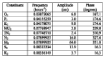
of gravel, sand, silt and clay are presented in Table 3. Samples obtained in
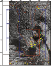
1993-1996 are shown on the 1996 map (Figure 5b);
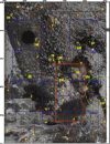
samples obtained in 1998 are shown on the 1998 map (Figure
6b). |
| |||||||||||||||
 Download Adobe Acrobat Reader at http://www.adobe.com/support/downloads/main.html. [an error occurred while processing this directive] |
|||||||||||||||||