Surficial Geology and Distribution of Post-Impoundment Sediment in Las Vegas Bay, Lake Mead
Methods
A sidescan sonar and high-resolution seismic-reflection survey was completed during May 30-June 9, 2000. The results of a coring program completed during July 11-18, 2000 will be summarized elsewhere. Sidescan sonar imagery and seismic-reflection data collected in 1999 (Twichell and others, 1999) were combined with the data collected in 2000 to provide more complete coverage of the study area. Data processing techniques differed somewhat between the two surveys, and here we summarize only the techniques used during the 2000 survey. Processing techniques for the 1999 survey are presented in Twichell and others (1999).
Click on each figure for larger image with caption.
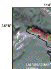
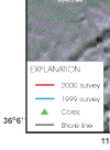
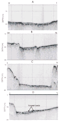
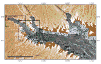
Figure 2. Survey track lines along which sidescan sonar and subbottom seismic-reflection profiles were collected. Red lines are tracks along which data were collected in 2000 and cyan lines are tracks run in 1999. Core locations are shown by black triangles. Yellow lettered lines are locations of profiles shown in Figure 13.
Geophysical data were collected along approximately 77 km of survey track lines (Fig. 2). In the shallow part of the lake off Las Vegas Wash track lines were run on a 25-100 m grid. Off Gypsum Wash a grid of lines was collected with 200 m spacing, and off Government Wash only a set of north-south trending lines was collected. The lines were spaced such as to provide complete sidescan sonar coverage of the lake floor off the three washes. The close spacing of the seismic lines allowed detailed mapping of the thickness and distribution of post-impoundment sediment. This survey extended far enough into the lake to overlap with the data collected by Twichell and others (1999).
The survey was conducted aboard an 8-m pontoon boat using an Edgetech DF-10001 sidescan sonar and a Knudsen1 Chirp subbottom profiling system. The central frequency of the sound source for the subbottom system was 3.5 kHz, and the data were logged digitally. The sidescan imagery was logged using an ISIS1 digital acquisition system developed by Triton-Elics Industries1. While both data types were collected on all track lines in water depths less than 40 m, only chirp subbottom profiles were collected along the few track lines in deeper water depths. Single-beam bathymetry was collected along all the survey track lines using a Garmin1 fathometer. Navigation was done with a P-Code GPS receiver with an estimated accuracy of +/- 10 m. Lake elevation during the survey was 368 m (1207 ft) (U.S. Bureau of Reclamation website:
http://www.lc.usbr.gov/~g4000/mead-elv.html).
During the field operation, the sidescan sonar data were processed and a digital mosaic was completed. The sidescan imagery was demultiplexed, corrected for slant-range distortions and signal attenuation using techniques summarized by Danforth and others (1991). The strips of image data were then mapped into their proper geographic location using software described by Paskevich (1996). Once the individual strips were mapped, they were combined into a composite digital mosaic using a remote sensing software package developed by PCI (Anonymous, 1992). The techniques for generating the composite digital sidescan mosaic are summarized by Paskevich (1992). The completed mosaic has a pixel size of 1 m. The image is in UTM projection, zone 11, using the WGS-84 ellipsoid.
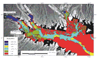
The sidescan sonar data sets from 1999 and 2000 were processed and mapped separately. The sidescan sonar mosaic was imported into ESRI's ArcView GIS package so that the data could be viewed in conjunction with the imagery collected in 1999. The combined 1999 and 2000 sidescan images are shown in Figure 3 and the interpretation of this imagery is shown in Figure 4. Where the two data sets overlapped, common features were within 15-20 m of each other. On the sidescan images presented in this report, a strong acoustic return, also referred to as high backscatter, appears as white and light gray tones. A weak acoustic return, low backscatter, is black or dark gray.
A Knudsen Chirp subbottom system was used during the 2000 survey. In the field, the seismic processing package, SEISMIC UNIX (Cohen and Stockwell, 1997) was used to create a PostScript file for each seismic profile. After the cruise, further processing was required on the seismic-reflection profiles using the seismic processing package SIOSEIS (http://sioseis.ucsd.edu) primarily to rectify of the data and convert it to "true" Chirp data containing just the instantaneous amplitude data.
Once all adjustments to the SEG-Y data were completed with SIOSEIS, these data were loaded into Seisworks (Landmark Graphics Corp) for digitizing interpretations. The sidescan sonar mosaic was displayed as a backdrop to the seismic reflection track lines in the Landmark software to aid in the interpretation of the seismic data.
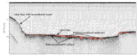
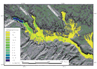
Two reflectors were identified and digitized on the profiles: the lake floor and the preimpoundment surface. Figure 5 shows a part of one of the seismic profiles, and highlights the two reflectors that were identified. The difference between these two reflectors was used to measure the thickness of the post-impoundment sediment, and a velocity of sound of 1,500 m/sec was used to convert thickness from travel time to meters (Fig. 6).
The subbottom profiles effectively penetrated the post-impoundment sediment everywhere except under the delta at the mouth of Las Vegas Wash. Here the thickness and the existence of gravel beds within the deposit precluded full penetration of the delta. To obtain a measure of the thickness of this delta, the preimpoundment topography was generated from a digital elevation data set (U.S.G.S., 1999). This surface was superimposed on each seismic profile and compared to the preimpoundment surface interpreted on each profile. Away from the delta at the mouth of Las Vegas Wash, in general, the two surfaces were within 1 m of each other. Because of this close correlation, we used the preimpoundment surface derived from the digital elevation model as the base of the deltaic deposits off the mouth of Las Vegas Wash.
Bathymetry was measured along the survey tracks.
However because our bathymetric measurements along the track lines were not adequate to resolve the complex morphology, particularly along the edges of the lake, a digital elevation model (U.S.G.S, 1999) based on preimpoundment topography was used for the generalized morphology of the study area (Fig. 7) . This digital elevation model was superimposed on the bathymetric profiles collected during this survey. Away from areas of post-impoundment sediment accumulation, the discrepancies were mostly less than 2 m consequently the continuous coverage of the digital elevation model was viewed as a more effective portrayal of the general morphology of the study area.
1 The use of trade names is for descriptive purposes only and does not indicate endorsement by the U.S. Geological Survey, nor the University of Nevada, Las Vegas. back
|