 |
| Open-File Report 01-0429 |
Environmental Studies of the World Trade Center area after the September 11,
2001 attack.
Version 1.1
Published November 27, 2001
Roger N. Clark1, Robert O. Green2, Gregg A. Swayze1, Greg Meeker1, Steve Sutley1, Todd M. Hoefen1, K. Eric Livo1, Geoff Plumlee1, Betina Pavri2, Chuck Sarture2, Steve Wilson1, Phil Hageman1, Paul Lamothe1, J. Sam Vance3, Joe Boardman4 Isabelle Brownfield1, Carol Gent1, Laurie C. Morath1, Joseph Taggart1, Peter M. Theodorakos1, and Monique Adams1
___________
1U. S. Geological Survey, Denver, Colorado
2Jet Propulsion Lab Pasadena, California
3U.S. Environmental Protection Agency, Region 8 Denver, Colorado
4Analytical Imaging and Geophysics, LLC Boulder, Colorado
Table of Contents
Navigating through this report: At the end of each section will be a link to
the next section in the sequence below, or click on the links to go
directly to a section or sub-section.
|
This web site describes the results of an interdisciplinary environmental characterization
of the World Trade Center (WTC) area after September 11, 2001.
Information presented in this site was first made available to the World Trade
Center emergency response teams on September 18, 2001 (Thermal hot spot information),
and September 27, 2001 (maps and compositional results).
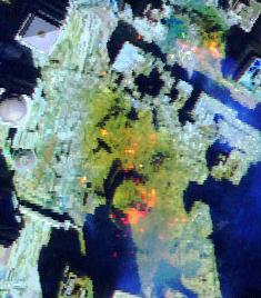
The Airborne Visible / Infrared Imaging Spectrometer (AVIRIS), a hyperspectral
remote sensing instrument, was flown by JPL/NASA over the World Trade Center
(WTC) area on September 16, 18, 22, and 23, 2001 ( Link to the AVIRIS JPL data facility). A 2-person USGS crew collected samples of dusts and airfall debris from more
than 35 localities within a 1-km radius of the World trade Center site on the
evenings of September 17 and 18, 2001. Two samples were collected of indoor
locations that were presumably not affected by rainfall (there was a rainstorm
on September 14). Two samples of material coating a steel beam in the WTC debris
were also collected. The USGS ground crew also carried out on-the-ground reflectance
spectroscopy measurements during daylight hours to field calibrate AVIRIS remote
sensing data. Radiance calibration and rectification of the AVIRIS data were
done at JPL/NASA. Surface reflectance calibration, spectral mapping, and interpretation
were done at the USGS Imaging Spectroscopy Lab in Denver. The dust/debris and
beam-insulation samples were analyzed for a variety of mineralogical and chemical
parameters using Reflectance Spectroscopy (RS), Scanning Electron Microscopy
(SEM), X-Ray Diffraction (XRD), chemical analysis, and chemical leach test techniques in U.S. Geological Survey laboratories
in Denver, Colorado.
Results of these studies to date lead to several important conclusions:
-
The dusts released from the WTC building collapse are largely composed of particles
of glass fibers, gypsum, concrete, paper, and other miscellaneous materials
commonly used in building construction.
-
Laboratory analyses (RS, SEM, XRD) have detected chrysotile asbestos only in
trace levels (less than 1 weight percent) in over two thirds of the dust
and airfall debris samples. To date, no amphibole asbestos minerals have
been detected in any of the dust samples. For definitions of asbestos, CLICK HERE (use the back button on your browser to return here).
-
Laboratory analyses of the material coating a steel beam in the WTC debris have
detected the presence of chrysotile asbestos (a serpentine mineral) at
levels as high as 20% (by volume) of the coating material. No amphibole
asbestos has been detected in this beam coating material.
-
AVIRIS mineral maps do not show widespread distribution of chrysotile or amphibole
asbestos at the few-percent detection limit of the instrument at the ground
surface. AVIRIS mapping keyed to the detection of minerals that may occur
in asbestiform habits has identified isolated pixels or pixel clusters
(each pixel is approximately 2m x 2m) in the area around the WTC. In these
areas, potentially asbestiform minerals might be present in concentrations
of a few percent to tens of percent. Some spectral absorption strengths
in the AVIRIS data are similar to those observed in spectra of the chrysotile
asbestos-bearing beam coating. The absorption features mapped by AVIRIS
only indicate the presence of serpentine mineralogy and not if the serpentine
has asbestos form. Non-asbestiform serpentine minerals can occur naturally
in rocks and such rocks may have been used in building materials. The AVIRIS
maps could indicate areas of higher concentrations of asbestos or simply areas of non-asbestiform mineralogy and would need field sampling and laboratory
analysis to confirm the presence of any asbestos. The AVIRIS maps show
the surface materials only and not any buried materials.
-
AVIRIS mineral maps show a few isolated pixels of amphibole minerals, but these
pixels are isolated with no clusters like those seen in the chrysotile
pixels. The few mapped amphibole pixels are at a statistical noise level
in the WTC area similar to the pixel noise level mapped throughout the
city. The absorptions mapped by AVIRIS only indicate the presence of amphibole
mineralogy, which can occur naturally (non-asbestiform) in rocks that are
used in building materials, and field sampling of those pixels would be
necessary to confirm the presence of asbestos. The AVIRIS maps of serpentine
chrysotile and amphibole mineralogy are consistent with laboratory analyses
of the field samples.
-
Laboratory analyses and the AVIRIS mapping results indicate the dusts are variable
in composition, both on a fine scale within individual samples and on a
coarser spatial scale based on direction and distance from the WTC. Replicate
mineralogical and chemical analyses of material from the same sample reveal
variability that presumably is due to the heterogeneous mixture of different
materials comprising the dusts. The spatial variability is observed at
large scales of tens of meters to centimeter and smaller scales. AVIRIS
mapping suggests that materials with higher iron content settled to the
south-southeast of the building 2 collapse center. Chrysotile may occur
primarily (but not exclusively) in a discontinous pattern radially in west,
north, and easterly directions perhaps at distances greater than 3/4 kilometer
from ground zero.
-
Although only trace levels of chrysotile asbestos have been detected in the
dust and airfall samples studied to date, the presence of up to 20 volume
% chrysotile in material coating steel beams in the WTC debris, and the
potential areas indicated in the AVIRIS mineral maps indicates that asbestos
can be found in localized concentrations.
-
Chemical leach tests of the dusts and airfall debris samples indicate that the
dusts can be quite alkaline. When reacted with rain water or wash water
from cleanup efforts, the dusts can produce slightly alkaline to very alkaline
solutions, due to partial dissolution of concrete, gypsum, and glass fiber
particles. Indoor dust samples generated the highest pH levels (11.8) in
the leach tests, indicating that dusts that have not been exposed to rainfall
since September 11th are substantially more alkaline than those that have
been leached by rainfall.
-
At least some heavy metals and metalloids (such as aluminum, chromium, antimony,
molybdenum, and barium) are readily leached from the dusts into rain or
wash water. Indoor dust samples showed greater proportions of leachable
metals than outdoor dust samples. These metals may also be potentially
bioavailable if the dusts are accidentally inhaled or ingested. Chemical
leach tests of the material coating steel girders in the WTC debris indicate
that the coatings can contain soluble chromium.
-
AVIRIS data collected on September 16, 2001, revealed a number of thermal hot
spots in the region where the WTC buildings collapsed. Analysis of the
data indicated temperatures greater than 800oF in these hot spots (some over 1300oF) . Over 3 dozen hot spots of varying size and temperature were present in the
core zone of the WTC. By September 23, most of these fires that were observable
from an aircraft had been eliminated or reduced in intensity.
-
Our finding that trace levels of asbestos are present in the dust samples is
consistent with results of other studies carried out by the U.S.Environmental
Protection Agency (www.epa.gov). Our results provide further clarification by showing that 1) elevated concentrations
of asbestos may be present in beam coatings and possible localized area
as indicated by the AVIRIS maps, and 2) asbestos in the dusts and beam
coating materials is composed only of chrysotile asbestos and does not
contain amphibole asbestos. A significant body of research conducted over
the last twenty years by toxicologists, epidemiologists and mineralogists
has indicated that chrysotile asbestos is less carcinogenic than the amphibole
asbestos minerals (Ross, 1999; Skinner et al., 1988; Van Oss et al., 1999;
McDonald, 2001). This conclusion, however, has not been universally accepted
by the scientific community. A recent and thorough discussion of these
ongoing issues can be found in Nolan, et al. (2001).
-
Results of our mineralogical characterization studies, chemical leach tests,
and AVIRIS mapping provide further support for the EPA and New York Department
of Public Health recommendations that cleanup of dusts and the WTC debris
should be done with appropriate respiratory protection and dust control
measures. These results include: the presence of up to 20 volume % chrysotile
in material coating steel beams in the WTC debris (which could be unintentionally
released into the air as dust during cleanup); the small areas in the AVIRIS
mineral maps indicating that asbestos might be found in localized concentrations
in the dusts; the highly alkaline nature of the dusts; and, the presence
of potentially bioavailable metals in the dusts.
-
For information on the health aspects of the dusts, readers are referred to
web sites of the EPA: (http://www.epa.gov) and New York department of Public Health: ( http://www.nyc.gov/html/em/health.html, and http://www.nyc.gov/html/doh/html/alerts/911.html)
|
Next section: continue to the Introduction, below.
Back to Table of Contents
The information in this report describes the results of an interdisciplinary
environmental characterization of the World Trade Center (WTC) area following
requests from other Federal agencies after the attack on September 11, 2001.
The scientific investigation included two main aspects: 1) imaging spectroscopy
mapping of materials to cover a large area around the WTC and 2) laboratory
analysis of samples collected in the WTC area.
Spectroscopy is a tool that detects chemical bonds in molecules (solid, liquid
or gas) through absorption (or emission) features in the spectrum of the material.
Imaging spectroscopy obtains a spectrum for every spatial pixel in an image
format. Data from the Airborne Visible/Infrared Imaging Spectrometer (AVIRIS)
were collected over the WTC area by NASA/JPL for this study. The results of
the imaging spectroscopy mapping are shown below.
The analytical techniques applied to this study include X-Ray Diffraction (XRD),
Scanning Electron Microscopy (SEM) with elemental analysis by Energy Dispersive
Spectroscopy (EDS), laboratory Reflectance Spectroscopy (RS), leachable metals,
and X-Ray Fluorescence Spectroscopy (XRF).
For definitions of asbestos, CLICK HERE (use the back button on your browser to return here).
Next section: click on the link to Results of Imaging Spectroscopy Mapping, below
Back to Table of Contents
|
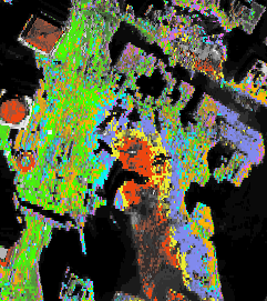
Click on the link above to see:
-
Thermal Hot Spot Maps: Sept 16 and 23, 2001
-
Asbestiform Minerals Map
-
Dust and Debris Plume Map
-
Ferrous and Ferric-Bearing Materials Map
-
Clays and other Materials Map
-
Organic Compounds Map
-
Water Sediment Map
|
Back to Table of Contents
Sample Collection in the WTC Area
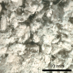
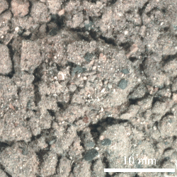
Ground sampling consisted of collecting debris from 35 locations in the WTC
area, including 33 dust, 2 concrete, and 2 steel beam insulation samples.
Optical photographs of a typical dust sample on the left (sample WTC01-27) and
what appeared to be an insulation coating from a steel beam on the right (WTC01-8).
The coating contains as much as 20% chrysotile asbestos. Scale bar is 10 millimeters.
Back to Table of Contents
The objective of the laboratory analysis was to characterize the samples for
potential environmental impacts and to provide feedback to imaging spectral
analysis and field confirmation of the imaging spectroscopy results. In certain
cases the laboratory studies provide better detection levels than airborne
imaging spectroscopy, thus providing complimentary information that allowing
a more robust characterization of the entire site.
Back to Table of Contents
Back to Table of Contents
