|
||||
| U.S. Geological Survey Open-File Report 02-372 |

Physical Properties of Long Island Sound Sediment Cores

Home Page Introduction Methods Data Graphical Presentations Tables H2O vs texture Radionuclides & metals Data Dictionary & Notes Discussion Bibliography Acknowledgments |
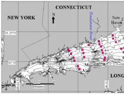
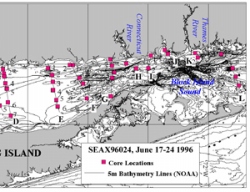
DataSample Location Map
Click here for
larger, printable copy of map (in PDF form). Data are presented in sections accessible through the links below and also the links to the left: 1) Graphical presentations of core x-radiography, water content, and sediment texture. Links for individual cores are accessed through a tabular index of the cores collected. Note that texture plots have the reverse of the standard colors for gravel and sand. Instead of gravel being red and sand being yellow, the plots are colored the opposite way with gravel being yellow and sand being red. 2) Complete tabular data: Location, sectioned intervals, sectioning descriptions, measurements of water content, grain size distribution, and sediment texture statistics. Data tables are available in both Microsoft Excel and comma separated formats. 4) Plots showing water content versus texture (fine fraction). 5) Radionuclides and Selected Metals for cores B1C2, D1C3, D7C4, and G1C1. 5) Data Dictionary and Notes with definitions for the header columns in the Excel and comma-separated files and miscellaneous notes on the data. |
|||||
| Accessibility | FOIA | Privacy | Policies and Notices | |
 |
|