USGS - science for a changing world

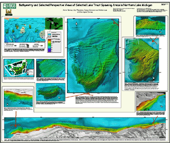
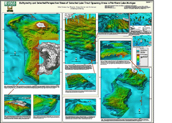
Open-File Report 03-120

Bathymetry and selected perspective views of 6 reef and coastal areas in Northern Lake Michigan.

Posters

Home
Intro
Map Views
  Boulder Reef
  Gull Island Reef
  Little Traverse Bay
  Trout and High Island Reefs
  Hog Island Reef
  Dahlia Shoals
Data
  XYZ
  Grid
Posters
All of the map and perspective views of the 6 reef and coastal areas have been organized into 2 posters that can be downloaded as PDF files. The PDF files can be viewed and printed using free Adobe Acrobat Reader software. Poster 1 includes the areas of Boulder Reef, Little Traverse Bay, and Gull Island Reef, whereas Poster 2 includes the areas of Trout and High Island Reef, Hog Island Reef, and Dahlia Shoals. Click on the PDF link below each poster to download the file.

poster 1

Poster 1 (PDF) 38 Mb

poster 2

Poster 2 (PDF) 54 Mb


Accessibility FOIA Privacy Policies and Notices

Take Pride in America logo USA.gov logo U.S. Department of the Interior | U.S. Geological Survey
URL: http://pubsdata.usgs.gov/pubs/of/2003/0120/posters.html
Page Contact Information: GS Pubs Web Contact
Page Last Modified: Thursday, 03-Apr-2014 12:29:56 EDT