Skip past header information
 Link to USGS Home Page
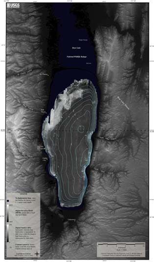
Geophysical Surveys of Bear Lake, Utah-Idaho, September, 2002, OFR 03-150

Skip past index

Data
Sidescan-Sonar

Click on the figure below to view larger image.

The map below displays the sidescan-sonar mosaic generated from the sidescan-sonar data collected within Bear Lake, Utah-Idaho. To view the trackline information see Figure 3, or view these data within the ArcView project file stored on this CD-ROM. See GIS Data for more information.

PDF Format.

Map showing sidescan-sonar mosaic
Figure 6. Map showing sidescan-sonar mosaic of Bear Lake, Utah-Idaho.

To view files in PDF format, download free copy of Adobe Acrobat Reader www.adobe.com/products/acrobat/alternate.html.


Skip past footer information
Title Page / Contents / Project Description / GIS Data / Contacts

U.S. Department of the Interior, U.S. Geological Survey
URL: http://pubs.usgs.gov/of/2003/of03-150/html/SSS.HTM
Maintained by Publishing Services
Last modified: 15:56:56 Thu 16 Oct 2003
Privacy statement | General disclaimer | Accessibility