![]()
Wisconsin Downloadable Gravity Data Files
![]()
The gravity data shown on the index map below have been compressed using standard zip utilities. Information on compression software (commercial software and freeware) is available at: http://www.info-zip.org, http://www.7-zip.org, PowerArchiver 6.1, http://www.winzip.com, http://www.pkware.com/ or http://www.stuffit.com for all platforms.
To Download Files:
PC: right click desired link, choose: "Save Target As..." , and choose "All Files" in the 'Save as type' box (Internet Explorer)
or "Save Link As..." (Netscape)
Macintosh: click and hold, choose "Download Link to Disk..." (Internet Explorer), or "Save This Link As..." (Netscape)
Data Formats: Principal facts list and Digital ASCII data file compressed into a single .zip file
There are 15 sets of digital data files containing the principal facts for the gravity data; one for each of the 14 separate surveys in Wisconsin, plus one that contains all 14 surveys combined into one master file (called wi_gravity_state). The data for each survey have been compressed and are downloadable as “*.zip” files. Each “*.zip” file consists of two files; a “*.lis” file and a “*.asc” file. The file “*.lis” gives the principal facts in table format for readability. The file “*.asc” gives the principal facts in sequence for computer program use and can be directly imported into computer databases or spreadsheets. Note that the values of observed gravity are represented differently in the two files. In the “*.asc” files, a constant of 980,000 has been subtracted from the observed gravity value; in the “*.lis” files, no constant has been removed. Station elevations are listed in feet in the “*.lis” files and in meters in the “*.asc” files.
The FORTRAN format to read the sequential files “*.asc” is (a8,8x,8e16.8), an 8-character id and 8 channels of data.
|
Channel |
FORTRAN |
Format description |
|
ID |
A8, 8x |
Station identification string |
|
1 |
E16.8 |
Longitude in decimal degrees |
|
2 |
E16.8 |
Latitude in decimal degrees |
|
3 |
E16.8 |
Station elevation in meters |
|
4 |
E16.8 |
Observed gravity in mGal with a constant of 980,000 removed |
|
5 |
E16.8 |
Inner terrain correction (Hammer zones a-f) in mGal |
|
6 |
E16.8 |
Outer terrain correction (Hammer zones g-o) in mGal |
|
7 |
E16.8 |
Free-air anomaly in mGal |
|
8 |
E16.8 |
Complete Bouguer anomaly (density=2.67 g/cm3 ) in mGal |
|
Channel |
Format description |
|
ID |
Station identification string |
|
1 |
Latitude in degrees and decimal minutes |
|
2 |
Longitude in degrees and decimal minutes |
|
3 |
Station elevation in feet |
|
4 |
Observed gravity in mGal |
|
5 |
Free-air anomaly in mGal |
|
6 |
Inner terrain correction (Hammer zones a-f) in mGal |
|
7 |
Outer terrain correction (Hammer zones g-o) in mGal |
|
8 |
Complete Bouguer anomaly (density=2.67 g/cm3 ) in mGal |
The “*.lis” files also contain three header lines describing the survey plus column labels. In addition, the file “wi_gravity_state.lis”, which is a combination of all 14 surveys into one single file, contains two additional columns; the data source and the year collected.
Station numbering convention
A standard station numbering convention was used for surveys A, B, C, D, E, F, G, L, M, and O, totaling 38,559 stations out of the total of 40,488 for the state. Examples of the station numbers are "21F-153", "16G117", "13L 8" or "3P 13". The first part of the station number (e.g. "3P" or "21F") refers to a specific 15-minute topographic quadrangle within the state. The leading number starts with "1" at -93o longitude and increases numerically eastward. The letter starts with "A" at 42.25o latitude and increases alphabetically northward. See the image below. The individual gravity stations in each 15-minute quadrangle are numbered sequentially.
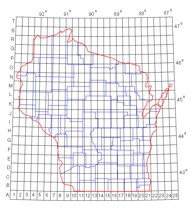
(Click on image to see more detail - county boundaries in blue)
See Misc_QuadCodes.txt for an explanation of the station naming convention for the surveys not listed above.
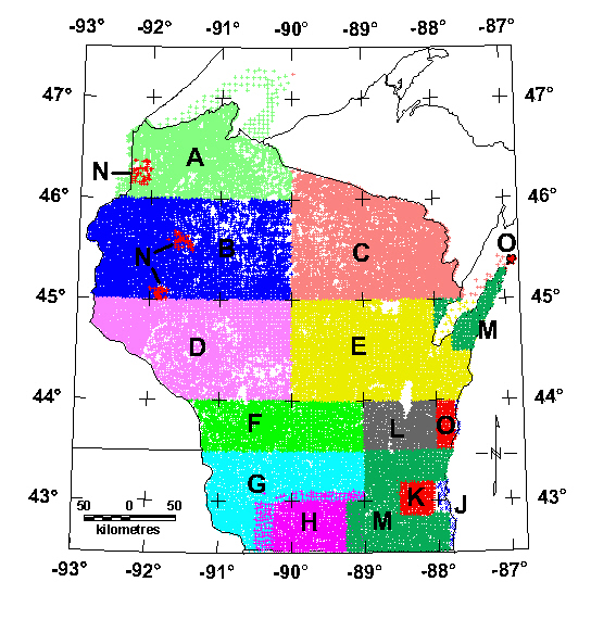
Wisconsin Bouguer Gravity Data Files - Principal Facts:
Wisconsin State Data - Entire state - Click link to download data
Index map of surveys contained in this report.
(Click on image to see more detail)
Click on letter under the column labeled "Index Code" in table below to download each individual survey.
| Index code | Survey description and reference |
| Survey A | Superior sheet by Ervin and Thompson, 1991a |
| Survey B | Northwest sheet by Ervin and Thompson, 1991b |
| Survey C | Northeast sheet by Ervin, 1991 |
| Survey D | West-central sheet by Ervin, 1993 |
| Survey E | East-central sheet by Ervin, 1996 |
| Survey F | Geister 1999, NIU and USGS. |
| Survey G | Geister 2000, NIU and USGS. |
| Survey H | Illinois Deep Drill Holes by Aiken and others, 1983 |
| Survey J | NGDC Data, Dater and others, 1999 |
| Survey K | Waukesha County by Brukardt, 1983 |
| Survey L | Snyder and Daniels, 2000-2001, USGS, Fond du Lac 1:100,000 sheet. |
| Survey M | Geister 2001, NIU and USGS. |
| Survey N | Snyder 1996, USGS. |
| Survey O | Snyder, 2002, USGS, Sheboygan 1:100,000 sheet (plus Washington Island). |
Top || Title Page || Introduction || Gravity Survey Index Map || References
[an error occurred while processing this directive]