
Principal facts for 40,488 gravity stations covering the entire state of Wisconsin are presented here in digital form. This is a compilation of previously published data collected between 1948 and 1992 from numerous sources, along with over 10,000 new gravity stations collected by the USGS since 1999. Also included are 550 gravity stations from previously unpublished sources. Observed gravity and complete-Bouguer gravity anomaly data for this statewide compilation are included here. Altogether, 14 individual surveys are presented here.
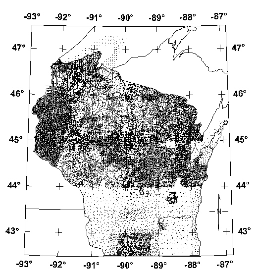
North of latitude 44o N., more than 28,000 stations were compiled by Ervin (1991, 1993, 1996) and Ervin and Thompson (1991a, 1991b) (see Figure 1). These data, collected between 1957 and 1992, include stations from the Wisconsin Geological and Natural History Survey (WGNHS), the National Geophysical Data Center (NGDC), the U.S. Geological Survey (USGS), and Northern Illinois University (NIU). An approximate station interval of 1 mile (1.6 km) was established where possible, but limited access in some areas necessitated a greater spacing. An earlier Bouguer gravity anomaly map of Wisconsin was published by Ervin and Hammer (1974), a compilation of 16,118 stations.
Prior to 1999, the data south of latitude 44o N. totaled approximately 3800 stations from NGDC and from G. Randy Keller (Aiken and others, 1983) (see Figure 1). A USGS effort, begun in 1999, was directed at upgrading the gravity coverage of the state south of latitude 44o N. with a station density comparable to that north of 44o N. This effort was completed in 2002, resulting in 10,393 new gravity stations to achieve a nominal station spacing of 1 mile (see Figure 2). This is made possible by the State of Wisconsin's rectilinear network of roads. These new data replace the older data from the NGDC, which had a nominal station spacing ranging from 3 to 10 miles. All of the data are tied to the Wisconsin First-order Gravity Base Station Network (Ervin, 1983), which in turn, is tied to the International Gravity Standardization Network-1971 (IGSN-71) (Morelli, 1974). Also included are 433 stations from an unpublished Masters Thesis collected in 1983 (Survey code K) (Brukardt, 1983) and 117 unpublished stations collected by the author in northwestern Wisconsin during 1996 (Survey code N).
The rationale for upgrading the gravity coverage has been to provide higher resolution data to assist in the interpretation of the basement geology of southern Wisconsin, much of which is hidden by glacial and Paleozoic cover. The gravity data, along with aeromagnetic data, give clues to the structural evolution of the Precambrian crust, making the map an excellent tool for USGS mineral resource studies. A CD-ROM containing potential fields grids, derivative maps and tectonic interpretations has been published (Daniels and others, 2003). A separate web page describing the compilation of aeromagnetic data for Wisconsin, along with downloadable aeromagnetic and gravity grids has also been published (Daniels and Snyder, 2002). This latter report contains only a preliminary grid of the data presented in this report.
 |
 |
|
Figure 1. Pre-1999 coverage of published gravity data. Click on image to view greater detail. |
Figure 2. Final coverage of Wisconsin gravity data. Click on image to view greater detail. |
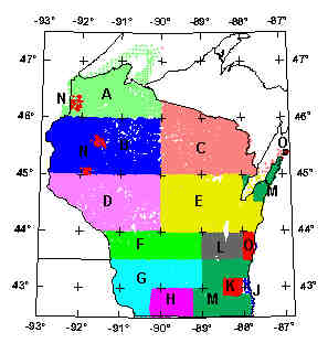
Click on above image to view index map in greater detail and to view the specifications of each survey.
Field surveys were undertaken in 1996 and from 1999 through 2002 to fill in gaps in existing gravity data coverage in Wisconsin. The new gravity measurements were acquired by the USGS using LaCoste-Romberg gravity meters G-159, G-226 and G-695. Data for survey N was collected with USGS LaCoste-Romberg gravity meter G-159. Data for surveys L and O were collected with USGS LaCoste-Romberg gravity meter G-695. Northern Illinois University's LaCoste-Romberg gravity meter G-226 was used to collect data for surveys F, G, and M. Field notes from the surveys are available from the USGS but are not included in this report.
All of the new data are ultimately tied to the Wisconsin First-order Gravity Base Station Network (Ervin, 1983), which in turn, is tied to the International Gravity Standardization Network-1971 (IGSN-71) (Morelli, 1974, p.18). Eight of Ervin's stations were used directly as local gravity base stations, plus 16 other field bases were established by making repeated loops between one of Ervin's base stations and the new field base station. These stations were generally established on bench marks found on US Geological Survey topographic maps. Survey loops were performed by making beginning and ending repeat observations at one of the gravity base stations.
The station positions and elevations were obtained from benchmarks, spot elevations, and other locations given on USGS 1:24,000 scale topographic maps. Horizontal positions were determined in the field using Garmin III Plus and Trimble Scoutmaster GPS units. The uncertainty of elevations based on benchmarks is less than 0.5 foot (0.15 m). For spot elevations and section corners with elevations printed in black on 1:24,000 scale topographic maps, the uncertainty is assumed to be within one-tenth (0.1) of the contour interval (USGS national map accuracy standards). For Wisconsin, all of the topographic maps have a contour interval of 10 feet, therefore the elevation uncertainty is within one foot. At a density of 2.67 g/cm3, elevation uncertainty translates to a maximum in the Bouguer anomaly values of approximately 0.06 mGal/foot.
The gravity data for surveys L, N and O were processed using the Geosoft Oasis montaj "Xcelleration Gravity Processing System." Observed gravity values were based on an assumed linear drift between successive base readings. The gravity data were reduced using the Geodetic Reference System of 1967 (International Union of Geodesy and Geophysics, 1971) and referenced to the International Gravity Standardization Net 1971 (IGSN-71) gravity datum (Morelli, 1974, p.18). Gravity data were reduced to complete Bouguer anomaly using a reduction density of 2.67 g/cm3 and include earth-tide, instrument drift, free-air, Bouguer, latitude, curvature and terrain corrections. The 1967 latitude correction formula used by Geosoft can be found in Sheriff, 1984 (p. 141). The curvature (Bullard B) correction was computed using LaFehr's formula (LaFehr, 1991). The free-air correction is defined by Swick, (1942, p. 65).
The gravity data for surveys F, G and M were processed using software written at Northern Illinois University.
Terrain corrections for all of the surveys were computed using a computer algorithm by Godson and Plouff (1988) correcting for the gravity effects of terrain to 166.7 km outward from each station using a method by Hammer (Hammer, 1939), in which average elevation estimates within circular zones surrounding the station are used to compute the gravity effect of each zone. A digital elevation model with a 15 arc-second sample interval (digitized from USGS 1:250,000 scale topographic maps) was used closest to the station. Outer-zone terrain corrections for 0.895 km (Hammer zone G) to 166.7 km from each station were computed using the computer algorithm of Godson and Plouff (1988). This algorithm computes gravity effects based on digital elevation models having different sample intervals, taking advantage of decreased need for close sample spacings at great distances from the station. No inner-zone terrain corrections (Hammer zones A-F) nor hand terrain corrections were made for the data in this report. The data files in this report have a column for inner-zone terrain corrections, however this column shows all zeros.
Projection Specifications:
Appreciation is extended to Michael G. Mudrey, Jr., of the Wisconsin Geological and Natural History Survey, Madison, WI, for logistical support. This report was supported by the Surveys and Analysis project, Suzanne W. Nicholson, project chief, as part of the Minerals Resources Program of the USGS. Thanks to USGS colleagues Robert Kucks, Joseph Duval, and Donald Plouff for their assistance in preparing this report.
Top || Title Page || Gravity Survey Index Map || References || Data
For more information about this report contact: Stephen Snyder
[an error occurred while processing this directive]