
![]()
Gravity Surveys in Wisconsin
![]()
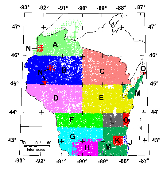
Index map of surveys contained in this report.
Table of Wisconsin Gravity Surveys
| Survey Code | Year(s) Collected | Data Source and brief description - References | |
|---|---|---|---|
| A | 4462 | 1972-1989 | Ervin and Thompson, 1991a - Superior sheet |
| B | 6733 | 1957-1989 | Ervin and Thompson, 1991b - Northwest sheet |
| C | 6336 | 1957-1982 | Ervin, C.P., 1991 - Northeast sheet |
| D | 4750 | 1972-1992 | Ervin, C.P., 1993 - West-central sheet |
| E | 5885 | 1972-1992 | Ervin, C.P., 1996 - East-central sheet |
| F | 2325 | 1999 | Geister, D.W., NIU1, and USGS, south-central WI. |
| G | 3146 | 2000 | Geister, D.W., NIU1, and USGS, southwest WI. |
| H | 1330 | 1980 | Illinois Deep Drill Holes by Aiken and others, 1993 |
| J | 49 | various | NGDC Data, Dater and others, 1999 |
| K | 433 | 1983 | Brukardt, S.A., 1983, Waukesha County. Unpublished master's thesis: written communication from William Kean, University of Wisconsin, Milwaukee, 2001. |
| L | 1346 | 2000-2001 | Snyder, S.L. and Daniels, D.L., USGS, Fond du Lac 1:100,000 sheet. |
| M | 3237 | 2001 | Geister, D.W., NIU1, and USGS, southeast WI and Door Peninsula. |
| N | 117 | 1996 | Snyder, S.L., USGS, northwest WI. |
| O | 339 | 2002 | Snyder, S.L., USGS, Sheboygan 1:100,000 sheet and Washington Island. |
| Total | 40,488 | 1 Northern Illinois University, DeKalb, IL |
Top || Title Page || Introduction || References || Data
[an error occurred while processing this directive]