Coastal-Storm Vulnerability
 |
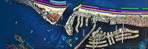
| Figure 11. Storm-surge channels on Mustang and North Padre Islands opened by Hurricane Beulah in 1967. [larger version] |
For this report, storm vulnerability refers to the potential impacts related to storm surge, waves, and associated currents. These storm processes cause beach and dune erosion, overwash, and onshore sediment transport. The storm-vulnerability discussion does not consider potential property damage related to high wind and heavy rain. The potential storm vulnerability of a particular segment of coast depends on a number of variables including storm and land characteristics. The most important storm parameter used to evaluate storm vulnerability is the high-water levels caused by high waves superimposed on the storm surge. The interaction between coastal storms and the shoreline is complex, and our present scientific understanding of this interaction is still limited; therefore, storm vulnerability cannot be quantified precisely. Despite the limitations, the map classifications and ground elevations presented in this report provide a basis for relative comparisons of storm vulnerability.
Natural or man-made features that dissipate wave and current energy or block the overland flow of storm water provide some protection to upland structures and reduce the storm vulnerability. For example, impact vulnerability for most storms is low where the beaches are wide, the natural dunes are several meters high and continuous along the beach, and the dunes are stabilized with vegetation. Storm vulnerability can also be reduced by engineering structures such as seawalls and riprap aligned parallel to the shore. Buildings that are not elevated above the ground can also prevent or reduce the inland transmission of waves if they are able to withstand wave energy and scouring caused by the currents. Conversely, houses that are elevated on pilings allow floodwaters to flow landward. Storm vulnerability is high for those areas where the beach is narrow, dunes are low and discontinuous, and dune vegetation is sparse. The presence of an overwash terrace is convincing evidence that the area has been submerged by storm waves in the past and is vulnerable to future storm impacts.
Another potential storm hazard on barrier islands is breaching of new inlets. Narrow barrier island segments that have elevations less than 2 m high and that are far from tidal inlets are the most susceptible to breaching by an extreme storm. This is because storm surges not only exceed the dune heights, they also exceed the adjacent lagoon level, creating a hydraulic head that incises channels across the narrow barrier (Morton, 2002). The Central Texas coast has been the site of several historical reopenings of former inlets at Newport Pass, Corpus Christi Pass, and Packery Channel (Fig. 11). The seaward ends of these storm channels filled within several months, reestablishing a continuous beach along the Gulf shore.
continue to: Classification Summary
 |