Western Coastal and Marine Geology
1Coastal and Marine Geology, USGS, Pacific Science Center, Santa Cruz, Calif.
2Coastal and Marine Geology, USGS Geological Survey, Menlo Park, Calif.
3Minerals Management Service, Camarillo, Calif.
|
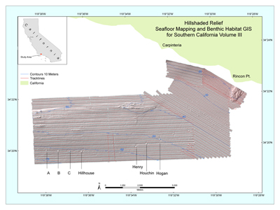
Figure 1. Location map of Seafloor Mapping and Benthic Habitat GIS for Southern California, Vol. III. Letters and names with pointers refer to offshore oil platforms. To view a large version of Figure 1 in a new window, click on the image above. Note: On June 18, 2010, Secretary of the Interior Ken Salazar signed a Secretarial Order formally changing the name of the Minerals Management Service to the Bureau of Ocean Energy Management, Regulation and Enforcement (BOEMRE). AbstractFrom August 8-27, 2005, more than 75 km of the continental shelf (Fig. 1) in water depths of 20-70m southeast of Santa Barbara, were surveyed during the USGS cruise S-1-05-SC (http://walrus.wr.usgs.gov/infobank/s/s105sc/html/s-1-05-sc.meta.html). Both Interferometric sonar and 14 hours of both vertical and oblique georeferenced submarine digital video were collected to (1) obtain geophysical data (bathymetry and acoustic reflectance), (2) examine and record geologic characteristics of the sea floor, and (3) construct maps of seafloor geomorphology and habitat distribution. Substrate distribution is predicted using a modified version of Cochrane and Lafferty (2002) video-supervised statistical classification of sonar data that includes derivatives of bathymetry data. Specific details of the methods can be found in the meatadata of the bathymetry data file. Substrates observed are predominantly sand with some rock. Rocky substrates were restricted primarily to an east-west trending bathymetric high 2,000 m north of oil platforms. This is an updated report (version 2.0) from the earlier 2007-1271 (version 1.0) open-file report. This updated report re-releases the data files in UTM, zone 11, WGS84 coordinates. Also, the bathymetry data has been corrected for a vertical offset discovered in the earlier 2007-1271 (version 1.0) report. Citation: Cochrane, G.R., Golden, N.E., Dartnell, P., Schroeder, D.M., and Finlayson, D.P., 2007, Seafloor Mapping and Benthic Habitat GIS for Southern California, Volume III. U.S. Geological Survey Open-File Report 2007-1271. Available online at https://pubs.usgs.gov/of/2007/1271/. IntroductionGeologic substrates of the sea floor in southern California provide potential benthic habitats for recreationally and commercially important species, including rockfish. The study of rockfish habitat structure, function, and change is particularly important in the Santa Barbara Channel, where oil platforms function as de-facto marine protected areas. The U.S. Geological Survey (USGS) in cooperation with the Minerals Management Service (MMS), conducted sonar mapping in the eastern Santa Barbara Channel aboard the R/V Shearwater during the period August 8 to August 27, 2005. MMS is interested in maps of hard-bottom substrates, particularly natural outcrops that support reef communities in areas affected by oil and gas activity. Such maps are also useful to biologists studying fish that use the platforms and the sea floor beneath them as habitat. Video observations of the seafloor were logged real-time in the field by a team of geologists and biologists who examined areas of transition between contrasting substrate types, resolved and characterized unique seafloor features, and linked the geology and biology of benthic environments. Common substrates observed include a mixture of mud and sand. Common subtidal biota observed include benthic and demersal fish and sessile invertebrates such as gorgonians, sea pens, echinoderms, anemones, sponges, and urchins. Bathymetic and acoustic backscatter data were compiled with geologic and biologic video observations in an ESRI Geographic Information Systems database (ArcGIS) and used to construct maps of geologic substrate and habitat distribution, Greene et al. (1999). These map products that enable scientists, parks, and resource managers to better understand benthic habitat characteristics. This information is increasingly important in making decisions about the management of critical environments and resources, the design and utility of marine reserves, and policies on tourism and development. The purpose of this report is to make these data and imagery available for public use. This is an updated report (version 2.0) from the earlier 2007-1271 (version 1.0) open-file report. This updated report re-releases the data files in UTM, zone 11, WGS84 coordinates. Also, the bathymetry data has been corrected for a vertical offset discovered in the earlier 2007-1271 (vesion 1.0) report. Revisions and UpdatesThis GIS compilation may be revised and updated as new data become available, and changes will be posted online. Subsequent versions of the GIS will be available at http://walrus.wr.usgs.gov/nearshorehab. Changes to the GIS will be described in the Revision History section of an update OFR. The hosting site could change. If there is no forwarding link, go the USGS home page (usgs.gov) and search for keywords "benthic habitat." File and Data FormatsText files (.txt) on the web site may be viewed without special software. Hypertext mark-up language files (.html) require a browser such as Netscape Navigator or Internet Explorer. JPEG (.jpg) or TIFF (.tif) images may be viewed by many common image software packages. The GIS data files require ESRI ArcExplorer, ArcView, or ArcInfo. ArcExplorer is an application that ESRI licenses without charge for Windows operating systems. ArcView and ArcInfo are licensed applications that must be purchased. Please note that any use of trade, product, or firm names is for descriptive purposes only and does not imply endorsement by the U.S. Government. The data were compiled in ArcInfo (versions 9.1; ESRI 2005), a commercial GIS, in the UTM Zone 10 coordinate system with datum WGS84. Raster data layers are in ArcInfo GRID format or are registered TIFF images. Point, line and polygon features are in ESRI shapefile format. Shapefiles were generated in geographic coordinates with datum WGS84. Each data layer is accompanied by Federal Geographic Data Committee (FGDC) compliant metadata and an overview map. AcknowledgmentsThe authors would like to thank Mike Boyle, Gerry Hatcher, Larry Kooker, and Andy Stevenson of the USGS for mobilization and operation of the sonar and camera systems. Hank Chezar of the USGS designs and maintains the bottom video camera systems. Terrance Shinn and Lumon Moody of the Channel Islands National Marine Sanctuary skippered the R/V Shearwater. The Channel Islands National Marine Sanctuary contributed ship time for this project. This publication benefited from technical reviews by Brian Edwards and Curt Storlazzi. ReferencesAnderson, T.J., Cochrane, G.R., Roberts, D.A., Chezar, H., and Hatcher, G., in press, A systematic real-time method to characterize seafloor habitats and benthic macro-organisms: Habitat mapping with a side-scan sonar and towed camera-sled, in press. Proceedings, Geohab Conference, Victoria, British Columbia, 4-7 May 2005. Cochrane, G.R. and Lafferty, K.D., 2002. Use of acoustic classification of sidescan sonar data for mapping benthic habitat in the Northern Channel Islands, California: Continental Shelf Research, v. 22, p. 683-690. Environmental Systems Research Institute (ESRI), 2005. ArcGIS 9.2--computer software. Environmental Systems Research Institute, Inc., Redlands, California. Gann, J.T., 1992, YoNav: your own integrated navigation system for DOS platforms: U.S. Geological Survey Open-File Report 92-565, 62 p. Greene, G.H., Yoklavich, M.M, Starr, R.M., O'Connell, V.M., Wakefield, W.W., Sullivan, D.E., McRea, J.E., and Cailliet, G.M., 1999, A classification scheme for deep seafloor habitats: Oceanologica Acta, v. 22, p. 663-678. Lundblad, E., Wright, D.J., Miller, J., Larkin, E.M., Rinehart, R., Battista, T., Anderson, S.M., Naar, D.F., and Donahue, B.T., 2006. A benthic terrain classification scheme for American Samoa, Marine Geodesy, 26(2): 89-111. USGS, Coastal and Marine Geology InfoBank, 2005. http://walrus.wr.usgs.gov/infobank/s/s105sc/html/s-1-05-sc.meta.html For more information, contactGuy R. Cochrane |
Project Description Abstract Introduction Revisions and Updates File and Data Formats Acknowledgments References Contacts Methods Sonar Data Sea Floor Video Data Processing Seafloor Classification Mega Habitat Seafloor Induration Meso/Macrohabitat Modifier Slope,Complexity, and Depth Results Seafloor Features Substrate Common Biota Fish Biomass Sand Ripples Habitat Classification Map Table Data Catalog Revision History |
|||||||
|
||||||||

![]() U.S. Department of the Interior | U.S. Geological Survey
U.S. Department of the Interior | U.S. Geological Survey
URL: https://pubs.usgs.gov/of/2007/1271/
Page Maintained By: Michael Diggles
Page Contact Information: Guy R. Cochrane
Page Last Modified: December 30, 2010 (mfd)