U.S. Geological Survey Open-File Report 2008-1196
| Enhanced Sidescan-Sonar Imagery Offshore of Southeastern Massachusettsby L.J. Poppe¹, K.Y. McMullen¹, S.J. Williams¹, S.D. Ackerman², K.A. Glomb³, and N.A. Forfinski³ Published 2008
|
¹ U.S. Geological Survey, Woods Hole Science Center, Woods Hole,
MA 02543
² Massachusetts Office of Coastal Zone Management, Woods Hole Science Center, Woods Hole,
MA 02543
³ Office of Coast Survey, National Oceanic and Atmospheric Administration, Norfolk, VA 23510
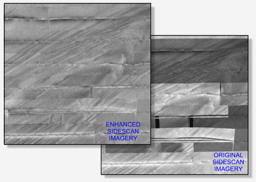
The U.S. Geological Survey (USGS), National Oceanic and Atmospheric Administration (NOAA), and Massachusetts Office of Coastal Zone Management (CZM) have been working cooperatively to map and study the coastal sea floor. The sidescan-sonar imagery collected during NOAA hydrographic surveys has been included as part of these studies. However, the original sonar imagery contains tonal artifacts from environmental noise (for example, sea state), equipment settings (for example, power and gain changes), and processing (for example, inaccurate cross-track and line-to-line normalization), which impart a quilt-like patchwork appearance to the mosaics. These artifacts can obscure the normalized backscatter properties of the sea floor. To address this issue, sidescan-sonar imagery from surveys H11076 and H11079 offshore of southeastern Massachusetts was enhanced by matching backscatter tones of adjacent sidescan-sonar lines. These mosaics provide continuous grayscale perspectives of the backscatter, more accurately reveal the sea-floor geologic trends, and minimize the environment-, acquisition-, and processing-related noise.
The datasets contained in this report have been approved for release and publication by the USGS. Although these datasets have been subjected to rigorous review and are substantially complete, the USGS reserves the right to revise the data pursuant to further analysis and review. Furthermore, they are released on condition that neither the USGS, the National Oceanic and Atmospheric Administration (NOAA), Massachusetts Office of Coastal Zone Management (CZM), nor the U.S. Government may be held liable for any damages resulting from their authorized or unauthorized use.
Any use of trade, product, or firm names is for descriptive purposes only and does not imply endorsement by the U.S. Government.
![]()

![]() U.S. Department of the Interior |
U.S. Geological Survey
U.S. Department of the Interior |
U.S. Geological Survey
URL: http://pubsdata.usgs.gov/pubs/of/2008/1196/index.html
Page Contact Information: GS Pubs Web Contact
Page Last Modified: Wednesday, 07-Dec-2016 21:36:41 EST