DH_NOAA_backscatter1m: Composite sidescan-sonar mosaic collected by the National Oceanic and Atmospheric Administration offshore of Massachusetts in the approaches to Boston Harbor near Hull (UTM Zone 19N GeoTIFF)

Metadata also available as - [Outline] - [Parseable text]

Frequently-anticipated questions:


What does this data set describe?

Title:
DH_NOAA_backscatter1m: Composite sidescan-sonar mosaic collected by the National Oceanic and Atmospheric Administration offshore of Massachusetts in the approaches to Boston Harbor near Hull (UTM Zone 19N GeoTIFF)
Abstract:
These data were collected under a cooperative agreement with the Massachusetts Office of Coastal Zone Management (CZM) and the U.S. Geological Survey (USGS), Coastal and Marine Geology Program, Woods Hole Science Center (WHSC). Initiated in 2003, the primary objective of this program is to develop regional geologic framework information for the management of coastal and marine resources. Accurate data and maps of sea-floor geology are important first steps toward protecting fish habitat, delineating marine resources, and assessing environmental changes due to natural or human impacts. The project is focused on the inshore waters (5-30 m deep) of Massachusetts between the New Hampshire border and Cape Cod Bay. Data collected for the mapping cooperative have been released in a series of USGS Open-File Reports (<http://woodshole.er.usgs.gov/project-pages/coastal_mass/html/current_map.html>). This spatial dataset is from the study area located between Duxbury and Hull Massachusetts, and consists of high-resolution geophysics (bathymetry, backscatter intensity, and seismic reflection) and ground validation (sediment samples, video tracklines and bottom photographs). The data were collected during four separate surveys conducted between 2003 and 2007 (NOAA survey H10993 in 2003, USGS-WHSC survey 06012 in 2006, and USGS-WHSC surveys 07001 and 07003 in 2007) and cover more than 200 square kilometers of the inner continental shelf.
  1. How should this data set be cited?

    U.S. Geological Survey, 2010, DH_NOAA_backscatter1m: Composite sidescan-sonar mosaic collected by the National Oceanic and Atmospheric Administration offshore of Massachusetts in the approaches to Boston Harbor near Hull (UTM Zone 19N GeoTIFF): Open-File Report 2009-1072, U.S. Geological Survey, Coastal and Marine Geology Program, Woods Hole Science Center, Woods Hole, MA.

    Online Links:

    This is part of the following larger work.

    Barnhardt, Walter A. , Ackerman, Seth D. , Andrews, Brian D. , and Baldwin, Wayne E. , 2010, Geophysical and Sampling Data from the Inner Continental Shelf: Duxbury to Hull, Massachusetts.: Open-File Report 2009-1072, U.S. Geological Survey, Coastal and Marine Geology Program, Woods Hole Science Center, Woods Hole, Massachusetts.

    Online Links:

  2. What geographic area does the data set cover?

    West_Bounding_Coordinate: -70.833278
    East_Bounding_Coordinate: -70.721592
    North_Bounding_Coordinate: 42.349316
    South_Bounding_Coordinate: 42.257596

  3. What does it look like?

    <https://pubs.usgs.gov/of/2009/1072/GIS/browse_jpg/big/DH_NOAA_backscatter1m.jpg> (JPEG)
    grey scale image of multibeam-echosounder backscatter mosaic

  4. Does the data set describe conditions during a particular time period?

    Beginning_Date: 20-Aug-2003
    Ending_Date: 03-Oct-2003
    Currentness_Reference: ground condition

  5. What is the general form of this data set?

    Geospatial_Data_Presentation_Form: remote-sensing image

  6. How does the data set represent geographic features?

    1. How are geographic features stored in the data set?

      This is a Raster data set. It contains the following raster data types:

      • Dimensions 13001 x 9001 x 1, type Pixel

    2. What coordinate system is used to represent geographic features?

      Grid_Coordinate_System_Name: Universal Transverse Mercator
      Universal_Transverse_Mercator:
      UTM_Zone_Number: 19
      Transverse_Mercator:
      Scale_Factor_at_Central_Meridian: 0.999600
      Longitude_of_Central_Meridian: -69.000000
      Latitude_of_Projection_Origin: 0.000000
      False_Easting: 500000.000000
      False_Northing: 0.000000

      Planar coordinates are encoded using row and column
      Abscissae (x-coordinates) are specified to the nearest 1.000000
      Ordinates (y-coordinates) are specified to the nearest 1.000000
      Planar coordinates are specified in meters

      The horizontal datum used is D_WGS_1984.
      The ellipsoid used is WGS_1984.
      The semi-major axis of the ellipsoid used is 6378137.000000.
      The flattening of the ellipsoid used is 1/298.257224.

  7. How does the data set describe geographic features?

    Entity_and_Attribute_Overview:
    There are no attributes associated with a GeoTIFF image. Image pixel values contain acoustic reflectivity values normalized to an 8-bit data range (0-255) with the data range 0-254. Low-backscatter is represented by dark tones (low values) and high-backscatter is represented by bright tones (high values). The background color is set to 255 and can be turned off without removing data values.
    Entity_and_Attribute_Detail_Citation: U.S. Geological Survey


Who produced the data set?

  1. Who are the originators of the data set? (may include formal authors, digital compilers, and editors)

  2. Who also contributed to the data set?

  3. To whom should users address questions about the data?

    Seth Ackerman
    U.S. Geological Survey
    Geologist
    384 Woods Hole Rd.
    Woods Hole, MA 02543-1598
    USA

    508-548-8700 x2315 (voice)
    508-457-2310 (FAX)
    sackerman@usgs.gov


Why was the data set created?

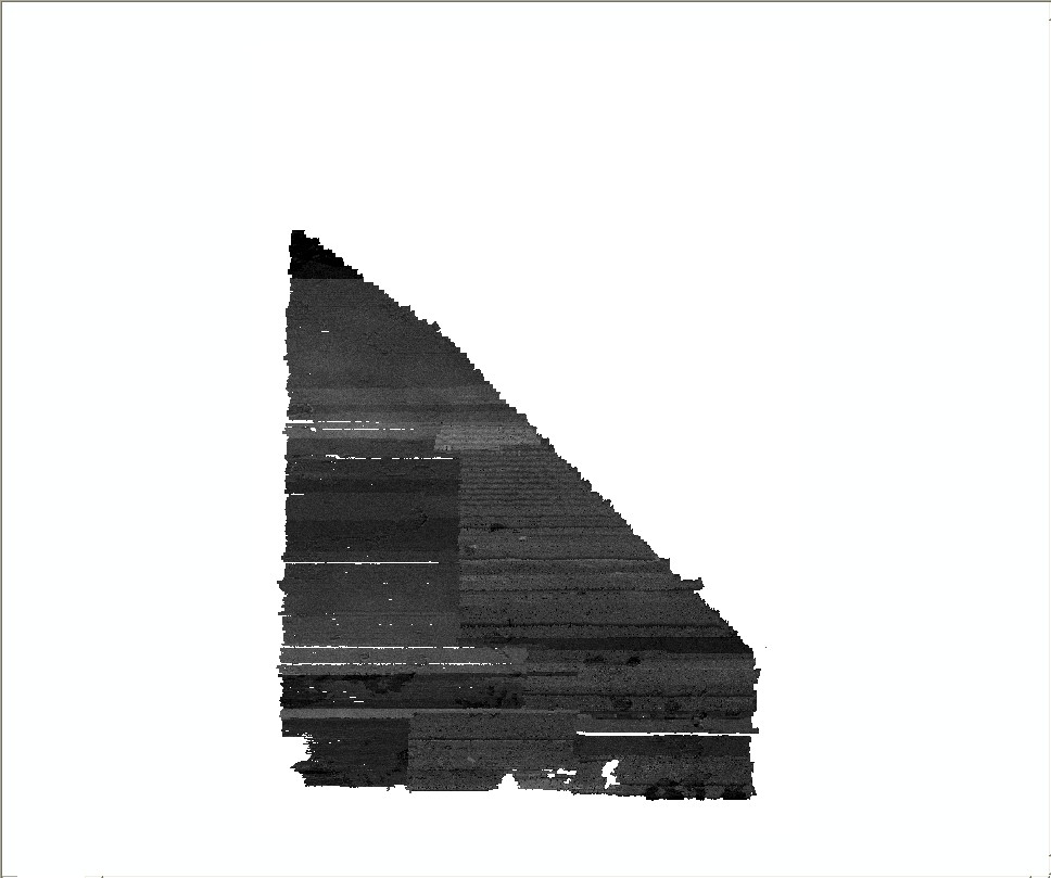
This GeoTIFF (Tagged Image File Format) contains approximately 45 square-km of RESON SeaBat 8101 and 8125 multibeam-echosounder backscatter data that were collected by the National Oceanic and Atmospheric Administration during hydrographic survey H10993 offshore of Massachusetts, in the approaches to Boston Harbor near Hull. These data are used to define the sea-floor morphology as part of the Massachusetts Sea-floor Mapping Project.


How was the data set created?

  1. From what previous works were the data drawn?

    (source 1 of 1)
    U.S. Geological Survey.

    Type_of_Source_Media: disc
    Source_Contribution:
    For NOAA Hydrographic survey H10993: Launch 1005 acquired multibeam-echosounder data using a hull-mounted RESON SeaBat 8101 multibeam system. All positioning and attitude on Launch 1005 were determined with a TSS POS/MV 320 (version 2) GPS aided inertial navigation system. Launch 1014 acquired multibeam-echosounder data using a hull-mounted RESON SeaBat 8125 multibeam system. For continuous refraction correctors at the transducer, a Digibar Pro was used for the surface sound velocity and all positioning and attitudes on Launch 1014 were determined with a TSS POS/MV 320 (version 3) GPS-aided inertial navigation system. The RESON SeaBat 8101 is a 1.5 deg beam angle system which operates at a frequency of 240 kHz and collects 101 individual soundings in a swath oriented perpendicular to the vessel track. The RESON SeaBat 8125 is a 0.5 deg beam angle system which operates at a frequency of 455 kHz and collects 240 individual soundings in a swath oriented perpendicular to the vessel track. Sounding positional control was determined using the Global Positioning System (GPS) corrected by U.S. Coast Guard differential GPS (DGPS) beacon stations. The primary and only DGPS beacon used for this survey was Portsmouth Harbor, NH (Beacon # 771). No horizontal control stations were established for this survey. NOAA's Computer Aided Resource Information System (CARIS) directory with all of the processed multibeam bathymetric data was provided to the USGS. The raw eXtended Triton Format (XTF) multibeam backscatter data from NOAA survey H10993 was also delivered to the USGS where it was processed using a radiometric-correction technique developed by the Ocean Mapping Group and the University of New Brunswick (Beaudoin and others, 2002). Refer to the Fall Data Acquisition and Processing Report (DAPR) and the Horizontal and Vertical Control Report, for detailed equipment, vessel configuration and setting information.

    No additional visual enhancement was performed. Significant tonal variation occurs in this dataset as a result of the system parameters during acquisition.

  2. How were the data generated, processed, and modified?

    Date: 2008 (process 1 of 4)
    The raw eXtended Triton Format (XTF) multibeam backscatter data from NOAA survey H10993 was also delivered to the USGS where it was processed (in SwathEd, build January2008) using a radiometric-correction technique developed by the Ocean Mapping Group and the University of New Brunswick (Beaudoin and others, 2002).

    Person who carried out this activity:

    Seth Ackerman
    U.S. Geological Survey
    Geologist
    384 Woods Hole Rd.
    Woods Hole, MA 02543-1598

    (508) 548-8700x2315 (voice)
    (508) 457-2310 (FAX)
    sackerman@usgs.gov

    Date: 2009 (process 2 of 4)
    Each survey day was individually mosaicked into a separate mosaic file (MOS) with the bounds of the entire H10993 survey area and converted to a Portable GrayMap image (PGM) using SwathEd (build January2008) software. The PGM files were then converted to TIFF images using ImageMagick (v6.3.7). TIFF World Files (TFW) were created for each TIFF image from the MOS files using the SwathEd command "edhead."

    Person who carried out this activity:

    Seth Ackerman
    U.S. Geological Survey
    Geologist
    384 Woods Hole Rd.
    Woods Hole, MA 02543-1598

    (508) 548-8700x2315 (voice)
    (508) 457-2310 (FAX)
    sackerman@usgs.gov

    Date: 2009 (process 3 of 4)
    The TIFF images for each individual survey day were combined using Adobe Photoshop (CS2); the backscatter from the hull-mounted multibeam system displayed no layback offset that needed to be accounted for. No additional visual enhancement was performed. Significant tonal variation occurs in this dataset as a result of the system parameters during acquisition.

    Person who carried out this activity:

    Seth Ackerman
    U.S. Geological Survey
    Geologist
    384 Woods Hole Rd.
    Woods Hole, MA 02543-1598

    (508) 548-8700x2315 (voice)
    (508) 457-2310 (FAX)
    sackerman@usgs.gov

    Date: 2009 (process 4 of 4)
    A TIFF World File (TFW) was created using Mentor Software GeoTiffExaminer (no version) to define the spatial extent of the TIFF image. GeoTiffExaminer was also used to transfer the spatial information to the TIFF, creating a GeoTIFF image

    Person who carried out this activity:

    Seth Ackerman
    U.S. Geological Survey
    Geologist
    384 Woods Hole Rd.
    Woods Hole, MA 02543-1598

    (508) 548-8700x2315 (voice)
    (508) 457-2310 (FAX)
    sackerman@usgs.gov

    Data sources used in this process:
    • DH_NOAA_backscatter1m.tfw

    Data sources produced in this process:

    • DH_NOAA_backscatter1m.tif

  3. What similar or related data should the user be aware of?

    Beaudoin, J., Hughes-Clarke, J.E., E.J. van den Ameele, and Gardner, J.V., 2002, Geometric and radiometric correction of multibeam backscatter derived from RESON 8101 systems: Canadian Hydrographic Conference Proceedings CDROM 2002, Canadian Hydrographic Service, unknown.

    Barnhardt, Walter A. , Andrews, Brian D. , and Butman, Bradford, 2006, High-Resolution Mapping of the Inner Continental Shelf: Nahant to Gloucester, Massachusetts: Open-File Report 2005-1293, U.S. Geological Survey, Coastal and Marine Geology Program, Woods Hole Science Center, Woods Hole, MA.

    Online Links:

    Ackerman, Seth D. , Butman, Bradford, Barnhardt, Walter A. , Danforth, William W. , and Crocker, James M. , 2006, High-Resolution Geologic Mapping of the Inner Continental Shelf: Boston Harbor and Approaches, Massachusetts: Open-File Report 2006-1008, U.S. Geological Survey, Coastal and Marine Geology Program, Woods Hole Science Center, Woods Hole, MA.

    Online Links:

    Barnhardt, Walter A. , Andrews, Brian D. , Ackerman, Seth D. , Baldwin, Wayne E. , and Hein, Christopher J. , 2009, High-Resolution Geological Mapping of the Inner Continental Shelf: Cape Ann to Salisbury Beach, Massachusetts: Open-File Report 2007-1373, U.S. Geological Survey, Coastal and Marine Geology Program, Woods Hole Science Center, Woods Hole, MA.

    Online Links:

    NOAA (National Oceanic and Atmospheric Administration), 2003, Data Acquisition and Process Report - NOAA Ship Thomas Jefferson (August - November 2003): Data Acquisition and Process Report (DAPR) NOAA Ship Thomas Jefferson (August - November 2003), National Oceanic and Atmospheric Administration, National Geophysical Data Center (NGDC), National Geophysical Data Center, Boulder, CO.

    Online Links:

    NOAA (National Oceanic and Atmospheric Administration), 2003, Descriptive Report, Basic Hydrographic Survey H10993, Approaches to Boston Harbor, Massachusetts Bay, Massachusetts: Descriptive Report (DR) H10993, National Oceanic and Atmospheric Administration, National Geophysical Data Center (NGDC), National Geophysical Data Center, Boulder, CO.

    Online Links:


How reliable are the data; what problems remain in the data set?

  1. How well have the observations been checked?

    Image pixel values contain acoustic reflectivity values normalized to an 8-bit data range (0-255). Low-backscatter is represented by dark tones (low values) and high-backscatter is represented by bright tones (high values).

  2. How accurate are the geographic locations?

    Hydrographic survey H10993: Horizontal sounding positional control for the NOAA H10993 survey was determined using the Global Positioning System (GPS) corrected by U.S. Coast Guard differential GPS (DGPS) beacon stations. The primary and only DGPS beacon used for survey H10993 was Portsmouth Harbor, NH (Beacon No. 771). No horizontal control stations were established for the NOAA survey. Additional information may be found in the NOAA Descriptive Report for survey H10993, the Data Acquisition and Processing Report, and the Horizontal and Vertical Control Report.

  3. How accurate are the heights or depths?

  4. Where are the gaps in the data? What is missing?

    This backscatter mosaic was created from the subset of multibeam-echosounder backscatter data collected during NOAA hydrographic survey H10993 that are within the study area between Duxbury and Hull. Additional multibeam-echosounder data located outside the Duxbury to Hull study area were not processed. Some sections of sonar data with excess noise may have been clipped during processing. No additional visual enhancement was performed.

  5. How consistent are the relationships among the observations, including topology?

    This image represents backscatter imagery from multibeam echosounder sonar data along the main survey lines; no crossline data were included in this image. Gaps may occur along-track and between adjacent lines. Significant tonal variation occur as a result of different sonar equipment and changes in acquisition setting that were not able to be accounted for in the processing.


How can someone get a copy of the data set?

Are there legal restrictions on access or use of the data?

Access_Constraints: None
Use_Constraints:
Public domain data from the U.S. Government are freely redistributable with proper metadata and source attribution. Please recognize the U.S. Geological Survey as the originator of the dataset.

  1. Who distributes the data set? (Distributor 1 of 1)

    Seth Ackerman
    U.S. Geological Survey
    Geologist
    384 Woods Hole Rd.
    Woods Hole, MA 02543-1598
    USA

    508-548-8700 x2315 (voice)
    508-457-2310 (FAX)
    sackerman@usgs.gov

  2. What's the catalog number I need to order this data set?

    Downloadable Data

  3. What legal disclaimers am I supposed to read?

    Neither the U.S. Government, the Department of the Interior, nor the USGS, nor any of their employees, contractors, or subcontractors, make any warranty, express or implied, nor assume any legal liability or responsibility for the accuracy, completeness, or usefulness of any information, apparatus, product, or process disclosed, nor represent that its use would not infringe on privately owned rights. The act of distribution shall not constitute any such warranty, and no responsibility is assumed by the U.S. Geological Survey in the use of these data or related materials. Any use of trade, product, or firm names is for descriptive purposes only and does not imply endorsement by the U.S. Government.

  4. How can I download or order the data?

  5. What hardware or software do I need in order to use the data set?

    This zip file contains a GeoTIFF image with an accompanying world file. To utilize this data, the user must have an image viewer, image processing or GIS software package capable of importing a GeoTIFF image. A free spatial data viewer, ArcExplorer, capable of displaying the data is available from ESRI at www.esri.com.


Who wrote the metadata?

Dates:
Last modified: 21-Aug-2009
Metadata author:
Seth Ackerman
U.S. Geological Survey
Geologist
384 Woods Hole Rd.
Woods Hole, MA 02543-1598
USA

508-548-8700 x2315 (voice)
508-457-2310 (FAX)
sackerman@usgs.gov

Metadata standard:
FGDC Content Standards for Digital Geospatial Metadata (FGDC-STD-001-1998)
Metadata extensions used:


Generated by mp version 2.8.25 on Fri Feb 19 21:04:11 2010