U.S. Geological Survey Open-File Report 2009–1231
Integrated Multibeam and LIDAR Bathymetry Data Offshore of New London and Niantic, Connecticut
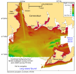
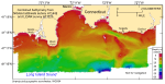
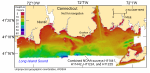
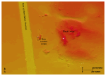
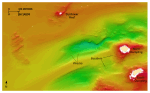
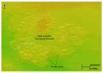
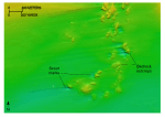
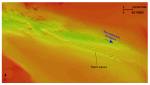
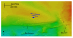
The combined multibeam-echosounder and LIDAR bathymetric data collected off New London and Niantic, Connecticut, can be displayed as grids and images that provide detailed topographic information with a continuous perspective and facilitate an improved understanding of the sea-floor geology and general benthic character (figs. 11, 12, 13). New London Data SetBedrock outcrops, which are visible in the bathymetry because they have a distinctive character and because they protrude above the surrounding sea floor, are common both along shorelines and offshore in the New London bathymetry dataset (fig. 11). Examples of nearshore exposures can be found off Goshen and Avery Points; offshore bedrock exposures include New London Ledge and Black Ledge (fig. 14). Elsewhere, rocky areas of the sea floor are composed primarily of bouldery lag deposits. These deposits were formed by strong tidal currents that winnowed finer grained sediments from the Orient Point-Fishers Island and Clumps moraines (Eldridge, 2009; Poppe and others, 1998b; Poppe and others, 2006b; Poppe and others, 2007a). Adjacent to the islands of North and South Dumpling, which are surface exposures of the largely submerged Clumps moraine, the strong tidal currents have also created two large, isolated scour depressions (fig. 15). In places, the bottom of the northern depression is more than 20 m deeper than the surrounding sea floor. Maximum water depths in the New London bathymetry dataset exceed 42 m and are found along the southwestern edge of the survey area. Anthropogenic features are also present in the New London bathymetry dataset. The most conspicuous of these features is the New London Harbor Channel, which extends south-southeast from the harbor and has thalweg depths of more than 13 m (fig. 14). Shipwrecks are also present and three of the wrecks lie in the scour depression adjacent to North Dumpling (fig. 15). The New London Dumping Ground lies 1.8 to 4.1 km south of the entrance to the harbor channel. The dredge spoils and sediments used to cap them, which can rise 5 to 6 m above the surrounding sea floor, are visible in the bathymetry (fig. 16). Other human artifacts in the dataset include mooring anchors, prop-scour depressions, buried cables, and bridge footings. Niantic Data SetMaximum water depths in the Niantic bathymetry dataset are approximately 65 m and occur along the southeastern edge of the survey area, where strong tidal currents flowing through the Race have eroded the sea floor (fig. 12; White and White, 2009). Erosion caused by these strong currents has also steepened bathymetric gradients, such as those south of Black Point, and formed isolated depressions, such as those in Twotree Island Channel. Elsewhere, especially at water depths shallower than 14 m, gradients are much gentler. Water depths shoal shoreward and around two major isolated bathymetric highs associated with the rising bedrock surface, Twotree Island and Bartlett Reef. Most of the other, smaller isolated bathymetric highs are also associated with bedrock outcrops, such as those south of Black Point, around Millstone Point, and south of Bartlett Reef. Where resolved in the bathymetric data, bedrock lineations parallel those present onshore and indicate that the effects of glaciation on the bedrock continue offshore under present-day Long Island Sound (Goldsmith, 1962; Poppe and others, 1998a; Poppe and others, 2006b). Depressions around many of the outcrops are further evidence of scour by the strong tidal currents, and scour-mark asymmetry indicates net sediment transport is predominantly westward at this location (fig. 17). The largest sand-wave fields in this study area are present at the eastern end of Twotree Island Channel (fig. 18) and off the southern tip of Bartlett Reef (fig. 19). Sand-wave asymmetry indicates net sediment transport is eastward out of Twotree Island Channel, but westward south of Bartlett Reef. Transverse sand waves dominate, but some barchanoid waves are present southeast of Bartlett Reef. |
Click on figures for larger images.
|

![]() U.S. Department of the Interior |
U.S. Geological Survey
U.S. Department of the Interior |
U.S. Geological Survey
URL: https://pubsdata.usgs.gov/pubs/of/2009/1231/html/bathy.html
Page Contact Information: Contact USGS
Page Last Modified: Wednesday, 07-Dec-2016 22:24:53 EST